Home
Weather London
WeatherRadar
RainfallRadar
TemperatureRadar
WindRadar
LightningRadar
Weather News
Editor's Pick
Discover the app
Weather widget
Contact us
Apps
Career
    Home /

    Sunny and dry days - Heatwave rolls on with cooler evenings

16:23
13 July 2026

Sunny and dry days
Heatwave rolls on with cooler evenings

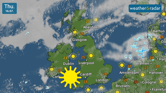
Satellite weather map of the UK and Ireland on Thursday 16.07 showing widespread sunshine across both countries, with temperatures ranging from 20°C in northeast Scotland to 28°C in southern England and 23 to 27°C across Ireland, alongside a large sunshine icon.
Mostly sunny days, after morning cloud cover eases each day.

Conditions through the week remain stable with high pressure maintaining a consistently warm and dry outlook for most.

Low cloud will take the edge off of the heat across central to eastern parts of England Tuesday morning, cooler still along the east coast thanks to an onshore breeze.

Daily highs are peaking in the low-30s in southern parts of England and Wales, while for Ireland the peak lays in the west, with around 28°C around Galway. Reaching only the upper-teens across Scotland as overnight temperatures fall to a more comfortable level.

The main chance of any rain arrives Wednesday. Small, brief showers are possible in Cornwall and Devon, pushing into southern and western Ireland too including a slight risk of isolated thunderstorms.

Otherwise, the outlook calls for generally dry, sunny days with heatwave thresholds continuing to be met, mostly in southern England and Wales.

Temperatures will cool slightly into the weekend but with no signs of a bigger change in the pattern of weather of the past weeks.

London

Mo
16
26
Tu
17
29
We
19
28
Th
18
28
Fr
17
28
Sa
16
25
Su
17
26
Mo
18
26
Tu
17
30
We
19
29
Th
18
29
Fr
19
28
Sa
18
28
Su
19
28
Max (°C)
Min (°C)
moreless

Manchester

Mo
14
26
Tu
14
26
We
15
27
Th
14
27
Fr
14
26
Sa
13
24
Su
15
24
Mo
14
24
Tu
16
27
We
16
24
Th
13
22
Fr
15
23
Sa
14
22
Su
14
22
Max (°C)
Min (°C)
moreless

Dublin

Mo
16
20
Tu
15
20
We
16
21
Th
14
23
Fr
15
24
Sa
13
21
Su
14
22
Mo
12
21
Tu
13
22
We
13
22
Th
11
20
Fr
13
21
Sa
12
20
Su
13
21
Max (°C)
Min (°C)
moreless

Edinburgh

Mo
11
18
Tu
12
17
We
12
18
Th
11
20
Fr
11
19
Sa
11
22
Su
12
20
Mo
13
21
Tu
13
21
We
13
21
Th
12
20
Fr
13
20
Sa
11
19
Su
12
20
Max (°C)
Min (°C)
moreless

Cardiff

Mo
15
26
Tu
16
29
We
18
30
Th
17
29
Fr
17
29
Sa
17
27
Su
16
25
Mo
17
26
Tu
17
26
We
17
25
Th
16
24
Fr
16
24
Sa
15
23
Su
16
23
Max (°C)
Min (°C)
moreless
Weather & Radar editorial team
More on the topic
Seeking the cooler scenes. Your weather - Your shots. . . Sunday, 12 July 2026
Split image showing a cat silhouetted on a fence at golden hour with the low sun behind it on the left, and a calm marina with boats, reflective water, and thin high clouds under bright sunshine on the right.
Sunday, 12 July 2026

Your weather - Your shots

Seeking the cooler scenes
Heat-health alerts ahead of heatwave. Across England. . . Tuesday, 7 July 2026
Temperature map of the UK and western Europe showing hot conditions across Britain, with temperatures reaching 33°C near London, 29°C around Cardiff, 24°C near Liverpool, and a large heat warning symbol highlighting elevated heat risk.
Tuesday, 7 July 2026

Across England

Heat-health alerts ahead of heatwave
Cooler nights and lower dew points. Less oppressive heatwave. . . Thursday, 9 July 2026
Split image showing the London skyline in hazy golden sunset light in the left and an overnight temperature map of the UK and Ireland on the right, with minimum temperatures ranging from 13°C in northeast Scotland to 18°C in southern England.
Thursday, 9 July 2026

Less oppressive heatwave

Cooler nights and lower dew points
All weather news
This might also interest you
Yet another typhoon in the Pacific. Gusts of over 185 mph. . . Friday, 3 July 2026
Wind forecast map of the western Pacific showing a powerful typhoon east of Guam with a well-defined eye, strong wind circulation, and a windsock warning icon.
Friday, 3 July 2026

Gusts of over 185 mph

Yet another typhoon in the Pacific
Increasingly gusty as low approaches. Overnight winds. . . Wednesday, 1 July 2026
Wind forecast map of the UK and northern Europe showing a low-pressure system centred near the Faroe Islands, with orange wind zones, airflow streamlines, and gusts reaching 45 mph in northeast Scotland and around 35 mph across Ireland and northern England.
Wednesday, 1 July 2026

Overnight winds

Increasingly gusty as low approaches
A sudden change in weather for Europe. Thunderstorms & tornadoes. . . Thursday, 2 July 2026
Split image showing a dramatic supercell thunderstorm with a lowering cloud base over farmland on the left, and a Europe lightning map on the right with dense lightning strikes and a thunderstorm warning symbol across central and southeastern Europe.
Thursday, 2 July 2026

Thunderstorms & tornadoes

A sudden change in weather for Europe
All articles
Weather & Radar

Weather & Radar is also available on

Google Play StoreApp Store

Company

Contact us Privacy Policy Legal info Accessibility statement

Services

Uploader

Socials

facebooktwittertikToklinkList