Home
Weather London
WeatherRadar
RainfallRadar
TemperatureRadar
WindRadar
LightningRadar
Weather News
Editor's Pick
Discover the app
Weather widget
Contact us
Apps
Career
    Home / Editor's Pick /

    Overnight winds - Increasingly gusty as low approaches

07:00
1 July 2026

Overnight winds
Increasingly gusty as low approaches

Growing stronger Wednesday evening.

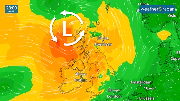
Conditions are taking a turn mid-week, with a low-pressure system passing north of Scotland delivering stronger gusts than we've seen in a while.

From Wednesday evening, gusting winds spread across Ireland into northern and western parts of the UK.

Overnight into Thursday, the low nears the Faroe Islands and by the morning Ireland sees the impact easing as gusts spread further south into eastern England.

It isn't just the gusts either, the wind is joined by rain in places, mostly on Wednesday with the heaviest rain spreading across Scotland towards the afternoon.

Keep an eye on both the WeatherRadar and WindRadar to track the conditions in the coming days.

Turbulent times in Europe as wellread more
Ryan Hathaway
More on the topic
Heatwave keeps a firm grip on Europe. Around 40°C in places. . . Monday, 13 July 2026
A collage featuring a temperature radar map of Europe and a fire-fighting aircraft in action over a forest fire. In the centre, a heat symbol warns of persistently high temperatures.
Monday, 13 July 2026

Around 40°C in places

Heatwave keeps a firm grip on Europe
Heat warnings cover much of Ireland. Until the weekend. . . Thursday, 16 July 2026
Temperature map of Ireland showing warm to hot conditions nationwide, with temperatures ranging from 27°C in Galway to 23°C in Dublin. A heat warning symbol to the west indicates elevated temperatures.
Thursday, 16 July 2026

Until the weekend

Heat warnings cover much of Ireland
Marine heatwave could affect our weather too. Wetter days to come?. . . Wednesday, 15 July 2026
Wednesday, 15 July 2026

Wetter days to come?

Marine heatwave could affect our weather too
All weather news
This might also interest you
Storm Chandra makes impact. Severe gales & heavy rain. . . Tuesday, 27 January 2026
Split image showing strong winds over the UK on a forecast map and widespread rain and snow on a weather radar map.
Tuesday, 27 January 2026

Severe gales & heavy rain

Storm Chandra makes impact
Turbulent weather in the Canary Islands. Storm and rain. . . Friday, 12 December 2025
Weather graphic showing rain and wind fields over the Canary Islands and a central warning symbol.
Friday, 12 December 2025

Storm and rain

Turbulent weather in the Canary Islands
Super Typhoon Bavi threatens Taiwan. Up to 1,000 mm of rain. . . Wednesday, 8 July 2026
The image shows an intense tropical cyclone over the western Pacific, east of Taiwan and the Philippines. The centre of the system is depicted as a light purple and white vortex with a clearly visible eye, surrounded by a ring of red and orange areas indicating the strongest wind speeds. A white arrow marks the typhoon’s predicted track towards the north-west, in the direction of Taiwan. To the west of the storm lie the Philippines, with the cities of Manila and Cebu; to the north of these lies Taiwan, with Taipei. Further west, the Chinese coast, including Hong Kong, and parts of Vietnam can be seen. The coloured wind map shows predominantly green areas outside the storm’s core, indicating significantly weaker winds. White streamlines illustrate the typhoon’s anti-clockwise circulation in the Northern Hemisphere. The highest wind speeds are concentrated around the eye of the cyclone.
Wednesday, 8 July 2026

Up to 1,000 mm of rain

Super Typhoon Bavi threatens Taiwan
All articles
Weather & Radar

Weather & Radar is also available on

Google Play StoreApp Store

Company

Contact us Privacy Policy Legal info Accessibility statement

Services

Uploader

Socials

facebooktwittertikToklinkList