Home
Weather London
WeatherRadar
RainfallRadar
TemperatureRadar
WindRadar
LightningRadar
Weather News
Editor's Pick
Discover the app
Weather widget
Contact us
Apps
Career
    Home / Editor's Pick /

    Meteor shower peaks with mixed visibility

18:00
11 November 2026

Better view Thursday
Meteor shower peaks with mixed visibility

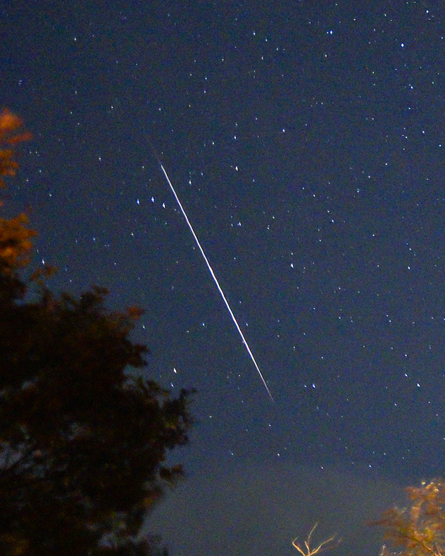
Long, bright white metoer streak cuts diagonally across a dark blue star-filled night sky, with silhouetted trees framing the lower left.
A shooting star from the Taurids snapped over Harzgerode, Germany in 2024. - © Torsten Brehme

The night sky will be shining with light this evening as November's first meteor shower reaches its peak.

Overnight, the Taurids will reach their peak. This is not a particularly active shower with only five shooting stars an hour on average but is know for producing slow moving meteors across the night sky, though still moving at a rate of 65,000 mph.

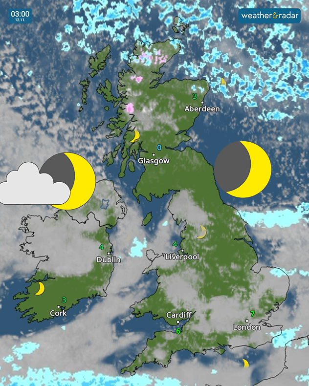
The moon will set relatively early, allowing plenty of time into the evening to spot the display. Visibility for the peak will be mixed, best across southern Ireland, Scotland, and pockets of England and Wales.

Weather map at 03:00 on 12.11 showing snow showers over northern Scotland, patchy cloud across Britain and Ireland, and temperatures of 0–7°C.
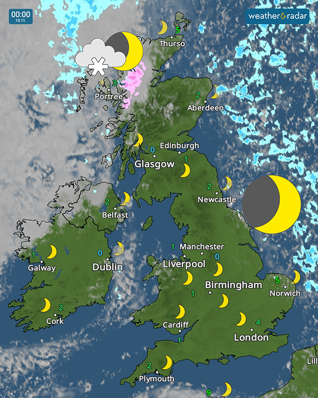
Weather map at 00:00 on 13.11 showing temperatures of 0-5°C across the UK and Ireland, clear skies with just pink snow showers in northwest Scotland.
1/2
Clearer skies open up in the early morning of Thursday.

Thursday evening brings almost perfect visibility, though it will get rather cold. Be sure to grab an extra layer or blanket if planning a night under the stars with temperatures falling below 0°C into Friday morning.

The Taurids will continue to be visible until November 20th.

Next week, the Leonids also reach their peak. A slightly more active shower with around 15 shooting stars an hour on display.

Ryan Hathaway

More on the topic

Further fog disruption expected. Growing dense overnight. . . Monday, 9 November 2026
Weather map showing widespread fog across the English Midlands, with a red fog warning symbol near Nottingham and temperatures of 4–6°C.
Monday, 9 November 2026

Growing dense overnight

Further fog disruption expected
Foggy mornings and crisp autumn days. Your weather - Your shots. . . Sunday, 8 November 2026
Sunday, 8 November 2026

Your weather - Your shots

Foggy mornings and crisp autumn days
Storm hits the Iberian Peninsula. Hurricane-force gusts. . . Wednesday, 11 November 2026
WindRadar showing a storm warning symbol and areas of strong winds over Portugal, southern Spain and Morocco.
Wednesday, 11 November 2026

Hurricane-force gusts

Storm hits the Iberian Peninsula
All weather news

This might also interest you

A stormy week in the skies above. Your weather - Your shots. . . Sunday, 30 August 2026
Split image showing lightning branching beneath dark storm clouds above rooftops on the left and an orange-pink sunset over a calm sea on the right.
Sunday, 30 August 2026

Your weather - Your shots

A stormy week in the skies above
A frozen start to the weekend. Icy conditions. . . Friday, 13 February 2026
UK temperature map dated 14.02 showing widespread subzero values in blue shading, with readings such as −4 in Glasgow, −3 in Dublin, and −2 in London, alongside a blue thermometer icon.
Friday, 13 February 2026

Icy conditions

A frozen start to the weekend
Seasonal warmth between spring thunder. Your weather - Your shots. . . Sunday, 19 April 2026
Split image showing coastal sunset with layered lenticular clouds over rooftops and palm trees on the left, and a green valley with river and hills under soft daylight on the right.
Sunday, 19 April 2026

Your weather - Your shots

Seasonal warmth between spring thunder
All articles
Weather & Radar

Weather & Radar is also available on

Google Play StoreApp Store

Company

Contact us Privacy Policy Legal info Accessibility statement

Services

Uploader

Socials

facebooktwittertikToklinkList