Home
Weather London
WeatherRadar
RainfallRadar
TemperatureRadar
WindRadar
LightningRadar
Weather News
Editor's Pick
Discover the app
Weather widget
Contact us
Apps
Career
    Home /

    Weekend outlook - Conditions remain unsettled for some

09:38
4 September 2026

Weekend outlook
Conditions remain unsettled for some

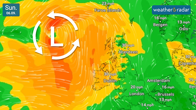
Wind forecast for Sunday 06.09 showing a deep Atlantic low west of Ireland, with winds around 30 mph across Ireland and Scotland and 20 mph near London.
An Atlantic low brings stronger winds on Sunday across western regions.

The weekend looks to remain rather unsettled as high pressure dominates southern Europe and low pressure hangs over the north-west, keeping the UK and Ireland in a changeable set-up.

Saturday begins rather unsettled thanks to a southerly to south-westerly airflow from the pressure situation. This brings rain and showers at times to parts of northern England and a generally dull day under cloud across much of Ireland.

Winds begin to pick up through Saturday, initially across Scotland, into northern England. This intensifies further on Sunday, particularly in coastal areas.

A passing low pressure system to the west of Scotland delivers those stronger gusts. Reaching up to 45 mph for Northern Ireland, and the north-western coast of Ireland. Similar gusts will also be felt across western Scotland, though remaining calmer for most of England.

Amid the gusty and showery conditions there will still be drier and sunnier spells at times, with temperatures at or around average in the north and east.

Further south, it may get rather warm and humid by Sunday with daily highs around the mid-20s.

London

Fr
20
20
Sa
13
23
Su
14
26
Mo
17
23
Tu
15
19
We
14
16
Th
12
19
Fr
13
20
Sa
13
21
Su
15
21
Mo
15
23
Tu
15
23
We
15
21
Th
15
23
Max (°C)
Min (°C)
moreless

Manchester

Fr
14
18
Sa
13
18
Su
13
22
Mo
15
17
Tu
14
15
We
11
16
Th
12
16
Fr
12
16
Sa
11
17
Su
13
18
Mo
12
18
Tu
13
19
We
12
16
Th
13
17
Max (°C)
Min (°C)
moreless

Dublin

Fr
14
19
Sa
12
18
Su
16
21
Mo
13
19
Tu
14
15
We
10
18
Th
11
19
Fr
10
17
Sa
11
19
Su
12
19
Mo
11
19
Tu
11
18
We
12
18
Th
13
19
Max (°C)
Min (°C)
moreless

Edinburgh

Fr
13
17
Sa
11
17
Su
13
18
Mo
13
17
Tu
11
16
We
10
18
Th
10
15
Fr
11
17
Sa
10
17
Su
12
19
Mo
11
17
Tu
12
18
We
11
17
Th
11
18
Max (°C)
Min (°C)
moreless

Cardiff

Fr
16
18
Sa
11
20
Su
13
24
Mo
16
19
Tu
15
20
We
12
17
Th
12
19
Fr
12
18
Sa
13
20
Su
14
20
Mo
14
20
Tu
14
19
We
15
20
Th
15
20
Max (°C)
Min (°C)
moreless
Weather & Radar editorial team
More on the topic
Summer of 2026: hottest on record. Breaking 2025 record. . . Tuesday, 1 September 2026
Aerial view of a large park with dry yellow-brown grass, intersecting footpaths, and a few people walking across the parched landscape beneath clear summer skies.
Tuesday, 1 September 2026

Breaking 2025 record

Summer of 2026: hottest on record
Hottest summer on record for Ireland. Beating 2025's record. . . Thursday, 3 September 2026
Temperature map of Ireland showing 29°C in Dublin, 26°C in Cork, 24°C in Belfast, and 23°C in Galway, with a red thermometer icon.
Thursday, 3 September 2026

Beating 2025's record

Hottest summer on record for Ireland
Slow moving rain brings flooding. More alerts live. . . Thursday, 27 August 2026
Weather radar at 11:00 on 27.08 showing widespread heavy rain from Liverpool through the Midlands to eastern England, with an arrow indicating rain moving north.
Thursday, 27 August 2026

More alerts live

Slow moving rain brings flooding
All weather news
This might also interest you
Damage in Germany after severe weather. Several tornadoes formed. . . Thursday, 20 August 2026
Split image: Weather map showing thunderstorms and a tornado symbol over western Germany. On the right, severe damage to buildings and rubble on a road can be seen.
Thursday, 20 August 2026

Several tornadoes formed

Damage in Germany after severe weather
Stormy weather in parts of Europe. Low-pressure system. . . Friday, 21 August 2026
Weather radar showing a low-pressure system over the Alps and its track towards the Baltic States. Next to it, a flooded road.
Friday, 21 August 2026

Low-pressure system

Stormy weather in parts of Europe
Severe weather damage in France. Tornado impacts. . . Tuesday, 25 August 2026
On the left, the weather radar shows numerous flashes of lightning over the south of France. On the right, severe tornado damage can be seen in Pomas, with damaged roofs, trees and vehicles.
Tuesday, 25 August 2026

Tornado impacts

Severe weather damage in France
All articles
Weather & Radar

Weather & Radar is also available on

Google Play StoreApp Store

Company

Contact us Privacy Policy Legal info Accessibility statement

Services

Uploader

Socials

facebooktwittertikToklinkList