Home
Weather London
WeatherRadar
RainfallRadar
TemperatureRadar
WindRadar
LightningRadar
Weather News
Editor's Pick
Discover the app
Weather widget
Contact us
Apps
Career
    Home / Editor's Pick /

    Breaking 2025 record - Summer of 2026: hottest on record

12:38
1 September 2026

Breaking 2025 record
Summer of 2026: hottest on record

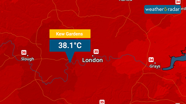
Temperature map of London showing 38.1°C at Kew Gardens, with surrounding readings of 35–36°C and deep red shading indicating extreme heat.
The hottest temperature of the year topped out at just over 38°C in August.

Data released by the Met Office has confirmed that this year's summer was provisionally the hottest on record after a spree of heatwaves.

Despite a cooler end to the season, a 40-day spell of temperatures above 30°C and five distinct heatwaves propelled this summer to the top, beating the summer of 2025.

With a high of 38.1°C marking the hottest day of the summer, and the fifth highest temperature ever, recorded at Kew Gardens on August 13th, the overall mean temperature across summer sat at 16.5°C.

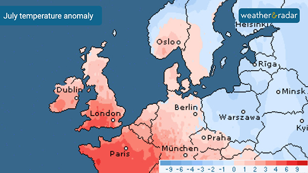
July temperature anomaly map of Europe showing warmer-than-average temperatures in red across the UK, Ireland, and western Europe, with cooler anomalies further east.
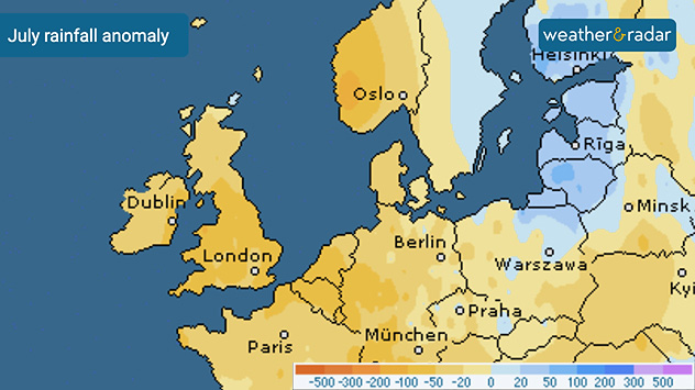
July rainfall anomaly map of Europe showing widespread rainfall deficits across the UK, Ireland, and western Europe, with wetter anomalies in parts of northeastern Europe.
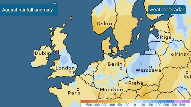
August rainfall anomaly map of Europe showing drier-than-average conditions in yellow and wetter areas in blue, including parts of the UK and central Europe.
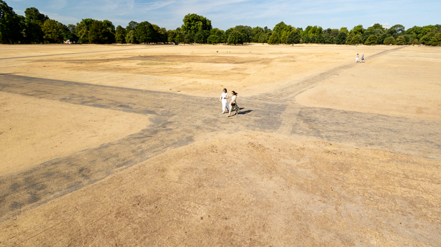
Aerial view of a large park with dry yellow-brown grass, intersecting footpaths, and a few people walking across the parched landscape beneath clear summer skies.
1/4
July's temperatures were widely above the norm.

Despite the fact that both June and July became the second-hottest of each month, and a cooler end to August, the overall consistency of hot weather has seen the seasonal record broken.

YearMean temperature
202616.5°C
202516.1°C
201815.7°C
200615.7°C
200315.7°C

It wasn't just the hottest, but the sunniest on record since reliable records have been kept from 1884, resulting in very little rainfall which led to drought declarations and widespread water use restrictions.

Despite the drought, late rain and thunderstorms in August prevented any national records from being broken. Though England did see the driest July on record, and third driest for the UK as a whole.

As 2026 enters the history books, the infamous heatwave of 1976 falls lower in the list of hottest summers, now seventh overall.

Ryan Hathaway
More on the topic
Severe weather brings disruption. Gales and rain. . . Wednesday, 14 October 2026
Split weather graphic showing winds up to 45 mph near Aberdeen and red, orange and yellow wind warning zones across Scotland and Ireland.
Wednesday, 14 October 2026

Gales and rain

Severe weather brings disruption
Warnings for a windswept Wednesday. Coastal gales. . . Tuesday, 13 October 2026
Wind map showing 45 mph near Aberdeen, 40 mph near Glasgow and Cork, and red strong wind warning symbols across western Scotland and Ireland.
Tuesday, 13 October 2026

Coastal gales

Warnings for a windswept Wednesday
Former hurricane to record storm. Isaias affecting Europe. . . Wednesday, 14 October 2026
WindRadar shows a powerful storm system south-west of Iceland. Red and purple colours indicate extreme wind speeds. Arrows show the direction of rotation, whilst a windsock symbol warns of a storm.
Wednesday, 14 October 2026

Isaias affecting Europe

Former hurricane to record storm
All weather news
This might also interest you
Long-term trends need a pinch of salt. 40 °C in July?. . . Tuesday, 30 June 2026
Temperature radar of 2022 heatwave where the all-time temperature record in the UK was set. Warning symbol overlain.
Tuesday, 30 June 2026

40 °C in July?

Long-term trends need a pinch of salt
Super Typhoon Bavi threatens Taiwan. Up to 1,000 mm of rain. . . Wednesday, 8 July 2026
The image shows an intense tropical cyclone over the western Pacific, east of Taiwan and the Philippines. The centre of the system is depicted as a light purple and white vortex with a clearly visible eye, surrounded by a ring of red and orange areas indicating the strongest wind speeds. A white arrow marks the typhoon’s predicted track towards the north-west, in the direction of Taiwan. To the west of the storm lie the Philippines, with the cities of Manila and Cebu; to the north of these lies Taiwan, with Taipei. Further west, the Chinese coast, including Hong Kong, and parts of Vietnam can be seen. The coloured wind map shows predominantly green areas outside the storm’s core, indicating significantly weaker winds. White streamlines illustrate the typhoon’s anti-clockwise circulation in the Northern Hemisphere. The highest wind speeds are concentrated around the eye of the cyclone.
Wednesday, 8 July 2026

Up to 1,000 mm of rain

Super Typhoon Bavi threatens Taiwan
A stormy week in the skies above. Your weather - Your shots. . . Sunday, 30 August 2026
Split image showing lightning branching beneath dark storm clouds above rooftops on the left and an orange-pink sunset over a calm sea on the right.
Sunday, 30 August 2026

Your weather - Your shots

A stormy week in the skies above
All articles
Weather & Radar

Weather & Radar is also available on

Google Play StoreApp Store

Company

Contact us Privacy Policy Legal info Accessibility statement

Services

Uploader

Socials

facebooktwittertikToklinkList