Home
Weather London
WeatherRadar
RainfallRadar
TemperatureRadar
WindRadar
LightningRadar
Weather News
Editor's Pick
Discover the app
Weather widget
Contact us
Apps
Career
    Home / Editor's Pick /

    Coastal gales - Warnings for a windswept Wednesday

11:00
13 October 2026

Coastal gales
Warnings for a windswept Wednesday

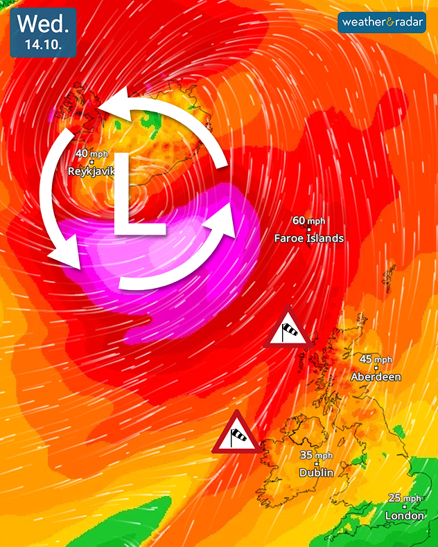
Wind map for Wednesday 14.10 showing deep low pressure near Iceland, 60 mph winds at the Faroe Islands and 45 mph near Aberdeen, with wind warnings.
Ex-Hurricane Isaias influences our weather on Wednesday prompting warnings.

Weather warnings have been issued for Ireland and the UK ahead of strong winds sweeping through the countries on Wednesday.

The remnants of Hurricane Isaias will pass between Iceland and Scotland during the day, still a very deep low-pressure system this beings strong winds, with gales along western coasts.

Wind warnings have been issued across western Ireland, from Co. Donegal down to Co. Galway, while in the UK a yellow wind warning covers parts of the Western Highlands & Islands of Scotland.

The strongest gusts are likely to be felt later in the day. Before the system arrives, Tuesday is already seeing another bout of unsettled conditions.

These are not as strong as Wednesday, where peak gusts of up to 65 mph are expected in western Scotland, and even higher in exposed western coasts, potentially up to 70 mph.

Though peak gusts are still likely to be around 40 mph including for Glasgow, Galway, and Belfast.

Track the system as it moves byWindRadar
Ryan Hathaway
More on the topic
Thundery showers move through today. N. Ireland to Scotland. . . Tuesday, 13 October 2026
Weather radar showing blue rain bands and lightning across western and central Scotland, with storms near Glasgow and northeast of Edinburgh.
Tuesday, 13 October 2026

N. Ireland to Scotland

Thundery showers move through today
Windswept Friday as gusts spread wide. Across the UK and Ireland. . . Thursday, 8 October 2026
Wind map showing gusts of 40 mph near Dublin, Liverpool and Cardiff, 35 mph near Glasgow and London, and a strong wind warning symbol.
Thursday, 8 October 2026

Across the UK and Ireland

Windswept Friday as gusts spread wide
Hurricane threatens the US coast. First storm of the season. . . Thursday, 8 October 2026
The WindRadar shows a powerful hurricane off the US Gulf Coast. Wind speeds of 75 miles per hour are being recorded around the centre of the storm.
Thursday, 8 October 2026

First storm of the season

Hurricane threatens the US coast
All weather news
This might also interest you
Seasonal warmth between spring thunder. Your weather - Your shots. . . Sunday, 19 April 2026
Split image showing coastal sunset with layered lenticular clouds over rooftops and palm trees on the left, and a green valley with river and hills under soft daylight on the right.
Sunday, 19 April 2026

Your weather - Your shots

Seasonal warmth between spring thunder
New records for England and Wales. Broken again tomorrow?. . . Thursday, 25 June 2026
Temperature map of southwest Britain on 25.06 showing extreme heat across southern Wales and southwest England, with Bute Park in Cardiff highlighted at 34.2°C and Yeovilton at 36.4°C amid widespread deep red heat zones.
Thursday, 25 June 2026

Broken again tomorrow?

New records for England and Wales
Bright and warm conditions take hold. Spring-like outlook. . . Thursday, 23 April 2026
Split UK map showing warm temperatures up to 21 degrees in orange on the left and clear sunny conditions with temperatures from 12 to 18 degrees on the right, with sun icons across the country.
Thursday, 23 April 2026

Spring-like outlook

Bright and warm conditions take hold
All articles
Weather & Radar

Weather & Radar is also available on

Google Play StoreApp Store

Company

Contact us Privacy Policy Legal info Accessibility statement

Services

Uploader

Socials

facebooktwittertikToklinkList