Home
Weather London
WeatherRadar
RainfallRadar
TemperatureRadar
WindRadar
LightningRadar
Weather News
Editor's Pick
Discover the app
Weather widget
Contact us
Apps
Career
    Home / Editor's Pick /

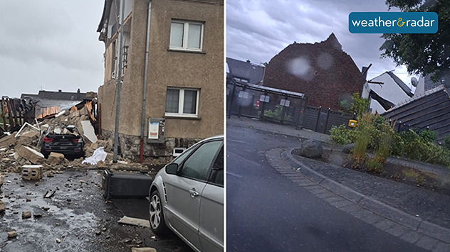
    Damage in Germany after severe weather: Several tornadoes suspected in Germany

13:41
20 August 2026

Several tornadoes formed
Damage in Germany after severe weather

Several tornadoes and severe thunderstorms left a trail of destruction across central Germany on Wednesday evening.

In the Westerwald, between Cologne and Frankfurt, roofs were torn off, walls were ripped from houses, and entire sections of woodland were destroyed.

According to local residents, the storm swept through the German town of Höhr-Grenzhausen around 07:20 pm.

The storms also left their mark in the federal states of Hesse, Thuringia and Brandenburg where trees were uprooted and basements were flooded.

In Fürstenwalde, south-east of Berlin, a tornado also caused severe damage, leaving three people injured. Several blocks of flats and a nursery were damaged, and some flats are uninhabitable for the time being.

Weather & Radar editorial team
More on the topic
Switch from drought to waterlogged. Ireland's new challenge. . . Thursday, 1 October 2026
Split image showing widespread heavy rain across Ireland besid aerial farmland covered by extensive standing floodwater.
Thursday, 1 October 2026

Ireland's new challenge

Switch from drought to waterlogged
Turbulence in the eastern Mediterranean. Floods and landslides. . . Friday, 2 October 2026
Weather Radar showing a low-pressure system over the eastern Mediterranean
Friday, 2 October 2026

Floods and landslides

Turbulence in the eastern Mediterranean
Hurricane Polo is heading for Mexico. Severe weather risk. . . Monday, 28 September 2026
Wind map showing an intense tropical cyclone southwest of Baja California, with an arrow toward the peninsula and flood and strong wind warning symbols.
Monday, 28 September 2026

Severe weather risk

Hurricane Polo is heading for Mexico
All weather news
This might also interest you
Bright and warm conditions take hold. Spring-like outlook. . . Thursday, 23 April 2026
Split UK map showing warm temperatures up to 21 degrees in orange on the left and clear sunny conditions with temperatures from 12 to 18 degrees on the right, with sun icons across the country.
Thursday, 23 April 2026

Spring-like outlook

Bright and warm conditions take hold
Long-term trends need a pinch of salt. 40 °C in July?. . . Tuesday, 30 June 2026
Temperature radar of 2022 heatwave where the all-time temperature record in the UK was set. Warning symbol overlain.
Tuesday, 30 June 2026

40 °C in July?

Long-term trends need a pinch of salt
Super Typhoon Bavi threatens Taiwan. Up to 1,000 mm of rain. . . Wednesday, 8 July 2026
The image shows an intense tropical cyclone over the western Pacific, east of Taiwan and the Philippines. The centre of the system is depicted as a light purple and white vortex with a clearly visible eye, surrounded by a ring of red and orange areas indicating the strongest wind speeds. A white arrow marks the typhoon’s predicted track towards the north-west, in the direction of Taiwan. To the west of the storm lie the Philippines, with the cities of Manila and Cebu; to the north of these lies Taiwan, with Taipei. Further west, the Chinese coast, including Hong Kong, and parts of Vietnam can be seen. The coloured wind map shows predominantly green areas outside the storm’s core, indicating significantly weaker winds. White streamlines illustrate the typhoon’s anti-clockwise circulation in the Northern Hemisphere. The highest wind speeds are concentrated around the eye of the cyclone.
Wednesday, 8 July 2026

Up to 1,000 mm of rain

Super Typhoon Bavi threatens Taiwan
All articles
Weather & Radar

Weather & Radar is also available on

Google Play StoreApp Store

Company

Contact us Privacy Policy Legal info Accessibility statement

Services

Uploader

Socials

facebooktwittertikToklinkList