Home
Weather London
WeatherRadar
RainfallRadar
TemperatureRadar
WindRadar
LightningRadar
Weather News
Editor's Pick
Discover the app
Weather widget
Contact us
Apps
Career
    Home /

    Remaining changeable - fronts continue to influence the week

11:14
14 September 2026

Remaining changeable
Fronts continue to influence the week

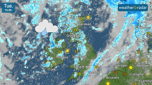
Weather map for Tuesday 15.09 showing scattered showers across the UK and Ireland, with temperatures from 15°C in Glasgow to 20°C near London.
A common sight on the WeatherRadar this week with many showers across the UK and Ireland.

The coming week will remain changeable with more weather fronts continuing to pass through the UK and Ireland.

Heavy rain will first push through from Monday afternoon, into the evening. By Tuesday outbreaks of showers persist as the front moves through England and Wales, though with some sunny spells in the north. Temperatures remain mild with southern England also feeling humid.

It's a similar pattern for Wednesday, a mix of showers and sunny spells through the day, a clearer afternoon, and a fresh front arriving overnight into Thursday.

By Thursday, rainfall accumulation may reach 30-50 mm in places, notably in the Scottish Highlands after the frontal rain. Coastal areas of Ireland and Scotland see lower totals around 15-30 mm while it generally remains drier in the south of the UK.

On Thursday itself, a low pressure system passing to the north brings stronger winds for most. Gusts of up to 35 mph are widely expected, stronger for those towards the north-west and in exposed locations.

No change by Friday into the weekend as the fronts continue. A better chance of more settled conditions again in the south. Keep an eye on the WeatherRadar throughout for the latest.

London

Mo
18
23
Tu
18
21
We
12
19
Th
13
19
Fr
12
19
Sa
16
23
Su
17
22
Mo
14
22
Tu
15
23
We
15
23
Th
14
22
Fr
15
23
Sa
16
23
Su
13
21
Max (°C)
Min (°C)
moreless

Manchester

Mo
17
23
Tu
15
17
We
12
16
Th
12
16
Fr
12
16
Sa
14
19
Su
11
17
Mo
12
19
Tu
14
18
We
12
18
Th
12
18
Fr
12
18
Sa
13
18
Su
10
17
Max (°C)
Min (°C)
moreless

Dublin

Mo
16
23
Tu
13
18
We
11
17
Th
12
17
Fr
11
16
Sa
14
18
Su
10
17
Mo
14
21
Tu
12
18
We
11
18
Th
10
19
Fr
9
17
Sa
10
17
Su
8
16
Max (°C)
Min (°C)
moreless

Edinburgh

Mo
13
20
Tu
13
18
We
11
16
Th
12
15
Fr
11
16
Sa
12
16
Su
11
17
Mo
12
18
Tu
11
16
We
9
16
Th
12
18
Fr
11
17
Sa
12
18
Su
10
16
Max (°C)
Min (°C)
moreless

Cardiff

Mo
18
21
Tu
16
19
We
12
18
Th
12
18
Fr
12
17
Sa
16
21
Su
14
18
Mo
15
20
Tu
15
20
We
15
20
Th
14
19
Fr
13
20
Sa
14
19
Su
12
17
Max (°C)
Min (°C)
moreless
Weather & Radar editorial team
More on the topic
Severe weather hits Mallorca and Italy. Severe thunderstorms. . . Thursday, 10 September 2026
Numerous thunderstorms are sweeping across La Palma. The many lightning symbols on the radar and lightning map show that there is heavy lightning activity across large parts of the island. The thunderstorms are striking particularly in the island’s interior and in the south. On the right, you can see the aftermath: a large fallen tree has buried a car beneath it. Emergency services are clearing up the damage. So, along with the thunderstorms, not only heavy rain but also gusts of wind can become a problem.
Thursday, 10 September 2026

Severe thunderstorms

Severe weather hits Mallorca and Italy
A marked change in the weather. Cold front heading south. . . Monday, 7 September 2026
Map of Europe showing a cold front stretching from Scandinavia to Spain. Thunderstorms are shown in southern and central Europe.
Monday, 7 September 2026

Cold front heading south

A marked change in the weather
Warm waters raise severe weather risk. Mediterranean bathtub. . . Friday, 4 September 2026
Left: Map showing water temperatures in the Mediterranean; Right: Dark clouds over a stretch of Mediterranean coastline. A bolt of lightning strikes and a curtain of rain can be seen.
Friday, 4 September 2026

Mediterranean bathtub

Warm waters raise severe weather risk
All weather news
This might also interest you
Extreme weather contrasts in Europe. Heat versus constant rain. . . Thursday, 3 September 2026
On the left, the Temperature Radar shows high temperatures in Spain; on the right, the Weather Radar shows rain in Central Europe
Thursday, 3 September 2026

Heat versus constant rain

Extreme weather contrasts in Europe
Europe's storm situation still volatile. Supercell danger. . . Friday, 28 August 2026
Split screen. On the left, a weather map of Europe showing thunderstorms, lightning and a warning symbol. On the right, a photograph of a severe thunderstorm
Friday, 28 August 2026

Supercell danger

Europe's storm situation still volatile
Hottest summer on record for Ireland. Beating 2025's record. . . Thursday, 3 September 2026
Temperature map of Ireland showing 29°C in Dublin, 26°C in Cork, 24°C in Belfast, and 23°C in Galway, with a red thermometer icon.
Thursday, 3 September 2026

Beating 2025's record

Hottest summer on record for Ireland
All articles
Weather & Radar

Weather & Radar is also available on

Google Play StoreApp Store

Company

Contact us Privacy Policy Legal info Accessibility statement

Services

Uploader

Socials

facebooktwittertikToklinkList