Home
Weather London
WeatherRadar
RainfallRadar
TemperatureRadar
WindRadar
LightningRadar
Weather News
Editor's Pick
Discover the app
Weather widget
Contact us
Apps
Career
    Home / Editor's Pick /

    A marked change in the weather – a cold front moving in from the south-east

10:00
7 September 2026

Cold front heading south
A marked change in the weather

The week is set to start off hot once again in many parts of Europe. However, a cold front is slowly working its way south-eastwards from the eastern Atlantic and the North Sea.

In its wake, temperatures in many places will plummet by more than 10 degrees.

The change also brings strong gustsWindRadar Europe

The change in the weather is set to be quite dramatic: from the Balearic Islands across the Alps to northern Italy, heavy showers and thunderstorms – some of them severe – will sweep through until the middle of the week.

In addition, prolonged heavy rain with significant rainfall is forecast for the foothills of the Alps.

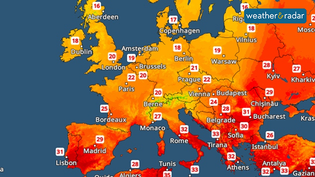
Temperature map of Europe showing 31°C in Lisbon, 29°C in Madrid, 32°C in Rome and Athens, and cooler readings of 16–20°C across the UK and northern Europe.
TemperatureRadar: The heatwave will be retreating towards the southern Mediterranean by Thursday.

In the second half of the week, the focus will shift towards the Adriatic region and the Balkans. There, with the air feeling muggy, things could get quite stormy with heavy rain, hail and gusts of wind posing a local risk of severe weather.

Weather & Radar editorial team
More on the topic
Summer of 2026: hottest on record. Breaking 2025 record. . . Tuesday, 1 September 2026
Aerial view of a large park with dry yellow-brown grass, intersecting footpaths, and a few people walking across the parched landscape beneath clear summer skies.
Tuesday, 1 September 2026

Breaking 2025 record

Summer of 2026: hottest on record
Warm waters raise severe weather risk. Mediterranean bathtub. . . Friday, 4 September 2026
Left: Map showing water temperatures in the Mediterranean; Right: Dark clouds over a stretch of Mediterranean coastline. A bolt of lightning strikes and a curtain of rain can be seen.
Friday, 4 September 2026

Mediterranean bathtub

Warm waters raise severe weather risk
Rain and blustery winds spread. Frontal influence. . . Wednesday, 2 September 2026
Split weather graphic showing widespread rain across the UK and Ireland alongside winds of 25-35 mph, strongest around Cardiff and the south of the UK.
Wednesday, 2 September 2026

Frontal influence

Rain and blustery winds spread
All weather news
This might also interest you
Seasonal warmth between spring thunder. Your weather - Your shots. . . Sunday, 19 April 2026
Split image showing coastal sunset with layered lenticular clouds over rooftops and palm trees on the left, and a green valley with river and hills under soft daylight on the right.
Sunday, 19 April 2026

Your weather - Your shots

Seasonal warmth between spring thunder
Storm Chandra makes impact. Severe gales & heavy rain. . . Tuesday, 27 January 2026
Split image showing strong winds over the UK on a forecast map and widespread rain and snow on a weather radar map.
Tuesday, 27 January 2026

Severe gales & heavy rain

Storm Chandra makes impact
Historic Storm Éowyn arrives. On this day.... . . Saturday, 24 January 2026
Split image showing a person in a yellow jacket struggling against strong winds and heavy rain on a street at night on the left, and an Irish wind forecast map on the right with red and purple shading, gusts up to 75 mph, and a wind warning icon, divided by a curved white line.
Saturday, 24 January 2026

On this day...

Historic Storm Éowyn arrives
All articles
Weather & Radar

Weather & Radar is also available on

Google Play StoreApp Store

Company

Contact us Privacy Policy Legal info Accessibility statement

Services

Uploader

Socials

facebooktwittertikToklinkList