Home
Weather London
WeatherRadar
RainfallRadar
TemperatureRadar
WindRadar
LightningRadar
Weather News
Editor's Pick
Discover the app
Weather widget
Contact us
Apps
Career
    Home / Editor's Pick /

    Prelude to Austen as winds grow and rain spreads Wednesday

08:59
21 October 2026

Prelude to Austen
Winds grow and rain spreads Wednesday

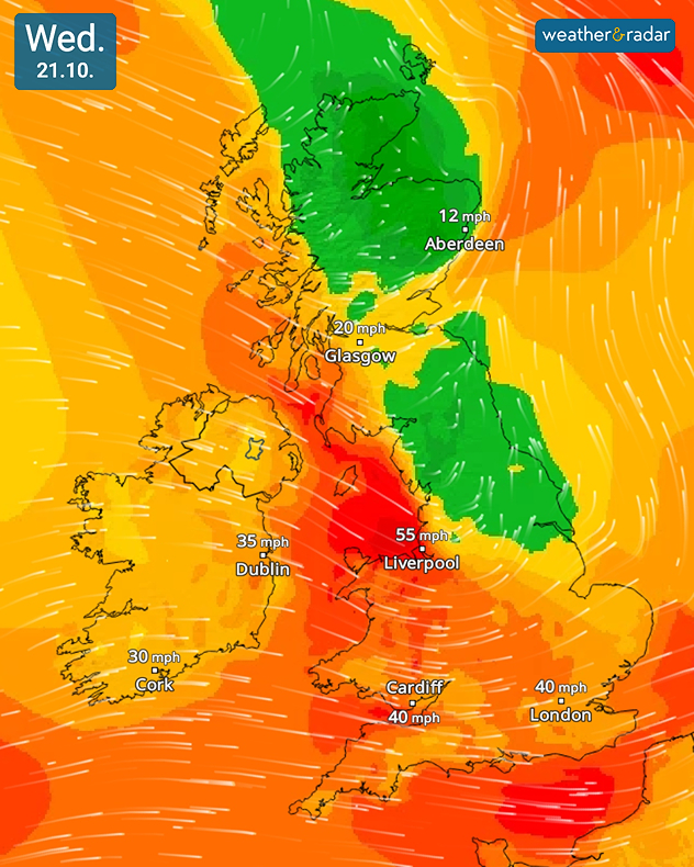
Wind forecast for Wednesday 21.10 showing 55 mph near Liverpool, 40 mph near Cardiff and London, and lighter 12 to 20 mph winds across Scotland.
Winds pack a punch through Wednesday.

While all eyes are on Friday and Storm Austen, Wednesday brings an early taste of the storm with strong gusting winds and spreading rain.

The strongest gusts will be felt in north-west Wales and England, reaching around 60 mph in Holyhead and 55 mph in Liverpool, slightly lower gusts of 40 to 50 mph spread across Wales and the south-west at times in the early afternoon.

Rain grows heavier at times too. With accumulations of up to 30 mm expected by the end of the day along the southern coasts of Hampshire and Dorset, and around the Elan Valley in Waves. Some surface flooding could be seen.

Before reaching the UK with full force, eastern Ireland first feels the impact of the wind, gusts of up to 45 mph (70 km/h) are expected in Dublin. Scotland is spared from the gusting winds until the late afternoon, into the evening.

Rain and winds from Austen at the end of the week will be more severe than what we see Wednesday. Gales could reach speeds of 70 mph in exposed south-western regions of England.

Some uncertainty still remains on the exact path of Austen, impacts could be greater or lesser than predicted until this become clear.

Ryan Hathaway

More on the topic

Severe weather hits Turkey and Greece. Torrential rain and storms. . . Thursday, 15 October 2026
On the left, a yellow bus is submerged in deep floodwater. On the right, the weather radar shows numerous thunderstorms over Greece and Turkey. Warning symbols indicate flooding and thunderstorms.
Thursday, 15 October 2026

Torrential rain and storms

Severe weather hits Turkey and Greece
First major storm of the season. Storm Austen named. . . Tuesday, 20 October 2026
On the left, WindRadar shows a storm system over the UK with strong winds. On the right, high waves are crashing against a sea wall. A warning symbol indicates a storm.
Tuesday, 20 October 2026

Storm Austen named

First major storm of the season
High-pressure shifts the weather pattern. Change in Europe. . . Friday, 16 October 2026
Split European weather maps showing low pressure near Norway shifting to high pressure over Scandinavia, with arrows indicating changing airflow patterns.
Friday, 16 October 2026

Change in Europe

High-pressure shifts the weather pattern
All weather news

This might also interest you

A stormy week in the skies above. Your weather - Your shots. . . Sunday, 30 August 2026
Split image showing lightning branching beneath dark storm clouds above rooftops on the left and an orange-pink sunset over a calm sea on the right.
Sunday, 30 August 2026

Your weather - Your shots

A stormy week in the skies above
Historic Storm Éowyn arrives. On this day.... . . Saturday, 24 January 2026
Split image showing a person in a yellow jacket struggling against strong winds and heavy rain on a street at night on the left, and an Irish wind forecast map on the right with red and purple shading, gusts up to 75 mph, and a wind warning icon, divided by a curved white line.
Saturday, 24 January 2026

On this day...

Historic Storm Éowyn arrives
Super Typhoon Bavi threatens Taiwan. Up to 1,000 mm of rain. . . Wednesday, 8 July 2026
The image shows an intense tropical cyclone over the western Pacific, east of Taiwan and the Philippines. The centre of the system is depicted as a light purple and white vortex with a clearly visible eye, surrounded by a ring of red and orange areas indicating the strongest wind speeds. A white arrow marks the typhoon’s predicted track towards the north-west, in the direction of Taiwan. To the west of the storm lie the Philippines, with the cities of Manila and Cebu; to the north of these lies Taiwan, with Taipei. Further west, the Chinese coast, including Hong Kong, and parts of Vietnam can be seen. The coloured wind map shows predominantly green areas outside the storm’s core, indicating significantly weaker winds. White streamlines illustrate the typhoon’s anti-clockwise circulation in the Northern Hemisphere. The highest wind speeds are concentrated around the eye of the cyclone.
Wednesday, 8 July 2026

Up to 1,000 mm of rain

Super Typhoon Bavi threatens Taiwan
All articles
Weather & Radar

Weather & Radar is also available on

Google Play StoreApp Store

Company

Contact us Privacy Policy Legal info Accessibility statement

Services

Uploader

Socials

facebooktwittertikToklinkList