Home
Weather London
WeatherRadar
RainfallRadar
TemperatureRadar
WindRadar
LightningRadar
Weather News
Editor's Pick
Discover the app
Weather widget
Contact us
Apps
Career
    Home / Editor's Pick /

    Winter takes a break – weather conditions undergo fundamental change

10:25
24 November 2025

Winter takes a break
Weather conditions change dramatically

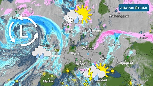
Thursday's WeatherRadar clearly shows the Atlantic low pressure system bringing major weather changes to Europe.

After the brief winter interlude, signs now point to mild weather. The general weather situation is changing and putting winter on hold for the time being.

From the second half of the week onwards, low-pressure systems from the Atlantic will increasingly prevail. Not only will they bring changeable weather, but they will also draw warm air from North Africa. This means that a significant rise in temperature is on the way.

Snow fans now need a lot of patience

Maximum temperatures in Western Europe will rise to 10 to 15 degrees, and even higher in the warmest regions of Spain and Portugal. But it will also become milder in Scandinavia: instead of persistent frost, temperatures above zero will be common, with only the far north experiencing light frost.

Once established, these weather conditions are likely to persist. Atlantic lows will remain active, with highs from the east having little chance of developing.

For snow fans, this means patience is required – conditions are likely to remain mild and often wet well into December.

London

Fr
18
28
Sa
17
29
Su
18
25
Mo
17
26
Tu
18
29
We
20
31
Th
19
29
Fr
19
29
Sa
18
27
Su
19
27
Mo
18
29
Tu
18
30
We
20
31
Th
21
33
Max (°C)
Min (°C)
moreless

Birmingham

Fr
14
26
Sa
14
25
Su
15
21
Mo
15
25
Tu
15
27
We
16
27
Th
15
26
Fr
16
26
Sa
16
25
Su
15
24
Mo
14
26
Tu
14
27
We
17
27
Th
17
29
Max (°C)
Min (°C)
moreless

Dublin

Fr
12
23
Sa
15
20
Su
15
20
Mo
13
23
Tu
19
23
We
15
22
Th
11
20
Fr
13
20
Sa
14
20
Su
14
21
Mo
11
19
Tu
13
21
We
13
22
Th
13
22
Max (°C)
Min (°C)
moreless

Edinburgh

Fr
13
19
Sa
15
20
Su
13
19
Mo
12
18
Tu
17
21
We
14
22
Th
11
19
Fr
13
19
Sa
13
19
Su
13
20
Mo
13
21
Tu
12
20
We
14
22
Th
14
22
Max (°C)
Min (°C)
moreless

Cardiff

Fr
14
26
Sa
13
23
Su
17
22
Mo
15
23
Tu
14
25
We
17
25
Th
15
23
Fr
16
24
Sa
16
24
Su
16
23
Mo
15
23
Tu
15
23
We
17
25
Th
17
25
Max (°C)
Min (°C)
moreless

Belfast

Fr
14
22
Sa
16
19
Su
15
18
Mo
14
20
Tu
18
21
We
13
21
Th
10
18
Fr
13
19
Sa
14
19
Su
14
19
Mo
12
20
Tu
13
21
We
14
22
Th
14
22
Max (°C)
Min (°C)
moreless
Jürgen Vollmer
Ryan Hathaway
More on the topic
Long-term trends need a pinch of salt. Heading over 40°C?. . . Tuesday, 21 July 2026
Temperature radar of 2022 heatwave where the all-time temperature record in the UK was set. Warning symbol overlain.
Tuesday, 21 July 2026

Heading over 40°C?

Long-term trends need a pinch of salt
Severe damage along the Adriatic coast. Huge hail and storms. . . Wednesday, 22 July 2026
Two hands are holding huge hailstones; next to them is a weather map showing thunderstorms and frequent lightning over the Adriatic coast and the western Balkans.
Wednesday, 22 July 2026

Huge hail and storms

Severe damage along the Adriatic coast
Drought for North Wales and Upper Severn. 2% of average rainfall. . . Thursday, 23 July 2026
Split image showing a July rainfall anomaly map of Europe on the left with below-average rainfall across the UK, Ireland, and much of western and central Europe, and an active moorland wildfire on the right producing flames and thick smoke near homes.
Thursday, 23 July 2026

2% of average rainfall

Drought for North Wales and Upper Severn
All weather news
This might also interest you
Turbulent weather in the Canary Islands. Storm and rain. . . Friday, 12 December 2025
Weather graphic showing rain and wind fields over the Canary Islands and a central warning symbol.
Friday, 12 December 2025

Storm and rain

Turbulent weather in the Canary Islands
Flooding, gales, and heavy snow. Storm Chandra. . . Tuesday, 27 January 2026
Split image showing aerial flooding in a town with muddy water covering roads on the left, and a rural road on the right blocked by heavy snowfall with vans stopped and a person walking in snow.
Tuesday, 27 January 2026

Storm Chandra

Flooding, gales, and heavy snow
Super Typhoon Bavi threatens Taiwan. Up to 1,000 mm of rain. . . Wednesday, 8 July 2026
The image shows an intense tropical cyclone over the western Pacific, east of Taiwan and the Philippines. The centre of the system is depicted as a light purple and white vortex with a clearly visible eye, surrounded by a ring of red and orange areas indicating the strongest wind speeds. A white arrow marks the typhoon’s predicted track towards the north-west, in the direction of Taiwan. To the west of the storm lie the Philippines, with the cities of Manila and Cebu; to the north of these lies Taiwan, with Taipei. Further west, the Chinese coast, including Hong Kong, and parts of Vietnam can be seen. The coloured wind map shows predominantly green areas outside the storm’s core, indicating significantly weaker winds. White streamlines illustrate the typhoon’s anti-clockwise circulation in the Northern Hemisphere. The highest wind speeds are concentrated around the eye of the cyclone.
Wednesday, 8 July 2026

Up to 1,000 mm of rain

Super Typhoon Bavi threatens Taiwan
All articles
Weather & Radar

Weather & Radar is also available on

Google Play StoreApp Store

Company

Contact us Privacy Policy Legal info Accessibility statement

Services

Uploader

Socials

facebooktwittertikToklinkList