Home
Weather London
WeatherRadar
RainfallRadar
TemperatureRadar
WindRadar
LightningRadar
Weather News
Editor's Pick
Discover the app
Weather widget
Contact us
Apps
Career
    Home / Weather News /

    Severe gales & heavy rain: Storm Chandra arrives Tuesday

11:04
27 January 2026

Severe gales & heavy rain
Storm Chandra makes impact

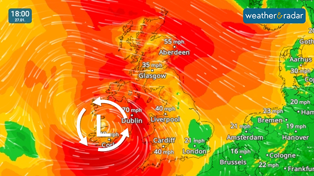
Severe gales and widespread strong winds for Tuesday.

Storm Chandra, the third named storm of the current season, has been named for impact on Tuesday.

The system will bring severe gales with gusts of up to 75 mph in coastal areas of Ireland and Northern Ireland. Strong, blustery conditions also spread more widely.

Rainfall accumulation levels reached 100 mm at White Barrow, South Dartmoor overnight while widespread flood warnings have been issued.

In Ottery Saint Mary, Devon, the River Otter reached a record high as rain fell in the night, but is now dropping.

Third named storm

Chandra follows storms Amy and Bram in October and December respectively. Despite this, the UK and Ireland have also felt the impacts from Benjamin, Claudia, and Goretti in recent months, all named by European meteorological agencies.

Flights and ferries were also cancelled across the UK due to the gales.

The stormy conditions will be relatively short-lived, with conditions mostly calming again by Wednesday.

Follow Chandra's progressWindRadar
Ryan Hathaway
More on the topic
Severe weather hits Mallorca and Italy. Severe thunderstorms. . . Thursday, 10 September 2026
Numerous thunderstorms are sweeping across La Palma. The many lightning symbols on the radar and lightning map show that there is heavy lightning activity across large parts of the island. The thunderstorms are striking particularly in the island’s interior and in the south. On the right, you can see the aftermath: a large fallen tree has buried a car beneath it. Emergency services are clearing up the damage. So, along with the thunderstorms, not only heavy rain but also gusts of wind can become a problem.
Thursday, 10 September 2026

Severe thunderstorms

Severe weather hits Mallorca and Italy
Autumn colours light the skies. Your weather - Your shots. . . Sunday, 13 September 2026
Split image showing a fiery red-orange sunset over a rural road and fields beside a golden sea sunset with a silhouetted seabird in flight.
Sunday, 13 September 2026

Your weather - Your shots

Autumn colours light the skies
Record ocean heat halting hurricanes. Strong El Niño influence. . . Friday, 11 September 2026
A weather map shows a calm Atlantic Ocean with no hurricanes, alongside a picture of the sea.
Friday, 11 September 2026

Strong El Niño influence

Record ocean heat halting hurricanes
All weather news
This might also interest you
A frozen start to the weekend. Icy conditions. . . Friday, 13 February 2026
UK temperature map dated 14.02 showing widespread subzero values in blue shading, with readings such as −4 in Glasgow, −3 in Dublin, and −2 in London, alongside a blue thermometer icon.
Friday, 13 February 2026

Icy conditions

A frozen start to the weekend
Historic Storm Éowyn arrives. On this day.... . . Saturday, 24 January 2026
Split image showing a person in a yellow jacket struggling against strong winds and heavy rain on a street at night on the left, and an Irish wind forecast map on the right with red and purple shading, gusts up to 75 mph, and a wind warning icon, divided by a curved white line.
Saturday, 24 January 2026

On this day...

Historic Storm Éowyn arrives
Seasonal warmth between spring thunder. Your weather - Your shots. . . Sunday, 19 April 2026
Split image showing coastal sunset with layered lenticular clouds over rooftops and palm trees on the left, and a green valley with river and hills under soft daylight on the right.
Sunday, 19 April 2026

Your weather - Your shots

Seasonal warmth between spring thunder
All articles
Weather & Radar

Weather & Radar is also available on

Google Play StoreApp Store

Company

Contact us Privacy Policy Legal info Accessibility statement

Services

Uploader

Socials

facebooktwittertikToklinkList