Home
Weather London
WeatherRadar
RainfallRadar
TemperatureRadar
WindRadar
LightningRadar
Weather News
Editor's Pick
Discover the app
Weather widget
Contact us
Apps
Career
    Home / Editor's Pick /

    What to do now - Preparing for the storm

17:00
22 October 2026

What to do now
Preparing for the storms

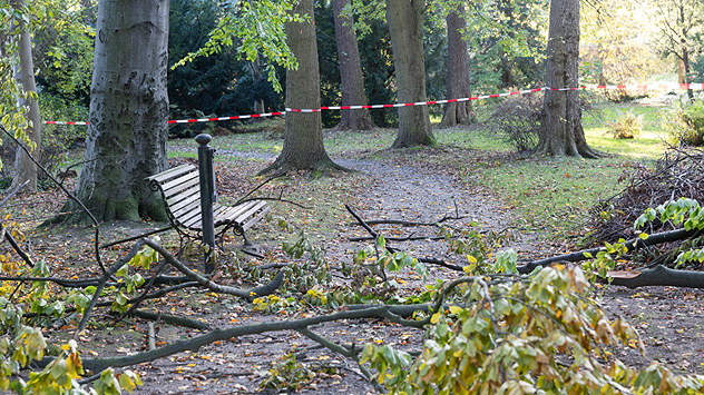
Fallen tree branches and green leaves cover a woodland path beside a bench, with red and white safety tape cordoning off the area.
With trees yet to lose their leaves, there's an additional danger in strong winds.

Storms Austen and Boelo are set to bring severe gales and heavy rain. There's plenty to do to prepare if you are in a warning area.

Adjust your outdoor plans

Planning an autumnal walk in the woods? Many trees still have their leaves, catching more wind. Even moderately strong gusts could cause branches to break or trees to fall. Avoid forests or other heavily wooded areas until the storm passes.

Prepare your garden

Bring loose items such as flowerpots, garden furniture, and parasols indoors, or secure them firmly. Don't forget your wheelie bins! Check that fences, garden gates, and other potentially loose structures are properly secured.

Remember the car and balcony

If you live in an apartment, check your balcony for anything that could blow away. During stormy weather, avoid parking your car beneath large trees, as falling branches can cause considerable damage.

Keep an eye on the WindRadar regularly over the coming days as Austen and Boelo move through.

Weather & Radar editorial team

More on the topic

Winds grow and rain spreads Wednesday. Prelude to Austen. . . Wednesday, 21 October 2026
Split weather map showing strong winds up to 40 mph across southern Britain and blue rain bands over Scotland, Ireland and England, with warning symbols.
Wednesday, 21 October 2026

Prelude to Austen

Winds grow and rain spreads Wednesday
Where do our storm names come from?. Austen possible this week. . . Monday, 19 October 2026
Lightning strikes beneath dark storm clouds over fields, with warning signs for thunderstorms and strong winds shown in foreground.
Monday, 19 October 2026

Austen possible this week

Where do our storm names come from?
Severe flooding in the south of France. Roads become rivers. . . Wednesday, 21 October 2026
Weather radar shows heavy rainfall over southern France, northern Italy, Corsica and Sardinia. A warning symbol indicates a risk of flooding.
Wednesday, 21 October 2026

Roads become rivers

Severe flooding in the south of France
All weather news

This might also interest you

Long-term trends need a pinch of salt. 40 °C in July?. . . Tuesday, 30 June 2026
Temperature radar of 2022 heatwave where the all-time temperature record in the UK was set. Warning symbol overlain.
Tuesday, 30 June 2026

40 °C in July?

Long-term trends need a pinch of salt
Bright and warm conditions take hold. Spring-like outlook. . . Thursday, 23 April 2026
Split UK map showing warm temperatures up to 21 degrees in orange on the left and clear sunny conditions with temperatures from 12 to 18 degrees on the right, with sun icons across the country.
Thursday, 23 April 2026

Spring-like outlook

Bright and warm conditions take hold
Super Typhoon Bavi threatens Taiwan. Up to 1,000 mm of rain. . . Wednesday, 8 July 2026
The image shows an intense tropical cyclone over the western Pacific, east of Taiwan and the Philippines. The centre of the system is depicted as a light purple and white vortex with a clearly visible eye, surrounded by a ring of red and orange areas indicating the strongest wind speeds. A white arrow marks the typhoon’s predicted track towards the north-west, in the direction of Taiwan. To the west of the storm lie the Philippines, with the cities of Manila and Cebu; to the north of these lies Taiwan, with Taipei. Further west, the Chinese coast, including Hong Kong, and parts of Vietnam can be seen. The coloured wind map shows predominantly green areas outside the storm’s core, indicating significantly weaker winds. White streamlines illustrate the typhoon’s anti-clockwise circulation in the Northern Hemisphere. The highest wind speeds are concentrated around the eye of the cyclone.
Wednesday, 8 July 2026

Up to 1,000 mm of rain

Super Typhoon Bavi threatens Taiwan
All articles
Weather & Radar

Weather & Radar is also available on

Google Play StoreApp Store

Company

Contact us Privacy Policy Legal info Accessibility statement

Services

Uploader

Socials

facebooktwittertikToklinkList