Home
Weather London
WeatherRadar
RainfallRadar
TemperatureRadar
WindRadar
LightningRadar
Weather News
Editor's Pick
Discover the app
Weather widget
Contact us
Apps
Career
    Home / Editor's Pick /

    The second warmest May on record – early heatwave in Europe

12:00
10 June 2026

Early heatwave in Europe
The second warmest May on record

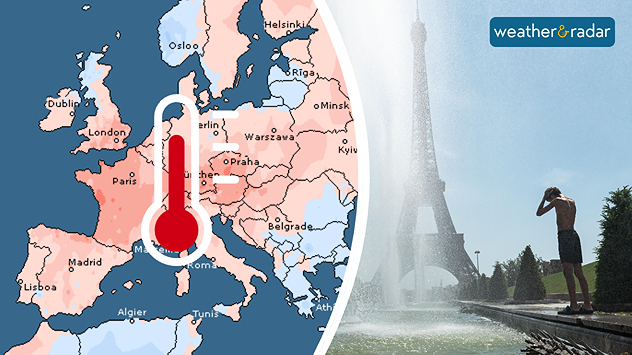
Split image showing a European temperature anomaly map with widespread warmer-than-average conditions on the left and a poerson cooling off beside a fountain near the Eiffel Tower during hot weather on the right.
May was unusually warm across Europe: in Paris, with temperatures reaching 35 degrees, any relief from the heat was welcome. - © picture alliance

May 2026 was the second-warmest May on record globally since measurements began. This is according to data from the EU’s Copernicus Climate Change Service.

In Europe in particular, an unusually early and intense heatwave led to numerous temperature records being broken.

In Portugal, the UK, and Ireland, new temperature records for May were set and it has already been extremely hot in France and Spain as well.

This early heatwave is in line with the long-term trend of rapid warming in Europe, with more frequent and intense heatwaves. In addition, the Alpine region and parts of Eastern Europe and the Balkans were affected by severe drought.

Spring records for England & Walesread more

The heatwave is also affecting the oceans

It was not only the western Mediterranean and the eastern Atlantic that were unusually warm, but the oceans worldwide.

In the tropical Pacific, the high sea surface temperatures point to the development of an El Niño, which could lead to extreme weather conditions worldwide in the coming months.

Niklas Weise

More on the topic

Severe weather in the south of France. Holiday spots affected. . . Monday, 19 October 2026
A severe weather warning for heavy rain has been issued for the south of France.
Monday, 19 October 2026

Holiday spots affected

Severe weather in the south of France
Storm Austen approaches. What to expect tonight. . . Thursday, 22 October 2026
Split image showing a wind map with 65 mph near Brest and a swirling storm south of England, beside a man wearing glasses and holding a microphone.
Thursday, 22 October 2026

What to expect tonight

Storm Austen approaches
Winds grow and rain spreads Wednesday. Prelude to Austen. . . Wednesday, 21 October 2026
Split weather map showing strong winds up to 40 mph across southern Britain and blue rain bands over Scotland, Ireland and England, with warning symbols.
Wednesday, 21 October 2026

Prelude to Austen

Winds grow and rain spreads Wednesday
All weather news

This might also interest you

A frozen start to the weekend. Icy conditions. . . Friday, 13 February 2026
UK temperature map dated 14.02 showing widespread subzero values in blue shading, with readings such as −4 in Glasgow, −3 in Dublin, and −2 in London, alongside a blue thermometer icon.
Friday, 13 February 2026

Icy conditions

A frozen start to the weekend
Storm Chandra makes impact. Severe gales & heavy rain. . . Tuesday, 27 January 2026
Split image showing strong winds over the UK on a forecast map and widespread rain and snow on a weather radar map.
Tuesday, 27 January 2026

Severe gales & heavy rain

Storm Chandra makes impact
New records for England and Wales. Broken again tomorrow?. . . Thursday, 25 June 2026
Temperature map of southwest Britain on 25.06 showing extreme heat across southern Wales and southwest England, with Bute Park in Cardiff highlighted at 34.2°C and Yeovilton at 36.4°C amid widespread deep red heat zones.
Thursday, 25 June 2026

Broken again tomorrow?

New records for England and Wales
All articles
Weather & Radar

Weather & Radar is also available on

Google Play StoreApp Store

Company

Contact us Privacy Policy Legal info Accessibility statement

Services

Uploader

Socials

facebooktwittertikToklinkList