Home
Weather London
WeatherRadar
RainfallRadar
TemperatureRadar
WindRadar
LightningRadar
Weather News
Editor's Pick
Discover the app
Weather widget
Contact us
Apps
Career
    Home / Editor's Pick /

    Above-average warmth - Spring records for England & Wales

08:00
2 June 2026

Above-average warmth
Spring records for England & Wales

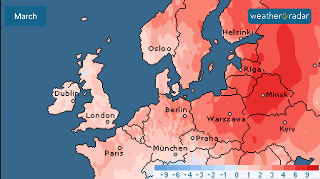
March temperature anomaly map of Europe showing widespread above-average temperatures in shades of red, strongest across eastern Europe and the Baltic region, with smaller anomalies over western Europe and the UK and Ireland.
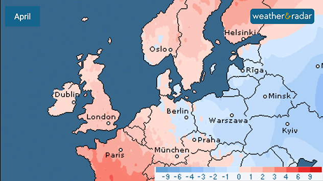
April temperature anomaly map of Europe showing warmer-than-average conditions in western Europe and Scandinavia in light red shades, while eastern Europe displays cooler-than-average anomalies in blue tones.
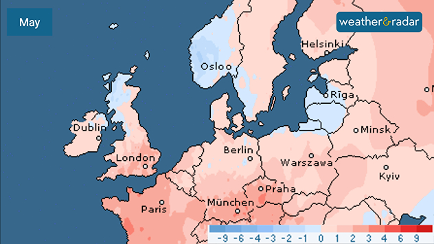
May temperature anomaly map of Europe showing mostly warmer-than-average conditions in light red shades across western and central Europe, with cooler blue anomalies over parts of the UK, Ireland, Scandinavia, and eastern Europe.
1/3
March's temperature anomaly map shows widespread above-average heat.

Spring has entered the history books as the warmest on record in England and Wales, becoming the third warmest across the UK.

Aided by May's late heatwave, with six conscutive days of temperatures over 30 °C, England and Wales saw the warmest spring season for mean temperature.

All three spring months also sit inside the top ten warmest for the UK since records began in 1884.

In England, this marks the third consecutive warmest spring with a mean temperature of 10.41 °C, beating the 2025 record of 10.23 °C.

Wales saw a mean temperature of 9.73 °C while Northern Ireland saw the sixth warmest season and Scotland the eighth, all combining for the third hottest spring for the UK as a whole.

Compounding the wamth was below-average rainfall, finishing 14% below the long-term spring average, though sunshine hours were above-average for all four countries.

Ryan Hathaway
More on the topic
Severe weather spreads across Europe. Lightning, hail, gales. . . Wednesday, 15 July 2026
Split image showing a dramatic supercell thunderstorm with dark rotating clouds over open countryside on the left, and a severe thunderstorm warning map on the right highlightning elevated storm risk across parts of central Europe, including northern Italy, Switzerland, eastern France, and southern Germany.
Wednesday, 15 July 2026

Lightning, hail, gales

Severe weather spreads across Europe
The monsoon has India firmly in its grip. Severe thunderstorms. . . Thursday, 9 July 2026
Satellite map of South Asia showing the weather situation over India. An arrow marks a low-pressure system over western and central India, which is causing heavy showers and thunderstorms. Thick clouds and rainfall extend across large parts of India as far as the Himalayas and into Bangladesh. Over Pakistan and south-eastern Iran, however, it is mainly sunny and hot, with temperatures exceeding 40 degrees.
Thursday, 9 July 2026

Severe thunderstorms

The monsoon has India firmly in its grip
Marine heatwave could affect our weather too. Wetter days to come?. . . Wednesday, 15 July 2026
Wednesday, 15 July 2026

Wetter days to come?

Marine heatwave could affect our weather too
All weather news
This might also interest you
Flooding, gales, and heavy snow. Storm Chandra. . . Tuesday, 27 January 2026
Split image showing aerial flooding in a town with muddy water covering roads on the left, and a rural road on the right blocked by heavy snowfall with vans stopped and a person walking in snow.
Tuesday, 27 January 2026

Storm Chandra

Flooding, gales, and heavy snow
Super Typhoon Bavi threatens Taiwan. Up to 1,000 mm of rain. . . Wednesday, 8 July 2026
The image shows an intense tropical cyclone over the western Pacific, east of Taiwan and the Philippines. The centre of the system is depicted as a light purple and white vortex with a clearly visible eye, surrounded by a ring of red and orange areas indicating the strongest wind speeds. A white arrow marks the typhoon’s predicted track towards the north-west, in the direction of Taiwan. To the west of the storm lie the Philippines, with the cities of Manila and Cebu; to the north of these lies Taiwan, with Taipei. Further west, the Chinese coast, including Hong Kong, and parts of Vietnam can be seen. The coloured wind map shows predominantly green areas outside the storm’s core, indicating significantly weaker winds. White streamlines illustrate the typhoon’s anti-clockwise circulation in the Northern Hemisphere. The highest wind speeds are concentrated around the eye of the cyclone.
Wednesday, 8 July 2026

Up to 1,000 mm of rain

Super Typhoon Bavi threatens Taiwan
New records for England and Wales. Broken again tomorrow?. . . Thursday, 25 June 2026
Temperature map of southwest Britain on 25.06 showing extreme heat across southern Wales and southwest England, with Bute Park in Cardiff highlighted at 34.2°C and Yeovilton at 36.4°C amid widespread deep red heat zones.
Thursday, 25 June 2026

Broken again tomorrow?

New records for England and Wales
All articles
Weather & Radar

Weather & Radar is also available on

Google Play StoreApp Store

Company

Contact us Privacy Policy Legal info Accessibility statement

Services

Uploader

Socials

facebooktwittertikToklinkList