Home
Weather London
WeatherRadar
RainfallRadar
TemperatureRadar
WindRadar
LightningRadar
Weather News
Editor's Pick
Discover the app
Weather widget
Contact us
Apps
Career
    Home / Editor's Pick /

    Sunday peak - UV levels soar over Bank Holiday weekend

08:00
20 May 2026

Sunday peak
UV levels soar over Bank Holiday weekend

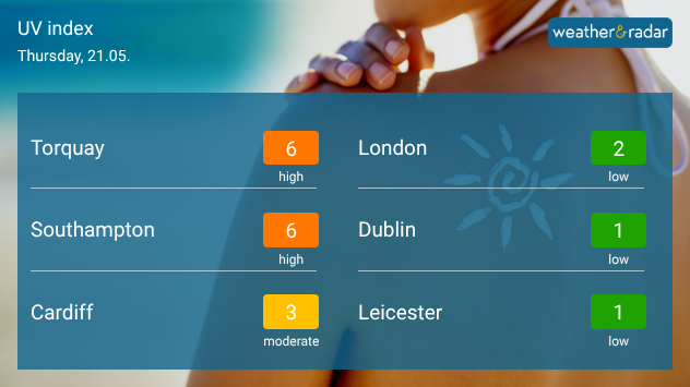
UV index forecast graphic for Thursday 21.05 showing high UV levels of 6 in Torquay and Southampton, moderate levels in Cardiff, and low UV levels in London, Dublin, and Leicester.
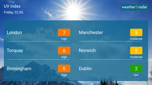
UV index graphic for Friday 22.05 showing high UV levels in London, Torquay, and Birmingham, moderate levels in Manchester and Norwich, and low levels in Dublin beneath a bright sunlit sky.
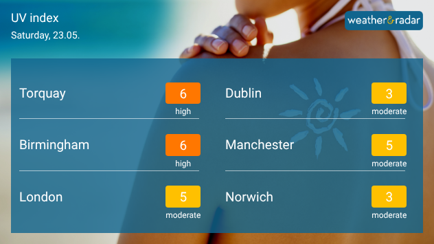
UV index forecast graphic for Saturday 23.05 showing high UV levels in Torquay and Birmingham, moderate levels in London, Manchester, Norwich, and Dublin, over a picture of a woman applying sunscreen.
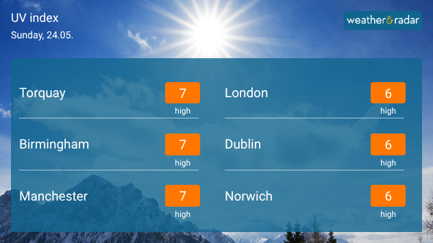
UV index forecast graphic for Sunday 24.05 showing high UV levels across the UK and Ireland, with values of 6 to 7 including Torquay, Birmingham, Manchester, London, and Norwich.
1/4
Across the southern coasts of England and Wales, UV starts to grow on Thursday.

Stocked up on sunscreen? You're going to need it with temperatures rising, the UV levels are on the up too!

From Thursday, high UV levels are already felt across southern England, turning more moderate into Wales. Friday marks the start of higher UV more broadly.

As temperatures peak over the Bank Holiday weekend, high to moderate levels are felt across much of the UK. Trending lower further north, it's important to regularly apply sunscreen and keep on top of where the UV level is at:

Ryan Hathaway
More on the topic
On the left is the temperature radar, showing high temperatures across Western Europe. On the right is the weather radar, showing a high-pressure system.
Tuesday, 26 May 2026

Summer weather in spring

Heatwave sets new records in Europe too
Temperature map of southeast England showing overnight low temperatures, with Kenley highlighted at 21.3°C and surrounding areas in yellow-orange shades indicating mild nighttime conditions.
Tuesday, 26 May 2026

May heatwave

Tropical night breaks overnight record
Split image showing a nighttime lightning strike beneath storm clouds on the left and a lightning detection map with dense storm activity across central England on the right.
Wednesday, 27 May 2026

Trickier than you think

Why it's hard to pinpoint thunderstorms
All weather news
This might also interest you
Split image showing aerial flooding in a town with muddy water covering roads on the left, and a rural road on the right blocked by heavy snowfall with vans stopped and a person walking in snow.
Tuesday, 27 January 2026

Storm Chandra

Flooding, gales, and heavy snow
Split image showing a person in a yellow jacket struggling against strong winds and heavy rain on a street at night on the left, and an Irish wind forecast map on the right with red and purple shading, gusts up to 75 mph, and a wind warning icon, divided by a curved white line.
Saturday, 24 January 2026

On this day...

Historic Storm Éowyn arrives
UK temperature map dated 14.02 showing widespread subzero values in blue shading, with readings such as −4 in Glasgow, −3 in Dublin, and −2 in London, alongside a blue thermometer icon.
Friday, 13 February 2026

Icy conditions

A frozen start to the weekend
All articles
Weather & Radar

Weather & Radar is also available on

Google Play StoreApp Store

Company

Contact us Privacy Policy Legal info Accessibility statement

Services

Uploader

Socials

facebooktwittertikToklinkList