Home
Weather London
WeatherRadar
RainfallRadar
TemperatureRadar
WindRadar
LightningRadar
Weather News
Editor's Pick
Discover the app
Weather widget
Contact us
Apps
Career
    Home / Weather News /

    Storm Chandra - Flooding, gales, and heavy snow

13:49
27 January 2026

Storm Chandra
Flooding, gales, and heavy snow

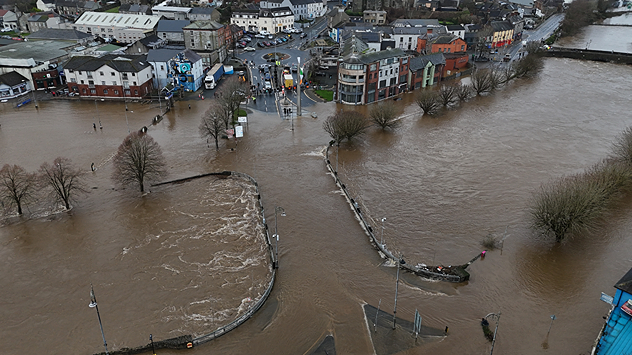
Aerial view of a town with rivers overflowed, brown floodwater covering roads, parks, and footpaths, surrounding buildings and trees.
The River Slaney burst its banks Tuesday morning, flooding Enniscorthy, Co. Wexford. - © picture alliance

As Storm Chandra passes through, surface flooding and rivers bursting their banks are being reported in southern Ireland and the UK, while it is heavy snow disrupting things further north.

In Co. Wexford, the River Slaney burst its banks in Enniscorthy, flooding the riverbanks, roads, and some vehicles. In York, the River Ouse has also overflown.

Elsewhere, the torrential rain has resulted in flooded roads impacting travel, with Devon and Somerset firefighters reporting that they have rescued people from 25 vehicles.

Snow is also an issue in Durham and further north in Scotland, particularly over higher ground.

Snowploughs have been deployed to ease road conditions, though the icy pavements still pose a risk to those on foot.

Meanwhile, new weather warnings for ice have been issued for Wednesday. These cover southern Scotland, central to eastern Wales, much of England (outside of the south-west), and Northern Ireland.

Ryan Hathaway
More on the topic
Split image showing a bright rainbow above a residential street on the left and a dramatic ocean sunrise with glowing clouds and reflections on the sea on the right.
Sunday, 24 May 2026

Your weather - Your shots

From unsettled to warm and toasty
Temperature map of southeast England showing overnight low temperatures, with Kenley highlighted at 21.3°C and surrounding areas in yellow-orange shades indicating mild nighttime conditions.
Tuesday, 26 May 2026

May heatwave

Tropical night breaks overnight record
Weather warning map of Wales and western Britain showing a yellow thunderstorm alert with lightning symbols, alongside a large warning triangle for lightning.
Wednesday, 27 May 2026

Wales & western England

Thunderstorm watch continues
All weather news
This might also interest you
Split weather map showing UK wind speeds in orange-red shades up to 40 mph on the left and warning levels in green-yellow on the right, with a central wind warning sign.
Wednesday, 22 October 2025

Warnings active

Storm Benjamin impacts the UK
Split image showing a person in a yellow jacket struggling against strong winds and heavy rain on a street at night on the left, and an Irish wind forecast map on the right with red and purple shading, gusts up to 75 mph, and a wind warning icon, divided by a curved white line.
Saturday, 24 January 2026

On this day...

Historic Storm Éowyn arrives
Illustration of white and yellow fireworks on a blue background.
Wednesday, 31 December 2025

Hello 2026

Happy New Year
All articles
Weather & Radar

Weather & Radar is also available on

Google Play StoreApp Store

Company

Contact us Privacy Policy Legal info Accessibility statement

Services

Uploader

Socials

facebooktwittertikToklinkList