Home
Weather London
WeatherRadar
RainfallRadar
TemperatureRadar
WindRadar
LightningRadar
Weather News
Editor's Pick
Discover the app
Weather widget
Contact us
Apps
Career
    Home / Weather News /

    Warnings active - Storm Benjamin impacts the UK

08:00
22 October 2025

Warnings active
Storm Benjamin impacts the UK

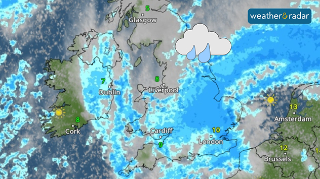
Weather radar map over the UK and Ireland showing widespread blue precipitation bands, cloud icon, and temperatures from 5°C in Glasgow to 13°C near Amsterdam.
Heavy rain spreads over the UK as Storm Benjamin passes by.

Storm Benjamin, named by Météo-France, will bring heavy rain and strong winds to parts of the UK to end the week.

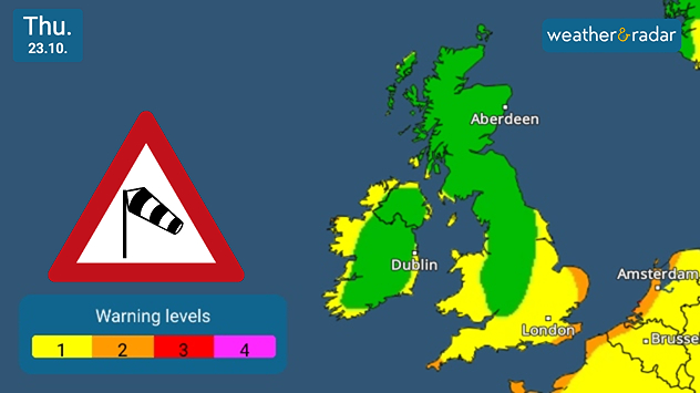
Warnings for both wind and rain are active for Thursday, although the worst of the system will be felt in Europe across France, Belgium, and the Netherlands.

For the UK, southern to south-east England can expect to feel the influence of Benjamin overnight from Wednesday. Up to 50 mm of rain could fall in some areas, with up to 30 mm expected more widely.

Weather map of the UK and Ireland dated Thursday 23 October showing green to yellow warning levels, with a wind warning sign and colour scale from level 1 to 4. Yellow warning seen along the coasts of Ireland, Wales, and parts of southern to eastern England, orange warnings along the east and south-east coastline of England and in the far south-west.
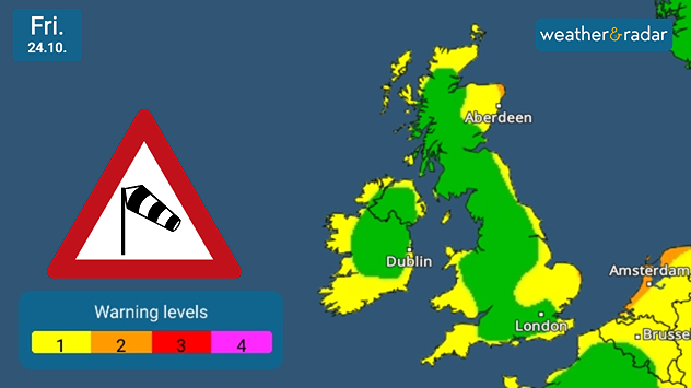
Weather map of the UK and Ireland dated Thursday 23 October showing green to yellow warning levels, with a wind warning sign and color scale from level 1 to 4. Yellow warnings seen across southern Ireland and coasts, eastern England, Wales, and eastern Scotland.
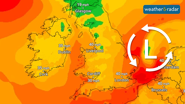
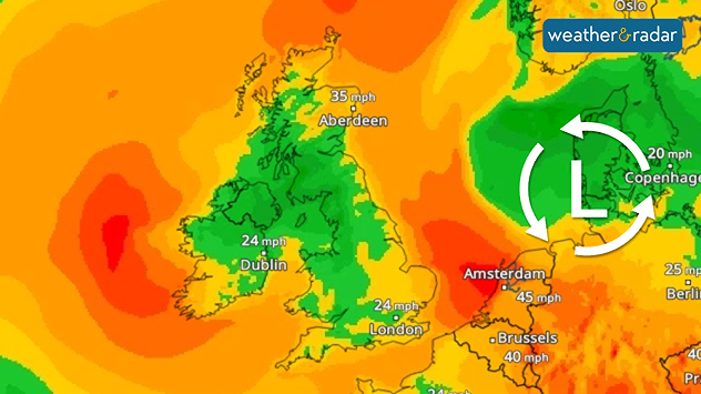
Map of the UK and nearby Europe showing wind speeds in mph with orange to red shading and a large rotating low-pressure symbol centred near the North Sea; highest speeds around London and Brussels.
Wind map of the UK and Western Europe with a low-pressure icon indicating Storm Benjamin centred over Denmark.
1/4
Wind warnings for Thursday.

As a result of the stormy weather, localised surface flooding and some wind damage is likely as gusts of up to 55 mph inland and up to 65 mph along the eastern English coastline are expected.

It is possible that some stronger gusts around 70 mph hit some coastal parts of Kent, Essex and Suffolk, though the exact development of the system is still unclear.

Activate severe weather warningsread also
Ryan Hathaway
More on the topic
A composite image showing the Temperature Radar and a drinking fountain. The Temperature Radar shows Thursday’s maximum temperatures of up to 37.8 degrees in France, whilst people use a fountain to cool off.
Friday, 29 May 2026

Up to 38 °C in France

Heatwave clocks more record temperatures
Temperature map of southeast England showing overnight low temperatures, with Kenley highlighted at 21.3°C and surrounding areas in yellow-orange shades indicating mild nighttime conditions.
Tuesday, 26 May 2026

May heatwave

Tropical night breaks overnight record
Split image showing a European weather map with low-pressyre system, temperature bands, and thunderstorm icon on the left, and a bright rainbow over green countryside and mountains on the right.
Wednesday, 27 May 2026

Early summer ends

A change in the weather is on the way
All weather news
This might also interest you
Illustration of white and yellow fireworks on a blue background.
Wednesday, 31 December 2025

Hello 2026

Happy New Year
Split image showing coastal sunset with layered lenticular clouds over rooftops and palm trees on the left, and a green valley with river and hills under soft daylight on the right.
Sunday, 19 April 2026

Your weather - Your shots

Seasonal warmth between spring thunder
Weather graphic showing rain and wind fields over the Canary Islands and a central warning symbol.
Friday, 12 December 2025

Storm and rain

Turbulent weather in the Canary Islands
All articles
Weather & Radar

Weather & Radar is also available on

Google Play StoreApp Store

Company

Contact us Privacy Policy Legal info Accessibility statement

Services

Uploader

Socials

facebooktwittertikToklinkList