Home
Weather London
WeatherRadar
RainfallRadar
TemperatureRadar
WindRadar
LightningRadar
Weather News
Editor's Pick
Discover the app
Weather widget
Contact us
Apps
Career
    Home / Editor's Pick /

    Storm Claudia - Heavy rain likely to bring disruption

09:00
13 November 2025

Storm Claudia
Heavy rain likely to bring disruption

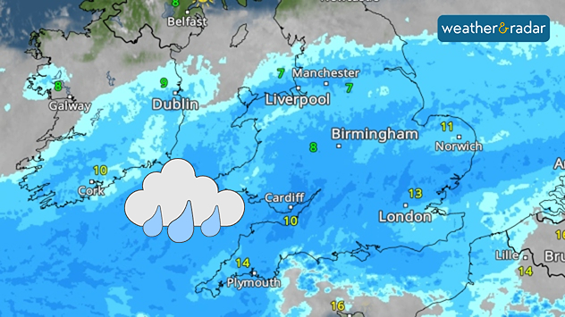
Weather radar showing widespread heavy rain across Wales, England, and south-east Ireland.
Friday looks to be a complete washout for many.

Continuous heavy rainfall on Friday is likely to bring widespread disruption to end the week, with flooding expected and warnings issued.

The large area of rain moves in on Thursday evening, and sits almost stationary throughout Friday, not easing until well into Saturday.

Flood risk

There are over 100 flood alerts active across England, primarily focused around the Midlands.

As a result, expect poor visibility on the roads, and flooding in those areas that sit under the rain band. Impacts will be particularly felt in south-east Wales, where up to 150 mm of rain is expected over higher grounds.

It won't just be the rain dampening the day, strong gusting winds of up to 60 mph (97 km/h) will arrive Friday evening in eastern Ireland and western Wales.

More widely between 35 (55) - 50 mph (80 km/h) across the UK and Ireland, these winds will be felt in Scotland too where the heavy rain will not reach.

These conditions are due to the influence of Storm Claudia, named by the Spanish Met Office, which is expected to deliver up to 200 mm of rainfall in Portugal and western Spain by the weekend.

Keep an eye on conditionsWeatherRadar
Ryan Hathaway
More on the topic
Heat becoming a bigger factor in drought. New study. . . Thursday, 23 July 2026
A hand holds dry, dusty earth above a parched field. The ground is cracked and covered with plant debris – a sign of prolonged drought.
Thursday, 23 July 2026

New study

Heat becoming a bigger factor in drought
Rain returns to end dry spell in places. Jet stream delivery. . . Thursday, 23 July 2026
Split weather graphic showing widespread showers across the UK and Ireland on the left, and a wind forecast map on the right with a windsock icon and gusts of 25 to 35 mph, highlighting breezy conditions across the two countries.
Thursday, 23 July 2026

Jet stream delivery

Rain returns to end dry spell in places
Parts of England inching towards drought. Low rivers & reservoirs. . . Wednesday, 22 July 2026
People relaxing in a park during hot weather ,with one person sunbathing on dry yellow grass beneath large leafy trees under a blue sky with scattered fair-weather clouds.
Wednesday, 22 July 2026

Low rivers & reservoirs

Parts of England inching towards drought
All weather news
This might also interest you
Turbulent weather in the Canary Islands. Storm and rain. . . Friday, 12 December 2025
Weather graphic showing rain and wind fields over the Canary Islands and a central warning symbol.
Friday, 12 December 2025

Storm and rain

Turbulent weather in the Canary Islands
Super Typhoon Bavi threatens Taiwan. Up to 1,000 mm of rain. . . Wednesday, 8 July 2026
The image shows an intense tropical cyclone over the western Pacific, east of Taiwan and the Philippines. The centre of the system is depicted as a light purple and white vortex with a clearly visible eye, surrounded by a ring of red and orange areas indicating the strongest wind speeds. A white arrow marks the typhoon’s predicted track towards the north-west, in the direction of Taiwan. To the west of the storm lie the Philippines, with the cities of Manila and Cebu; to the north of these lies Taiwan, with Taipei. Further west, the Chinese coast, including Hong Kong, and parts of Vietnam can be seen. The coloured wind map shows predominantly green areas outside the storm’s core, indicating significantly weaker winds. White streamlines illustrate the typhoon’s anti-clockwise circulation in the Northern Hemisphere. The highest wind speeds are concentrated around the eye of the cyclone.
Wednesday, 8 July 2026

Up to 1,000 mm of rain

Super Typhoon Bavi threatens Taiwan
Historic Storm Éowyn arrives. On this day.... . . Saturday, 24 January 2026
Split image showing a person in a yellow jacket struggling against strong winds and heavy rain on a street at night on the left, and an Irish wind forecast map on the right with red and purple shading, gusts up to 75 mph, and a wind warning icon, divided by a curved white line.
Saturday, 24 January 2026

On this day...

Historic Storm Éowyn arrives
All articles
Weather & Radar

Weather & Radar is also available on

Google Play StoreApp Store

Company

Contact us Privacy Policy Legal info Accessibility statement

Services

Uploader

Socials

facebooktwittertikToklinkList