Home
Weather London
WeatherRadar
RainfallRadar
TemperatureRadar
WindRadar
LightningRadar
Weather News
Editor's Pick
Discover the app
Weather widget
Contact us
Apps
Career
    Home / Editor's Pick /

    Local phenomenon - Cheshire Gap produces shower funnel

09:00
9 September 2026

Local phenomenon
Cheshire Gap produces shower funnel

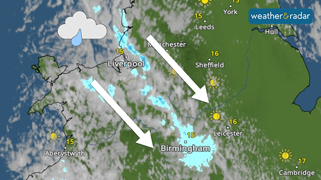
Weather map showing showers moving southeast from Liverpool toward Birmingham, driven by Cheshire Gap convergence across central England.
A clear passage of showers highlights the Cheshire Gap phenomenon.

Showers are being funnelled through north-western England Wednesday morning thanks to a local phenomenon in the area.

Known as Cheshire Gap convergence, the local geography of the Cheshire Plain can result in more unstable weather compared to surrounding areas.

This is mostly thanks to Snowdonia and the Clwydian Hills to the west and the Peak District and South Pennines to the east creating what is called a channeling effect.

The northwesterly flow picks up moisture from the nearby Irish Sea and is then being deflected by the nearby mountains.

Eventually, the airflow is forced to flow through the lowland gap of the Cheshire Gap, producing towering clouds and bands of showers as the converging flow of air rises.

In winter, heavy snow can develop if the air is sufficiently cold and unstable, with some towns and cities seeing several centimetres of snow in just a few hours, while nearby areas remain dry.

Ryan Hathaway
More on the topic
More rain needed to ease drought. Reservoirs still falling. . . Tuesday, 8 September 2026
Aerial view of a depleted reservoir with exposed banks and a narrow winding stream through the dry basin, surrounded by green hills and roads.
Tuesday, 8 September 2026

Reservoirs still falling

More rain needed to ease drought
Autumn colours light the skies. Your weather - Your shots. . . Sunday, 13 September 2026
Split image showing a fiery red-orange sunset over a rural road and fields beside a golden sea sunset with a silhouetted seabird in flight.
Sunday, 13 September 2026

Your weather - Your shots

Autumn colours light the skies
Autumn arrives with vivid colour. Your weather - Your shots. . . Sunday, 6 September 2026
Split image showing peach-lit textured clouds above silhouetted trees and golden cumulus clouds reflected in a calm canal lined with boats.
Sunday, 6 September 2026

Your weather - Your shots

Autumn arrives with vivid colour
All weather news
This might also interest you
A stormy week in the skies above. Your weather - Your shots. . . Sunday, 30 August 2026
Split image showing lightning branching beneath dark storm clouds above rooftops on the left and an orange-pink sunset over a calm sea on the right.
Sunday, 30 August 2026

Your weather - Your shots

A stormy week in the skies above
Storm Chandra makes impact. Severe gales & heavy rain. . . Tuesday, 27 January 2026
Split image showing strong winds over the UK on a forecast map and widespread rain and snow on a weather radar map.
Tuesday, 27 January 2026

Severe gales & heavy rain

Storm Chandra makes impact
A frozen start to the weekend. Icy conditions. . . Friday, 13 February 2026
UK temperature map dated 14.02 showing widespread subzero values in blue shading, with readings such as −4 in Glasgow, −3 in Dublin, and −2 in London, alongside a blue thermometer icon.
Friday, 13 February 2026

Icy conditions

A frozen start to the weekend
All articles
Weather & Radar

Weather & Radar is also available on

Google Play StoreApp Store

Company

Contact us Privacy Policy Legal info Accessibility statement

Services

Uploader

Socials

facebooktwittertikToklinkList