Home
Weather London
WeatherRadar
RainfallRadar
TemperatureRadar
WindRadar
LightningRadar
Weather News
Editor's Pick
Discover the app
Weather widget
Contact us
Apps
Career
    Home / Editor's Pick /

    Severe weather in Spain and Greece claims lives

10:28
5 October 2026

Streets under water
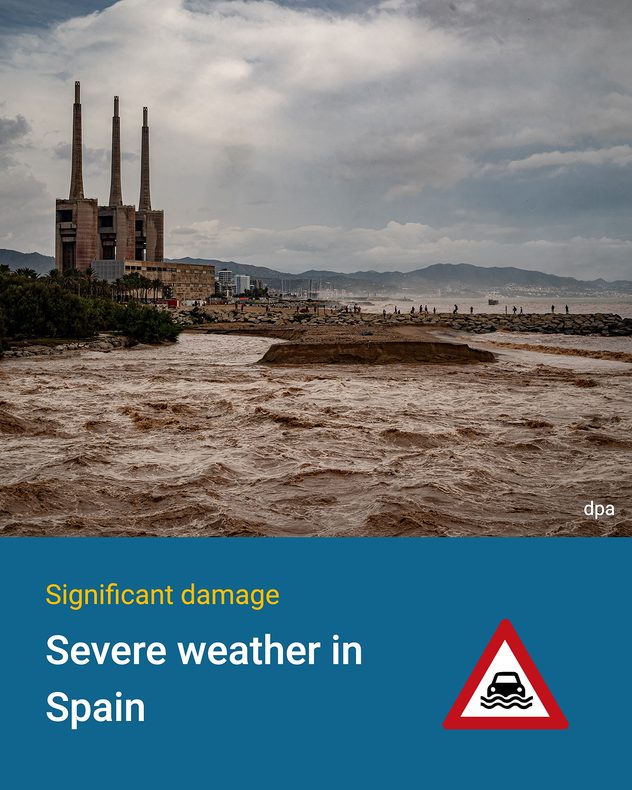
Severe weather in Spain and Greece

Heavy rain and thunderstorms have caused widespread damage in Spain and Greece. The north-east of Spain, around Barcelona, was particularly hard hit. In some places there, more than 200 mm of rain fell in just 24 hours.

The Besòs river near Barcelona, which is severely swollen, is carrying brown floodwater and large quantities of branches and other debris.
Following the heavy rainfall, local residents are clearing mud and water from a road in the Barcelona area.
A road near Barcelona is covered in mud and water following the storms.
Following the floods, mud and water have left a kitchen in the Barcelona area heavily soiled and damaged.
1/5

That is almost twice as much as is normally recorded there throughout the whole of October. Rivers burst their banks and numerous roads were flooded. At least three people lost their lives.

Even more rain in Crete

Even greater amounts of rain fell in Crete. Locally, up to 500 mm fell there – which is roughly the same amount of water as would fit into three full bath tubs per square metre.

Roads were washed away, houses and farmland were damaged, and there were power cuts in many places. On Rhodes, a German holidaymaker was also killed by a lightning strike.

The weather situation in Greece has now settled down. In parts of Spain, however, conditions are set to remain unsettled over the next few days. Anyone travelling there should keep an eye on the weather radar.

New severe thunderstorms in SpainWeatherRadar
Weather & Radar editorial team

More on the topic

Brazil: A spring full of storms. Rain and flooding. . . Friday, 13 November 2026
Split. On the left, a weather map of Brazil showing clouds, rain and lightning. On the right, a thundercloud
Friday, 13 November 2026

Rain and flooding

Brazil: A spring full of storms
Meteor shower peaks with mixed visibility. Better view Thursday. . . Wednesday, 11 November 2026
Split image showing a UK weather map with temperatures of 0–7°C and snow showers in Scotland, beside a bright meteor streak in a starry night sky.
Wednesday, 11 November 2026

Better view Thursday

Meteor shower peaks with mixed visibility
Why forecasting snow is so tricky. When will snow return?. . . Tuesday, 17 November 2026
Split image showing pink snow bands across the Scottish Highlands on a weather map, beside snow-covered orange leaves on a branch.
Tuesday, 17 November 2026

When will snow return?

Why forecasting snow is so tricky
All weather news

This might also interest you

A frozen start to the weekend. Icy conditions. . . Friday, 13 February 2026
UK temperature map dated 14.02 showing widespread subzero values in blue shading, with readings such as −4 in Glasgow, −3 in Dublin, and −2 in London, alongside a blue thermometer icon.
Friday, 13 February 2026

Icy conditions

A frozen start to the weekend
A stormy week in the skies above. Your weather - Your shots. . . Sunday, 30 August 2026
Split image showing lightning branching beneath dark storm clouds above rooftops on the left and an orange-pink sunset over a calm sea on the right.
Sunday, 30 August 2026

Your weather - Your shots

A stormy week in the skies above
Super Typhoon Bavi threatens Taiwan. Up to 1,000 mm of rain. . . Wednesday, 8 July 2026
The image shows an intense tropical cyclone over the western Pacific, east of Taiwan and the Philippines. The centre of the system is depicted as a light purple and white vortex with a clearly visible eye, surrounded by a ring of red and orange areas indicating the strongest wind speeds. A white arrow marks the typhoon’s predicted track towards the north-west, in the direction of Taiwan. To the west of the storm lie the Philippines, with the cities of Manila and Cebu; to the north of these lies Taiwan, with Taipei. Further west, the Chinese coast, including Hong Kong, and parts of Vietnam can be seen. The coloured wind map shows predominantly green areas outside the storm’s core, indicating significantly weaker winds. White streamlines illustrate the typhoon’s anti-clockwise circulation in the Northern Hemisphere. The highest wind speeds are concentrated around the eye of the cyclone.
Wednesday, 8 July 2026

Up to 1,000 mm of rain

Super Typhoon Bavi threatens Taiwan
All articles
Weather & Radar

Weather & Radar is also available on

Google Play StoreApp Store

Company

Contact us Privacy Policy Legal info Accessibility statement

Services

Uploader

Socials

facebooktwittertikToklinkList