Home
Weather London
WeatherRadar
RainfallRadar
TemperatureRadar
WindRadar
LightningRadar
Weather News
Editor's Pick
Discover the app
Weather widget
Contact us
Apps
Career
    Home / Editor's Pick /

    When will snow return? Why snow forecasts can be unreliable

08:00
17 November 2026

When will snow return?
Why forecasting snow is so tricky

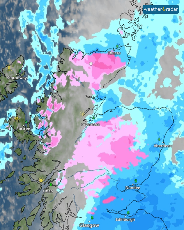
Weather radar showing widespread pink snow bands across northern and central Scotland, with blue rain areas near Aberdeen and Edinburgh and temperatures of 3–6°C.
Pinks on the WeatherRadar show snow!

Snow and sleet showers fell across the Highlands this weekend, but forecasting snow is more difficult than you might think. Predictions beyond three days are particularly unreliable, as snow depends on several factors, including temperature, altitude and location.

Snow becomes more likely when temperatures fall below 2°C, with sub-zero conditions often producing drier, powdery snow. However, whether snow reaches the ground depends on the temperature and humidity of the air it falls through.

Most precipitation begins as snow high in the atmosphere. If it passes through warmer air, it can melt into rain or sleet, even when temperatures at ground level are low enough for snow.

Altitude also plays a role, with temperatures generally decreasing as elevation increases. This explains why hills and mountains often experience more snowfall than lower-lying areas. Cities and coastal locations also tend to be warmer, meaning conditions can vary significantly over short distances.

Wind direction can quickly change the likelihood of snowfall too. Easterly winds often bring colder, drier air during winter, increasing the chance of snow in eastern areas. Changes in wind direction also shift the freezing level, while heavy precipitation can sometimes lower it enough to turn rain into snow.

Finally, the path of a weather system can determine where snow falls. Low-pressure systems often carry milder air, so even a slight shift in their track can make the difference between rain, sleet and snow. The best way to keep track is to watch the WeatherRadar this winter and look for the tell-tale signs of pink!

Ryan Hathaway

More on the topic

Storm hits the Iberian Peninsula. Hurricane-force gusts. . . Wednesday, 11 November 2026
WindRadar showing a storm warning symbol and areas of strong winds over Portugal, southern Spain and Morocco.
Wednesday, 11 November 2026

Hurricane-force gusts

Storm hits the Iberian Peninsula
A foggy start to a frosty end. Your weather - Your shots. . . Sunday, 15 November 2026
Split image showing a calm lake shrouded in dense gray fog beside terraced houses beneath textured purple-gray sunset clouds.
Sunday, 15 November 2026

Your weather - Your shots

A foggy start to a frosty end
First widespread frost of the season. Freezing evenings. . . Wednesday, 11 November 2026
Temperature map showing -3°C near Cardiff, -2°C in Dublin, -1°C in Glasgow and Liverpool, and 2°C near Aberdeen and London, with a blue thermometer.
Wednesday, 11 November 2026

Freezing evenings

First widespread frost of the season
All weather news

This might also interest you

Bright and warm conditions take hold. Spring-like outlook. . . Thursday, 23 April 2026
Split UK map showing warm temperatures up to 21 degrees in orange on the left and clear sunny conditions with temperatures from 12 to 18 degrees on the right, with sun icons across the country.
Thursday, 23 April 2026

Spring-like outlook

Bright and warm conditions take hold
Super Typhoon Bavi threatens Taiwan. Up to 1,000 mm of rain. . . Wednesday, 8 July 2026
The image shows an intense tropical cyclone over the western Pacific, east of Taiwan and the Philippines. The centre of the system is depicted as a light purple and white vortex with a clearly visible eye, surrounded by a ring of red and orange areas indicating the strongest wind speeds. A white arrow marks the typhoon’s predicted track towards the north-west, in the direction of Taiwan. To the west of the storm lie the Philippines, with the cities of Manila and Cebu; to the north of these lies Taiwan, with Taipei. Further west, the Chinese coast, including Hong Kong, and parts of Vietnam can be seen. The coloured wind map shows predominantly green areas outside the storm’s core, indicating significantly weaker winds. White streamlines illustrate the typhoon’s anti-clockwise circulation in the Northern Hemisphere. The highest wind speeds are concentrated around the eye of the cyclone.
Wednesday, 8 July 2026

Up to 1,000 mm of rain

Super Typhoon Bavi threatens Taiwan
A frozen start to the weekend. Icy conditions. . . Friday, 13 February 2026
UK temperature map dated 14.02 showing widespread subzero values in blue shading, with readings such as −4 in Glasgow, −3 in Dublin, and −2 in London, alongside a blue thermometer icon.
Friday, 13 February 2026

Icy conditions

A frozen start to the weekend
All articles
Weather & Radar

Weather & Radar is also available on

Google Play StoreApp Store

Company

Contact us Privacy Policy Legal info Accessibility statement

Services

Uploader

Socials

facebooktwittertikToklinkList