Home
Weather London
WeatherRadar
RainfallRadar
TemperatureRadar
WindRadar
LightningRadar
Weather News
Editor's Pick
Discover the app
Weather widget
Contact us
Apps
Career
    Home / Editor's Pick /

    Risk in northern England - Flood alerts after heavy showers

08:35
20 August 2026

Risk in northern England
Flood alerts after heavy showers

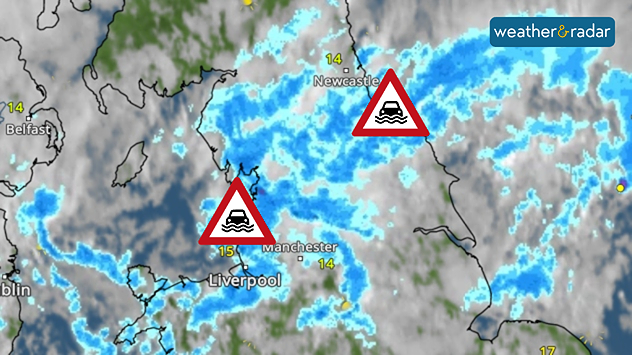
Weather radar map showing heavy rain across northern England around Liverpool, Manchester and Newcastle, with flood warning symbols highlighting areas at risk.
Flood alerts return for the first time in months as heavy showers spread.

Flood alerts have been issued in parts of northern England amid the return of heavy showers falling over parched ground.

A total of five flood alerts, indicating flooding is possible, have been issued Thursday morning for parts of the north-east and north-west.

These cover the Crossens area of west Lancashire, Lower River Wear, Middlesborough Becks, the Rivers Derwent, Team, and Don, and the River Alt.

All alerts are the result of heavy showers causing rising river levels which threatens to burst banks.

Heavy showers in the affected areas continue, with up to 40 mm of rainfall possible in some areas in a few hours.

Understanding alerts

Flood alerts, warnings, and severe warnings are a live service and can update through the day. It's best to keep an eye on any alerts in your area as they can change at any time.

As rain falls over dry, parched ground, soil is unable to sufficiently absorb the water, leading to excessive run-off and flooding issues.

5 days ago
Ryan Hathaway
More on the topic
Lightning strikes in dry conditions. Positive earth flashes. . . Monday, 17 August 2026
On the left, massive thunderclouds are gathering at night, with several flashes of lightning streaking from them. On the right, a map shows the Ligurian coast near Genoa and Savona. Numerous coloured dots over the Ligurian Sea and along the coast indicate lightning activity.
Monday, 17 August 2026

Positive earth flashes

Lightning strikes in dry conditions
Severe weather risk in holiday spots. Hail and heavy rain. . . Wednesday, 19 August 2026
Split weather graphic showing intense thunderstorms and widespread lightning across northern Italy and Switzerland on the left, with severe warning zones from yellow to red around Milan and the southern Alps on the right.
Wednesday, 19 August 2026

Hail and heavy rain

Severe weather risk in holiday spots
Chance of thundery showers breaking out. Over the coming days. . . Tuesday, 18 August 2026
Split weather graphic showing a yellow thunderstorm warning across eastern England alongside radar with heavy showers and lightning near Sheffield, Leicester and East Anglia.
Tuesday, 18 August 2026

Over the coming days

Chance of thundery showers breaking out
All weather news
This might also interest you
Seasonal warmth between spring thunder. Your weather - Your shots. . . Sunday, 19 April 2026
Split image showing coastal sunset with layered lenticular clouds over rooftops and palm trees on the left, and a green valley with river and hills under soft daylight on the right.
Sunday, 19 April 2026

Your weather - Your shots

Seasonal warmth between spring thunder
Turbulent weather in the Canary Islands. Storm and rain. . . Friday, 12 December 2025
Weather graphic showing rain and wind fields over the Canary Islands and a central warning symbol.
Friday, 12 December 2025

Storm and rain

Turbulent weather in the Canary Islands
Storm Chandra makes impact. Severe gales & heavy rain. . . Tuesday, 27 January 2026
Split image showing strong winds over the UK on a forecast map and widespread rain and snow on a weather radar map.
Tuesday, 27 January 2026

Severe gales & heavy rain

Storm Chandra makes impact
All articles
Weather & Radar

Weather & Radar is also available on

Google Play StoreApp Store

Company

Contact us Privacy Policy Legal info Accessibility statement

Services

Uploader

Socials

facebooktwittertikToklinkList