Home
Weather London
WeatherRadar
RainfallRadar
TemperatureRadar
WindRadar
LightningRadar
Weather News
Editor's Pick
Discover the app
Weather widget
Contact us
Apps
Career
    Home / Editor's Pick /

    Over the coming days - Chance of thundery showers breaking out

14:17
18 August 2026

Over the coming days
Chance of thundery showers breaking out

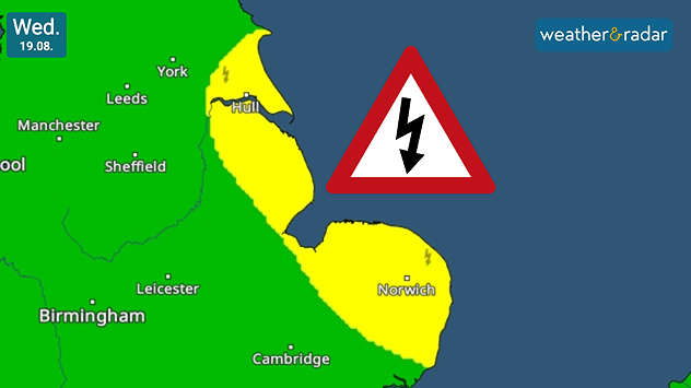
Weather warning map for Wednesday 19.08 showing yellow thunderstorm risk areas along eastern England from near Hull to Norwich, with a lightning warning symbol.
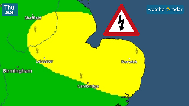
Weather warning map for Thursday 20.08 showing a broad yellow thunderstorm risk area across eastern England, including Leicester, Cambridge and Norwich, with a lightning warning symbol.
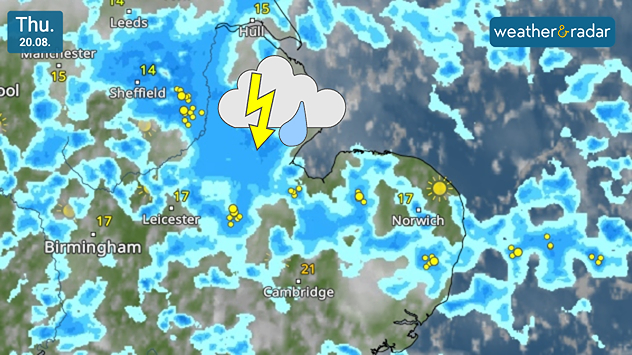
Weather radar map for Thursday 20.08 showing widespread showers and thunderstorms across eastern England, with lightning strikes around Sheffield, Leicester, Cambridge and Norwich.
1/3
Warnings in the app hug the east coast of England initially.

Parts of eastern England may see outbreaks of thundery showers from Wednesday with our own warnings covering the east coast before moving more inland.

On Wednesday, the risk of outbreaks rests predominantly across the east coast of England, in a stretch from Bridlington to Leiston, north-east of Ipswich which is not covered.

By Thursday, the risk extends into the East Midlands, as far as Derbyshire as continued showers hold the potential to bring short-lived thunder and lightning.

Ryan Hathaway
More on the topic
Drought brings flash flood risks. As rain returns. . . Wednesday, 19 August 2026
Weather radar map of the UK and Ireland showing widespread showers, with a rain icon and flood warning symbol highlighting the risk from rainfall.
Wednesday, 19 August 2026

As rain returns

Drought brings flash flood risks
Late-summer views as shooting stars fly. Your weather - Your shots. . . Sunday, 23 August 2026
Split image showing a meteor streaking through a star-filled night sky on the left and wispy white cirrus clouds sweeping across a vivid blue daytime sky on the right.
Sunday, 23 August 2026

Your weather - Your shots

Late-summer views as shooting stars fly
Damage in Germany after severe weather. Several tornadoes formed. . . Thursday, 20 August 2026
Split image: Weather map showing thunderstorms and a tornado symbol over western Germany. On the right, severe damage to buildings and rubble on a road can be seen.
Thursday, 20 August 2026

Several tornadoes formed

Damage in Germany after severe weather
All weather news
This might also interest you
Historic Storm Éowyn arrives. On this day.... . . Saturday, 24 January 2026
Split image showing a person in a yellow jacket struggling against strong winds and heavy rain on a street at night on the left, and an Irish wind forecast map on the right with red and purple shading, gusts up to 75 mph, and a wind warning icon, divided by a curved white line.
Saturday, 24 January 2026

On this day...

Historic Storm Éowyn arrives
A frozen start to the weekend. Icy conditions. . . Friday, 13 February 2026
UK temperature map dated 14.02 showing widespread subzero values in blue shading, with readings such as −4 in Glasgow, −3 in Dublin, and −2 in London, alongside a blue thermometer icon.
Friday, 13 February 2026

Icy conditions

A frozen start to the weekend
Turbulent weather in the Canary Islands. Storm and rain. . . Friday, 12 December 2025
Weather graphic showing rain and wind fields over the Canary Islands and a central warning symbol.
Friday, 12 December 2025

Storm and rain

Turbulent weather in the Canary Islands
All articles
Weather & Radar

Weather & Radar is also available on

Google Play StoreApp Store

Company

Contact us Privacy Policy Legal info Accessibility statement

Services

Uploader

Socials

facebooktwittertikToklinkList