Home
Weather London
WeatherRadar
RainfallRadar
TemperatureRadar
WindRadar
LightningRadar
Weather News
Editor's Pick
Discover the app
Weather widget
Contact us
Apps
Career
    Home / Editor's Pick /

    Drought brings flash flood risks as rain returns

08:57
19 August 2026

As rain returns
Drought brings flash flood risks

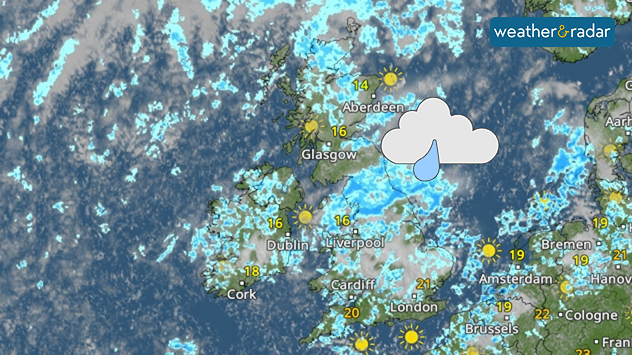
Weather radar map of the UK and Ireland showing widespread showers and rain, especially across England, with brighter spells in Scotland and southern England.
A much wetter look on the WeatherRadar come Thursday than we've become used to.

Many parts of England are set to see the first widespread rainfall in over a month this week, a return that could result in flooding while still in an official drought.

Showers are becoming more visible from Wednesday, with heavier and potentially thundery outbursts, on Thursday. These pass through many regions under a drought declaration and water use restrictions.

After months of unusually hot and dry conditions, the ground soil will not be able to efficiently absorb this rainfall. Instead, the baked and parched ground will allow the water to collect, possibly leading to flash floods in some areas.

A return of showers is also not going to meaningfully improve the drought situation any time soon.

Currently, 71% of England is in drought according to the Environment Agency, with taps running dry in parts of Kent while Wisley, Surrey has just seen the first rain in 62 days.

To sufficiently recover ground moisture and reservoir levels, which as of August 13th were resting at 65% of capacity, more sustained rainfall is needed.

In the meantime, the risk of flash floods will persist where coming showers turn heavy. Keep one eye on the WeatherRadar to see when they reach your area.

Ryan Hathaway
More on the topic
Record warmth in the Mediterranean. High water temperatures. . . Tuesday, 18 August 2026
Split graphic showing a hot southern Europe temperature map beside a sunny Mediterranean beach, with a sea-temperature icon highlighting very warm coastal waters.
Tuesday, 18 August 2026

High water temperatures

Record warmth in the Mediterranean
An eventful week on camera. Your weather - Your shots. . . Sunday, 16 August 2026
Split image showing a golden sunset reflecting across calm sea on the left and a rugged mountain rising above green vegetation and water beneath broken clouds on the right.
Sunday, 16 August 2026

Your weather - Your shots

An eventful week on camera
Damage in Germany after severe weather. Several tornadoes formed. . . Thursday, 20 August 2026
Split image: Weather map showing thunderstorms and a tornado symbol over western Germany. On the right, severe damage to buildings and rubble on a road can be seen.
Thursday, 20 August 2026

Several tornadoes formed

Damage in Germany after severe weather
All weather news
This might also interest you
Flooding, gales, and heavy snow. Storm Chandra. . . Tuesday, 27 January 2026
Split image showing aerial flooding in a town with muddy water covering roads on the left, and a rural road on the right blocked by heavy snowfall with vans stopped and a person walking in snow.
Tuesday, 27 January 2026

Storm Chandra

Flooding, gales, and heavy snow
Super Typhoon Bavi threatens Taiwan. Up to 1,000 mm of rain. . . Wednesday, 8 July 2026
The image shows an intense tropical cyclone over the western Pacific, east of Taiwan and the Philippines. The centre of the system is depicted as a light purple and white vortex with a clearly visible eye, surrounded by a ring of red and orange areas indicating the strongest wind speeds. A white arrow marks the typhoon’s predicted track towards the north-west, in the direction of Taiwan. To the west of the storm lie the Philippines, with the cities of Manila and Cebu; to the north of these lies Taiwan, with Taipei. Further west, the Chinese coast, including Hong Kong, and parts of Vietnam can be seen. The coloured wind map shows predominantly green areas outside the storm’s core, indicating significantly weaker winds. White streamlines illustrate the typhoon’s anti-clockwise circulation in the Northern Hemisphere. The highest wind speeds are concentrated around the eye of the cyclone.
Wednesday, 8 July 2026

Up to 1,000 mm of rain

Super Typhoon Bavi threatens Taiwan
Bright and warm conditions take hold. Spring-like outlook. . . Thursday, 23 April 2026
Split UK map showing warm temperatures up to 21 degrees in orange on the left and clear sunny conditions with temperatures from 12 to 18 degrees on the right, with sun icons across the country.
Thursday, 23 April 2026

Spring-like outlook

Bright and warm conditions take hold
All articles
Weather & Radar

Weather & Radar is also available on

Google Play StoreApp Store

Company

Contact us Privacy Policy Legal info Accessibility statement

Services

Uploader

Socials

facebooktwittertikToklinkList