Home
Weather London
WeatherRadar
RainfallRadar
TemperatureRadar
WindRadar
LightningRadar
Weather News
Editor's Pick
Discover the app
Weather widget
Contact us
Apps
Career
    Home / Editor's Pick /

    Lightning strikes in dry conditions - positive earth flashes

13:50
17 August 2026

Positive earth flashes
Lightning strikes in dry conditions

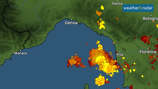
Severe thunderstorms developed around Genoa, Italy in recent days, with lightning strikes reaching the ground even away from the thunderclouds, an event known as positive ground flashes.

Positive ground flashes are relatively rare: only around 5 to 10% of all ground flashes are of this type. They usually originate high up in the thundercloud and can travel an astonishingly long distance from there.

For example, a bolt of lightning can strike many kilometres away from the actual thunderstorm – even in dry conditions. The images from the Gulf of Liguria near Genoa illustrate this impressively.

LightningRadar showing lightning strikes in the Gulf of Liguria.

This means that there may still be a risk of lightning, even if the storm clouds seem a distance away and there's no rain falling in the area. The LightningRadar shows at a glance recent strikes so you can stay alert to lighting around you.

Positive ground flashes are also dangerous because they can reach particularly high current levels. As a result, they are often significantly more powerful than ordinary negative ground flashes. They occur mainly during severe thunderstorms.

Weather & Radar editorial team
More on the topic
Record warmth in the Mediterranean. High water temperatures. . . Tuesday, 18 August 2026
Split graphic showing a hot southern Europe temperature map beside a sunny Mediterranean beach, with a sea-temperature icon highlighting very warm coastal waters.
Tuesday, 18 August 2026

High water temperatures

Record warmth in the Mediterranean
Late-summer views as shooting stars fly. Your weather - Your shots. . . Sunday, 23 August 2026
Split image showing a meteor streaking through a star-filled night sky on the left and wispy white cirrus clouds sweeping across a vivid blue daytime sky on the right.
Sunday, 23 August 2026

Your weather - Your shots

Late-summer views as shooting stars fly
Chance of thundery showers breaking out. Over the coming days. . . Tuesday, 18 August 2026
Split weather graphic showing a yellow thunderstorm warning across eastern England alongside radar with heavy showers and lightning near Sheffield, Leicester and East Anglia.
Tuesday, 18 August 2026

Over the coming days

Chance of thundery showers breaking out
All weather news
This might also interest you
Bright and warm conditions take hold. Spring-like outlook. . . Thursday, 23 April 2026
Split UK map showing warm temperatures up to 21 degrees in orange on the left and clear sunny conditions with temperatures from 12 to 18 degrees on the right, with sun icons across the country.
Thursday, 23 April 2026

Spring-like outlook

Bright and warm conditions take hold
A frozen start to the weekend. Icy conditions. . . Friday, 13 February 2026
UK temperature map dated 14.02 showing widespread subzero values in blue shading, with readings such as −4 in Glasgow, −3 in Dublin, and −2 in London, alongside a blue thermometer icon.
Friday, 13 February 2026

Icy conditions

A frozen start to the weekend
Storm Chandra makes impact. Severe gales & heavy rain. . . Tuesday, 27 January 2026
Split image showing strong winds over the UK on a forecast map and widespread rain and snow on a weather radar map.
Tuesday, 27 January 2026

Severe gales & heavy rain

Storm Chandra makes impact
All articles
Weather & Radar

Weather & Radar is also available on

Google Play StoreApp Store

Company

Contact us Privacy Policy Legal info Accessibility statement

Services

Uploader

Socials

facebooktwittertikToklinkList