Home
Weather London
WeatherRadar
RainfallRadar
TemperatureRadar
WindRadar
LightningRadar
Weather News
Editor's Pick
Discover the app
Weather widget
Contact us
Apps
Career
    Home / Editor's Pick /

    Highs over 30 degrees - Unusually warm for the long weekend

09:00
22 May 2026

Highs over 30 degrees
Unusually warm for the long weekend

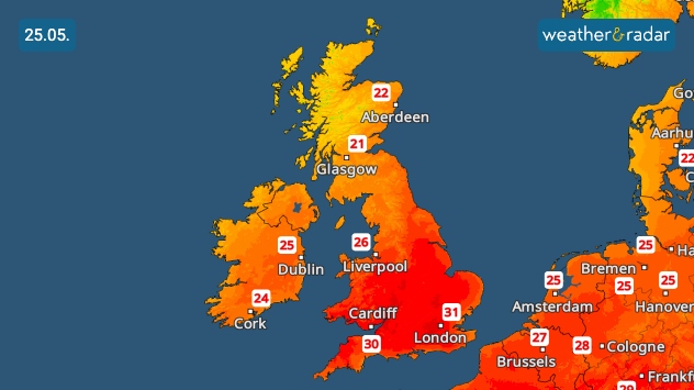
Temperature map of the UK and western Europe on 25.05 showing intense red and orange heat across southern Britain, with temperatures reaching 31°C near London and around 30°C in southwest England.
The first heatwave of the year takes hold over the weekend.

May's all-time heat record could be threatened during a sweltering bank holiday weekend where heat is concentrated in south-east England.

Currently sitting at 32.8 °C, the record high has been recorded twice. In Camden Square back in 1922 during a heatwave which resulted in daily date records from May 20th to May 24th, all at the same location, and again in 1944 in parts of south-east England.

Extraordinary amber heat-health warnings have been issued across the English Midlands, East Anglia, London, and South East. These warnings are typically issued by the Met Office and UK Health Service Agency from June to September. Yellow warnings cover all other regions of England.

Temperatures are widely approaching 30 °C up into the Midlands. The warmth doesn't quite reach Scotland where showers and cloud cover keep Monday's temperatures lower.

The warmest areas onto Monday are found in south-east England, with highs around 31 °C and the official heatwave threshold being met.

Keep that sunscreen handy, and seek shade when enjoying the early summer! Stay on top of everything with the TemperatureRadar.

Omega block sits over EuropeWhat's the cause?
Ryan Hathaway
More on the topic
Long-term trends need a pinch of salt. Heading over 40°C?. . . Tuesday, 21 July 2026
Temperature radar of 2022 heatwave where the all-time temperature record in the UK was set. Warning symbol overlain.
Tuesday, 21 July 2026

Heading over 40°C?

Long-term trends need a pinch of salt
New heatwave in southern Europe. Up to 45 degrees in Spain. . . Tuesday, 21 July 2026
Split temperature map showing extreme heat across Spain on the left and Greece on the right, with temperatures reaching 44°C near Murcia, around 40°C in parts of Greece, and a large thermometer icon highlighting dangerous heat.
Tuesday, 21 July 2026

Up to 45 degrees in Spain

New heatwave in southern Europe
Drought across large parts of Europe. High fire risk. . . Monday, 20 July 2026
Split image showing a Europe rainfall anomaly map on the left with widespread dry conditions across much of the continent, and a cracked, parched field on the right alongside a wildfire warning symbol highlighting elevated fire risk.
Monday, 20 July 2026

High fire risk

Drought across large parts of Europe
All weather news
This might also interest you
Super Typhoon Bavi threatens Taiwan. Up to 1,000 mm of rain. . . Wednesday, 8 July 2026
The image shows an intense tropical cyclone over the western Pacific, east of Taiwan and the Philippines. The centre of the system is depicted as a light purple and white vortex with a clearly visible eye, surrounded by a ring of red and orange areas indicating the strongest wind speeds. A white arrow marks the typhoon’s predicted track towards the north-west, in the direction of Taiwan. To the west of the storm lie the Philippines, with the cities of Manila and Cebu; to the north of these lies Taiwan, with Taipei. Further west, the Chinese coast, including Hong Kong, and parts of Vietnam can be seen. The coloured wind map shows predominantly green areas outside the storm’s core, indicating significantly weaker winds. White streamlines illustrate the typhoon’s anti-clockwise circulation in the Northern Hemisphere. The highest wind speeds are concentrated around the eye of the cyclone.
Wednesday, 8 July 2026

Up to 1,000 mm of rain

Super Typhoon Bavi threatens Taiwan
A frozen start to the weekend. Icy conditions. . . Friday, 13 February 2026
UK temperature map dated 14.02 showing widespread subzero values in blue shading, with readings such as −4 in Glasgow, −3 in Dublin, and −2 in London, alongside a blue thermometer icon.
Friday, 13 February 2026

Icy conditions

A frozen start to the weekend
Historic Storm Éowyn arrives. On this day.... . . Saturday, 24 January 2026
Split image showing a person in a yellow jacket struggling against strong winds and heavy rain on a street at night on the left, and an Irish wind forecast map on the right with red and purple shading, gusts up to 75 mph, and a wind warning icon, divided by a curved white line.
Saturday, 24 January 2026

On this day...

Historic Storm Éowyn arrives
All articles
Weather & Radar

Weather & Radar is also available on

Google Play StoreApp Store

Company

Contact us Privacy Policy Legal info Accessibility statement

Services

Uploader

Socials

facebooktwittertikToklinkList