Home
Weather London
WeatherRadar
RainfallRadar
TemperatureRadar
WindRadar
LightningRadar
Weather News
Editor's Pick
Discover the app
Weather widget
Contact us
Apps
Career
    Home /

    Frontal influence remains - More changeable through the week

13:11
21 September 2026

Frontal influence remains
More changeable through the week

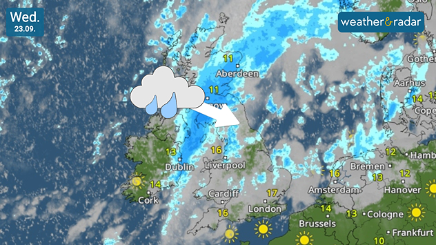
Weather map for Wednesday 29.09 showing a broad rain band crossing Scotland, Ireland, and northern England, with an arrow indicating southeastern movement.
Wednesday brings a change with the latest frontal rain band moving through.

Another changeable week on the cards with warm temperatures but Atlantic fronts maintain their influence from mid-week bringing more rain and growing winds.

The week starts under the influence of high pressure. Initially over the English Channel on Monday before spreading across western and central Europe as a weak cold front moves east across Ireland and Scotland bringing thick cloud cover and showers.

By Wednesday, more widespread rain moves through Northern Ireland and Scotland early in the day thanks to the latest front. This moves south-east reaching the south-east of England where much of Wednesday is bright and warm before showers develop in the afternoon.

Drier, brighter weather follows in the wake of the front. Conditions turn dry and more settled on Thursday for many, though another frontal system with rain and strengthening winds arrives in the far west and north-west later in the day.

Resulting in winder and changeable conditons for many on Friday and Saturday amid a large low-pressure system near Iceland.

High pressure over the near continent may keep things more settled further south and east, as temperatures remain mild, though not quite reaching the heatwave threshold that some reports had suggested.

Keep an eye on how the fronts will affect your days on the WeatherRadar.

London

Mo
11
22
Tu
13
25
We
16
24
Th
12
21
Fr
13
22
Sa
15
21
Su
14
22
Mo
14
22
Tu
14
23
We
15
23
Th
15
24
Fr
16
24
Sa
16
24
Su
16
24
Max (°C)
Min (°C)
moreless

Manchester

Mo
11
18
Tu
15
19
We
16
17
Th
8
18
Fr
14
16
Sa
10
18
Su
12
20
Mo
11
18
Tu
12
20
We
13
20
Th
13
20
Fr
14
21
Sa
13
20
Su
14
18
Max (°C)
Min (°C)
moreless

Dublin

Mo
13
22
Tu
16
21
We
13
17
Th
9
19
Fr
14
17
Sa
11
19
Su
10
16
Mo
10
17
Tu
13
17
We
12
18
Th
12
18
Fr
12
19
Sa
11
17
Su
10
15
Max (°C)
Min (°C)
moreless

Edinburgh

Mo
10
20
Tu
15
20
We
12
17
Th
6
16
Fr
12
16
Sa
12
18
Su
11
17
Mo
11
16
Tu
14
19
We
13
18
Th
13
19
Fr
13
19
Sa
11
17
Su
11
15
Max (°C)
Min (°C)
moreless

Cardiff

Mo
10
21
Tu
14
19
We
15
21
Th
8
20
Fr
14
18
Sa
10
19
Su
14
19
Mo
12
19
Tu
14
21
We
14
21
Th
14
21
Fr
15
21
Sa
15
20
Su
14
19
Max (°C)
Min (°C)
moreless

Weather & Radar editorial team
More on the topic
Hurricane threat off the coast of Mexico. Storm and rain. . . Monday, 21 September 2026
Split image showing a powerful tropical system southwest of Acapulco on a wind map and palm trees bending sharply in strong winds.
Monday, 21 September 2026

Storm and rain

Hurricane threat off the coast of Mexico
A snowy winter in the Andes. Avalanches and storms. . . Tuesday, 15 September 2026
Tuesday, 15 September 2026

Avalanches and storms

A snowy winter in the Andes
Low delivers days of gusty conditions. Into the weekend. . . Thursday, 17 September 2026
Wind map showing low pressure near the Faroe Islands, with winds reaching 35 mph around Aberdeen and Dublin and stronger Atlantic winds west of the UK.
Thursday, 17 September 2026

Into the weekend

Low delivers days of gusty conditions
All weather news
This might also interest you
Cheshire Gap produces shower funnel. Local phenomenon. . . Wednesday, 9 September 2026
Weather map showing showers moving southeast from Liverpool toward Birmingham, driven by Cheshire Gap convergence across central England.
Wednesday, 9 September 2026

Local phenomenon

Cheshire Gap produces shower funnel
A marked change in the weather. Cold front heading south. . . Monday, 7 September 2026
Map of Europe showing a cold front stretching from Scandinavia to Spain. Thunderstorms are shown in southern and central Europe.
Monday, 7 September 2026

Cold front heading south

A marked change in the weather
Hottest summer on record for Ireland. Beating 2025's record. . . Thursday, 3 September 2026
Temperature map of Ireland showing 29°C in Dublin, 26°C in Cork, 24°C in Belfast, and 23°C in Galway, with a red thermometer icon.
Thursday, 3 September 2026

Beating 2025's record

Hottest summer on record for Ireland
All articles
Weather & Radar

Weather & Radar is also available on

Google Play StoreApp Store

Company

Contact us Privacy Policy Legal info Accessibility statement

Services

Uploader

Socials

facebooktwittertikToklinkList