Home
Weather London
WeatherRadar
RainfallRadar
TemperatureRadar
WindRadar
LightningRadar
Weather News
Editor's Pick
Discover the app
Weather widget
Contact us
Apps
Career
    Home /

    Weekend outlook - More unsettled than the week behind

16:39
29 May 2026

Weekend outlook
More unsettled than the week behind

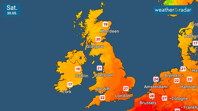
Cooler, but still above-average temperatures for the time of year on Saturday.

The outlook is much more unsettled than we've seen of late, with the heatwave breaking and more widespread rain falling.

On Saturday, it remains relatively cool in Ireland and Scotland with unsettled and often showery weather. Drier with sunny spells further north and east.

Temperatures will again reach around 25 °C and above, highs of around 28 °C expected in the Home Counties.

Into Sunday and it is changeable, and generally cooler, as Atlantic systems become more dominant. Regular and sometimes heavy showers fall in Ireland, into the north and west of the UK.

Away from this, to the east and south, temperatures are remaining above average for the time of year, again at their highest to the south-east of England.

Meanwhile, the north-west is cooler than average, feeling even chillier with that frequent rainfall as we head into June.

London

Th
19
25
Fr
15
27
Sa
15
22
Su
13
20
Mo
15
18
Tu
13
18
We
12
20
Th
12
20
Fr
14
22
Sa
14
22
Su
13
21
Mo
14
22
Tu
13
22
We
14
24
Max (°C)
Min (°C)
moreless

Manchester

Th
13
21
Fr
11
22
Sa
13
18
Su
13
18
Mo
14
16
Tu
13
16
We
11
19
Th
10
17
Fr
12
18
Sa
11
19
Su
11
19
Mo
12
20
Tu
12
20
We
12
20
Max (°C)
Min (°C)
moreless

Dublin

Th
14
22
Fr
12
18
Sa
13
20
Su
14
20
Mo
14
16
Tu
11
17
We
9
17
Th
10
16
Fr
10
17
Sa
9
17
Su
9
17
Mo
10
18
Tu
10
19
We
9
18
Max (°C)
Min (°C)
moreless

Cardiff

Th
14
22
Fr
9
21
Sa
14
19
Su
14
18
Mo
14
17
Tu
12
16
We
12
17
Th
11
17
Fr
13
18
Sa
12
17
Su
12
17
Mo
13
19
Tu
12
19
We
12
20
Max (°C)
Min (°C)
moreless

Edinburgh

Th
14
18
Fr
10
19
Sa
12
18
Su
9
16
Mo
12
18
Tu
12
16
We
10
16
Th
11
17
Fr
12
18
Sa
10
18
Su
10
17
Mo
11
19
Tu
9
18
We
11
17
Max (°C)
Min (°C)
moreless
Weather & Radar editorial team
More on the topic
Nighttime marina with sailboats and glowing harbor lights beneath electric-blue noctilucent clouds stretching across the dark twilight sky.
Saturday, 23 May 2026

A silvery haze in the sky

The season of the luminous night clouds
Split image showing a nighttime lightning strike beneath storm clouds on the left and a lightning detection map with dense storm activity across central England on the right.
Wednesday, 27 May 2026

Trickier than you think

Why it's hard to pinpoint thunderstorms
A composite image showing the Temperature Radar and a drinking fountain. The Temperature Radar shows Thursday’s maximum temperatures of up to 37.8 degrees in France, whilst people use a fountain to cool off.
Friday, 29 May 2026

Up to 38 °C in France

Heatwave clocks more record temperatures
All weather news
This might also interest you
Weather map of the USA showing an active thunderstorm front between Kansas City and Minneapolis. Numerous lightning symbols indicate severe thunderstorms, along with a severe weather warning symbol.
Monday, 18 May 2026

Tornadoes possible

Dangerous thunderstorm front over the US
The map shows current water temperatures in Europe and the Mediterranean. The water is particularly warm off the coast of Spain and North Africa, and cooler in the North Sea and the Baltic Sea.
Wednesday, 20 May 2026

Ideal for half-term

Warming waters in holiday spots
Split weather graphic showing radar-detected rain and lightning across northern England on the left and a yellow thunderstorm warning area over eastern England on the right, with a central warning symbol.
Tuesday, 19 May 2026

Hail possible too

Continued thunderstorm risk
All articles
Weather & Radar

Weather & Radar is also available on

Google Play StoreApp Store

Company

Contact us Privacy Policy Legal info Accessibility statement

Services

Uploader

Socials

facebooktwittertikToklinkList