Home
Weather London
WeatherRadar
RainfallRadar
TemperatureRadar
WindRadar
LightningRadar
Weather News
Editor's Pick
Discover the app
Weather widget
Contact us
Apps
Career
    Home / Editor's Pick /

    The season of the luminous night clouds - A silvery haze in the sky

10:00
23 May 2026

A silvery haze in the sky
The season of the luminous night clouds

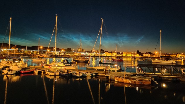
Noctilucent clouds often appear during the late twilight. Captured here in Dungarvan, Co. Waterford. - © Weather & Radar Uploader

The season for noctilucent clouds is upon us once again. Around 1.5 hours after sunset, their silvery veils appear low on the northern horizon. They are a real sight to behold on short summer nights.

These clouds are made up of tiny ice crystals and form high above the usual weather clouds, at an altitude of around 80 km.

Up there, temperatures can drop below minus 100 degrees. They resemble fine waves and ribbed structures.

Because the sun remains just below the horizon at night, the clouds continue to shimmer even when it has long since grown dark on the ground. Strong high-altitude winds constantly distort and reshape the silvery veils.

However, noctilucent clouds do not appear every night and as with any high-altitude event, clear skies are needed for this celestial spectacle.

Tommy Kühnlein
More on the topic
Lee waves flow over the UK and Ireland. On the WeatherRadar. . . Monday, 6 July 2026
Satellite weather map of the UK and Ireland showing parallel bands of low cloud highlighted over southern Scotland and northern England, with additional cloud streets over Wales and western England circled in white.
Monday, 6 July 2026

On the WeatherRadar

Lee waves flow over the UK and Ireland
Forest fires rage in southern Europe. Drought and wind. . . Monday, 6 July 2026
Split screen. On the left, a weather map of France and Spain showing the plumes of smoke from the forest fires. On the right, a fire-fighting aircraft in action.
Monday, 6 July 2026

Drought and wind

Forest fires rage in southern Europe
Yet another typhoon in the Pacific. Gusts of over 185 mph. . . Friday, 3 July 2026
Wind forecast map of the western Pacific showing a powerful typhoon east of Guam with a well-defined eye, strong wind circulation, and a windsock warning icon.
Friday, 3 July 2026

Gusts of over 185 mph

Yet another typhoon in the Pacific
All weather news
This might also interest you
Storm Chandra makes impact. Severe gales & heavy rain. . . Tuesday, 27 January 2026
Split image showing strong winds over the UK on a forecast map and widespread rain and snow on a weather radar map.
Tuesday, 27 January 2026

Severe gales & heavy rain

Storm Chandra makes impact
A frozen start to the weekend. Icy conditions. . . Friday, 13 February 2026
UK temperature map dated 14.02 showing widespread subzero values in blue shading, with readings such as −4 in Glasgow, −3 in Dublin, and −2 in London, alongside a blue thermometer icon.
Friday, 13 February 2026

Icy conditions

A frozen start to the weekend
Bright and warm conditions take hold. Spring-like outlook. . . Thursday, 23 April 2026
Split UK map showing warm temperatures up to 21 degrees in orange on the left and clear sunny conditions with temperatures from 12 to 18 degrees on the right, with sun icons across the country.
Thursday, 23 April 2026

Spring-like outlook

Bright and warm conditions take hold
All articles
Weather & Radar

Weather & Radar is also available on

Google Play StoreApp Store

Company

Contact us Privacy Policy Legal info Accessibility statement

Services

Uploader

Socials

facebooktwittertikToklinkList