Home
Weather London
WeatherRadar
RainfallRadar
TemperatureRadar
WindRadar
LightningRadar
Weather News
Editor's Pick
Discover the app
Weather widget
Contact us
Apps
Career
    Home / Editor's Pick /

    Extreme heat in the Mediterranean: Hot air spreads

07:00
7 August 2025

Holiday hot spots
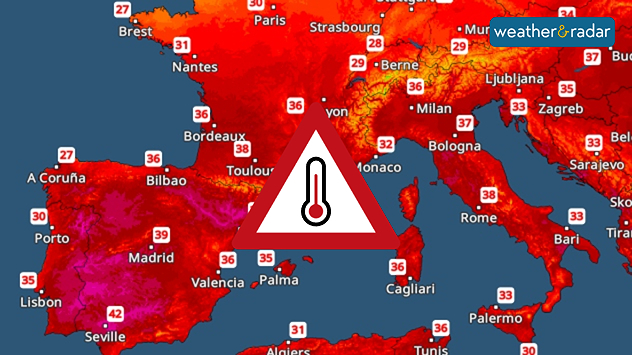
Intense heat in the Mediterranean

Temperature map showing very hot temperatures across the Mediterranean.
The Temperature Radar forecast for Sunday.

In Southern Europe, popular holiday hotspots are experiencing an intense blast of heat, with no end in sight.

Spain is currently experiencing particularly high temperatures. In Madrid, temperatures are expected to reach 40 degrees today. The country is set to heat up even further over the coming days.

The heat also continues to spread across southern France and into Italy over the coming days. On Sunday, peak temperatures of 40 degrees and above are expected in Montpellier. Temperatures in Rome will also rise above 35 degrees.

Forecast for selected cities:

Seville

Tu
19
39
We
21
39
Th
23
40
Fr
23
38
Sa
22
34
Su
20
34
Mo
22
32
Tu
22
35
We
22
34
Th
20
32
Fr
21
33
Sa
21
35
Su
21
35
Mo
21
35
Max (°C)
Min (°C)
moreless

Montpellier

Tu
24
35
We
21
34
Th
21
35
Fr
22
34
Sa
23
33
Su
24
33
Mo
23
31
Tu
22
30
We
22
32
Th
23
31
Fr
23
32
Sa
22
31
Su
22
30
Mo
20
30
Max (°C)
Min (°C)
moreless

Rome

Tu
24
39
We
25
36
Th
24
37
Fr
24
35
Sa
23
35
Su
24
34
Mo
23
33
Tu
23
33
We
22
32
Th
22
34
Fr
22
34
Sa
22
33
Su
22
33
Mo
22
33
Max (°C)
Min (°C)
moreless

The nights will not bring any relief either. Minimum temperatures will generally range between 20 and 25 degrees. The temperature curve will only start to dip next week.

Sebastian Keßler
Ryan Hathaway
More on the topic
The Perseids reach their peak. Shooting stars overhead. . . Tuesday, 11 August 2026
Shooting stars in the night sky
Tuesday, 11 August 2026

Shooting stars overhead

The Perseids reach their peak
Europe's summer set to to break records. Extreme heat and drought. . . Tuesday, 11 August 2026
Split image showing a European heat map with temperatures reaching 39°C in France and Spain on the left, and a severely depleted river with exposed sandy banks beneath a bridge on the right.
Tuesday, 11 August 2026

Extreme heat and drought

Europe's summer set to to break records
Poor harvest expected after drought. Rain remains scarce. . . Thursday, 6 August 2026
Split image showing an aerial view of drought-stricken parkland with dry yellow-brown grass surrounding a church on the left, and a temperature map of England and Wales on the right with temperatures reaching 30°C in southeast England.
Thursday, 6 August 2026

Rain remains scarce

Poor harvest expected after drought
All weather news
This might also interest you
Flooding, gales, and heavy snow. Storm Chandra. . . Tuesday, 27 January 2026
Split image showing aerial flooding in a town with muddy water covering roads on the left, and a rural road on the right blocked by heavy snowfall with vans stopped and a person walking in snow.
Tuesday, 27 January 2026

Storm Chandra

Flooding, gales, and heavy snow
Super Typhoon Bavi threatens Taiwan. Up to 1,000 mm of rain. . . Wednesday, 8 July 2026
The image shows an intense tropical cyclone over the western Pacific, east of Taiwan and the Philippines. The centre of the system is depicted as a light purple and white vortex with a clearly visible eye, surrounded by a ring of red and orange areas indicating the strongest wind speeds. A white arrow marks the typhoon’s predicted track towards the north-west, in the direction of Taiwan. To the west of the storm lie the Philippines, with the cities of Manila and Cebu; to the north of these lies Taiwan, with Taipei. Further west, the Chinese coast, including Hong Kong, and parts of Vietnam can be seen. The coloured wind map shows predominantly green areas outside the storm’s core, indicating significantly weaker winds. White streamlines illustrate the typhoon’s anti-clockwise circulation in the Northern Hemisphere. The highest wind speeds are concentrated around the eye of the cyclone.
Wednesday, 8 July 2026

Up to 1,000 mm of rain

Super Typhoon Bavi threatens Taiwan
Historic Storm Éowyn arrives. On this day.... . . Saturday, 24 January 2026
Split image showing a person in a yellow jacket struggling against strong winds and heavy rain on a street at night on the left, and an Irish wind forecast map on the right with red and purple shading, gusts up to 75 mph, and a wind warning icon, divided by a curved white line.
Saturday, 24 January 2026

On this day...

Historic Storm Éowyn arrives
All articles
Weather & Radar

Weather & Radar is also available on

Google Play StoreApp Store

Company

Contact us Privacy Policy Legal info Accessibility statement

Services

Uploader

Socials

facebooktwittertikToklinkList