Home
Weather London
WeatherRadar
RainfallRadar
TemperatureRadar
WindRadar
LightningRadar
Weather News
Editor's Pick
Discover the app
Weather widget
Contact us
Apps
Career
    Home /

    Cold and frosty with snow in the north

17:31
9 November 2026

An early taste of winter
Cold and frosty with snow in the north

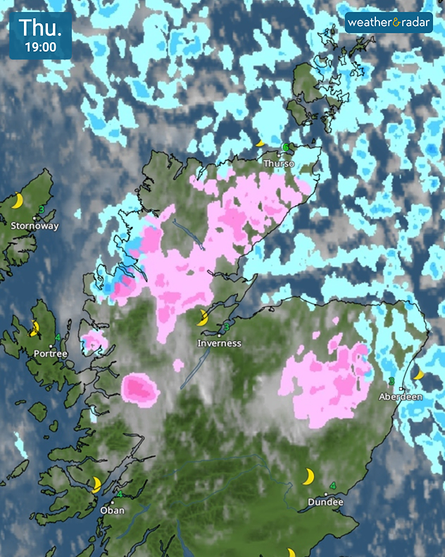
Weather map for Thursday 19:00 showing pink snow areas across the Scottish Highlands near Inverness and Aberdeen, with blue rain showers and temperatures of 3–6°C.
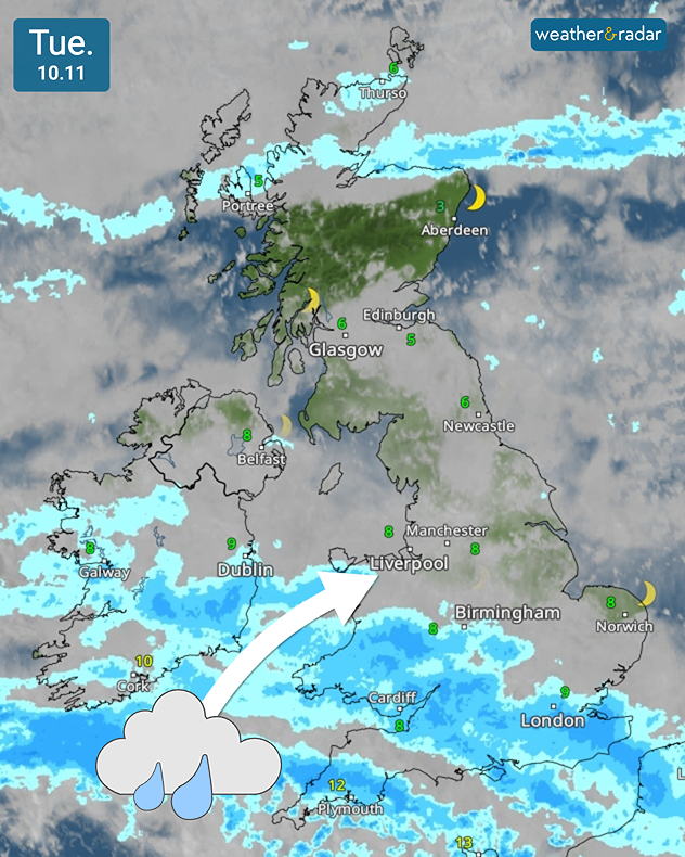
Weather map for Tuesday 10.11 showing blue rain bands across southern Britain and Ireland, with an arrow pointing northeast and temperatures of 3–12°C.
1/2
Snow showers spread across the higher ground of Scotland.

It's an unsettled week ahead with the days growing colder, and a more widespread dusting of snow in parts of Scotland.

Tuesday begins with fog, dense in places, spreading once again across parts of the Midlands and East Anglia. Visibility may drop to around 100 metres for some, extra care will be needed for the morning commute.

Further fog disruption expectedread more

Later on, rain pushes into south-west England as a front associated with low pressure north-west of Portugal becomes more influential to out weather.

Towards the evening, this spreads further into central Ireland, Wales, and the English Midlands but dry elsewhere with some sun for Scotland and northern England.

From midweek, high pressure begins to build between Greenland and Iceland. Fronts remain dominant with rain in southern England but generally dry and fine elsewhere. By Wednesday evening showers may turn wintry with snow over higher ground in northern to north-west Scotland.

By the end of the week, a colder northwesterly airflow brings drier, brighter weather. Though still more unsettled in the far north and north-east of the UK with snow falling at altitude. Morning frost will be become more prevalent with an early taste of winter.

Temperatures could fall as low as -5°C overnight in more rural spots as the week ends on a chilly note.

London

Mo
5
10
Tu
6
10
We
9
10
Th
6
9
Fr
3
8
Sa
0
9
Su
2
9
Mo
4
10
Tu
7
10
We
4
10
Th
7
9
Fr
8
10
Sa
5
9
Su
4
9
Max (°C)
Min (°C)
moreless

Manchester

Mo
4
9
Tu
5
9
We
6
9
Th
2
6
Fr
-1
7
Sa
1
6
Su
1
7
Mo
5
10
Tu
6
8
We
4
9
Th
6
9
Fr
6
8
Sa
3
6
Su
2
7
Max (°C)
Min (°C)
moreless

Dublin

Mo
3
13
Tu
8
10
We
9
10
Th
3
8
Fr
0
8
Sa
1
10
Su
5
10
Mo
9
11
Tu
5
9
We
5
11
Th
8
10
Fr
6
9
Sa
3
9
Su
5
10
Max (°C)
Min (°C)
moreless

Edinburgh

Mo
5
9
Tu
3
7
We
2
7
Th
1
8
Fr
1
7
Sa
3
8
Su
4
8
Mo
6
8
Tu
4
7
We
4
9
Th
5
8
Fr
3
7
Sa
1
7
Su
0
6
Max (°C)
Min (°C)
moreless

Cardiff

Mo
5
7
Tu
7
8
We
7
9
Th
4
8
Fr
0
9
Sa
-1
8
Su
2
9
Mo
7
12
Tu
7
9
We
4
10
Th
7
11
Fr
6
10
Sa
3
9
Su
3
9
Max (°C)
Min (°C)
moreless
Weather & Radar editorial team

More on the topic

Foggy mornings and crisp autumn days. Your weather - Your shots. . . Sunday, 8 November 2026
Sunday, 8 November 2026

Your weather - Your shots

Foggy mornings and crisp autumn days
Brisk easterly winds chill the Channel. Feels like temperature. . . Wednesday, 4 November 2026
Wind map showing 35 mph winds near London, Plymouth and Cherbourg, with a windsock symbol and white arrow pointing west along the English Channel.
Wednesday, 4 November 2026

Feels like temperature

Brisk easterly winds chill the Channel
Blocking high brings anticyclonic gloom. Overcast days. . . Tuesday, 3 November 2026
Split weather maps showing widespread cloud across the UK and Ireland alongside a high-pressure system centred over Britain, with isobars near 1035 hPa.
Tuesday, 3 November 2026

Overcast days

Blocking high brings anticyclonic gloom
All weather news

This might also interest you

Severe weather risk at holiday spots. Across the Mediterranean. . . Friday, 30 October 2026
Weather Radar shows a risk of flooding in Greece and Turkey. Meanwhile, the Wind Radar shows a storm system off Sicily with gusts of up to 50 miles per hour.
Friday, 30 October 2026

Across the Mediterranean

Severe weather risk at holiday spots
Wettest week in England for two years. Stormy assistance. . . Thursday, 29 October 2026
Weather map for Saturday 24.10 showing a swirling Atlantic low, Storm Boelo, west of Scotland and widespread blue rain bands across the UK, Ireland and northern France.
Thursday, 29 October 2026

Stormy assistance

Wettest week in England for two years
From late summer to storm warnings. Contrasts in Europe. . . Thursday, 29 October 2026
Split image: On the left, the temperature radar for Spain and Portugal shows readings of up to 28 degrees. On the right, waves crash onto a flooded beach dotted with parasols and sun loungers amid stormy weather.
Thursday, 29 October 2026

Contrasts in Europe

From late summer to storm warnings
All articles
Weather & Radar

Weather & Radar is also available on

Google Play StoreApp Store

Company

Contact us Privacy Policy Legal info Accessibility statement

Services

Uploader

Socials

facebooktwittertikToklinkList