Home
Weather London
WeatherRadar
RainfallRadar
TemperatureRadar
WindRadar
LightningRadar
Weather News
Editor's Pick
Discover the app
Weather widget
Contact us
Apps
Career
    Home / Editor's Pick /

    Below -10 °C in areas - Coldest night of winter so far

09:00
6 January 2026

Below -10 °C in areas
Coldest night of winter so far

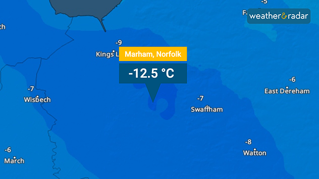
Temperature map of eastern England highlighting Marham, Norfolk at −12.5 °C, with surrounding areas shaded in deep blue and nearby locations labelled with subzero values.
An icy night in Norfolk where the lowest temperature of the year was felt in Marham.

A low of -12.5 °C in a Norfolk village overnight is the coldest temperature recorded this season so far.

The village of Marham saw the current seasonal record, with an Arctic chill also dropping temperatures to below -10 °C in the Scotland's Dalwhinnie (-11.2 °C) and Tulloch Bridge (-10.7 °C).

This chill was accompanied by heavy snow in places, resulting in school closures across parts of Scotland and Northern Ireland.

A temporary reprieve from the snow begins on Wednesday before stormy conditions take control later in the week.

Low-pressure brings stronger winds to southern areas of the UK and a return of rain and snow.

Storm front brings turbulent weatherread more
Ryan Hathaway
More on the topic
Heat becoming a bigger factor in drought. New study. . . Thursday, 23 July 2026
A hand holds dry, dusty earth above a parched field. The ground is cracked and covered with plant debris – a sign of prolonged drought.
Thursday, 23 July 2026

New study

Heat becoming a bigger factor in drought
Heavier rainfall over the week for some. Ireland & Scotland. . . Tuesday, 28 July 2026
Split image showing a Europe rainfall accumulation forecast map on the left with the highest totals across the UK, Ireland, and Scandinavia, and a satellite weather map on the right with a broad band of rain stretching across Ireland, Scotland, and northern Britain, highlighted by a rain cloud icon.
Tuesday, 28 July 2026

Ireland & Scotland

Heavier rainfall over the week for some
Catastrophic forest fires in Europe. Thousands evacuated. . . Monday, 27 July 2026
A composite image showing a temperature map of south-western Europe and a drone shot of a forest fire near Cap Ferret. A warning symbol featuring a flame indicates the increased risk of forest fires.
Monday, 27 July 2026

Thousands evacuated

Catastrophic forest fires in Europe
All weather news
This might also interest you
Seasonal warmth between spring thunder. Your weather - Your shots. . . Sunday, 19 April 2026
Split image showing coastal sunset with layered lenticular clouds over rooftops and palm trees on the left, and a green valley with river and hills under soft daylight on the right.
Sunday, 19 April 2026

Your weather - Your shots

Seasonal warmth between spring thunder
Historic Storm Éowyn arrives. On this day.... . . Saturday, 24 January 2026
Split image showing a person in a yellow jacket struggling against strong winds and heavy rain on a street at night on the left, and an Irish wind forecast map on the right with red and purple shading, gusts up to 75 mph, and a wind warning icon, divided by a curved white line.
Saturday, 24 January 2026

On this day...

Historic Storm Éowyn arrives
Flooding, gales, and heavy snow. Storm Chandra. . . Tuesday, 27 January 2026
Split image showing aerial flooding in a town with muddy water covering roads on the left, and a rural road on the right blocked by heavy snowfall with vans stopped and a person walking in snow.
Tuesday, 27 January 2026

Storm Chandra

Flooding, gales, and heavy snow
All articles
Weather & Radar

Weather & Radar is also available on

Google Play StoreApp Store

Company

Contact us Privacy Policy Legal info Accessibility statement

Services

Uploader

Socials

facebooktwittertikToklinkList