Home
Weather London
WeatherRadar
RainfallRadar
TemperatureRadar
WindRadar
LightningRadar
Weather News
Editor's Pick
Discover the app
Weather widget
Contact us
Apps
Career
    Home /

    Bank holiday outlook - Gusty with continued risk of thunder

11:17
28 August 2026

Bank holiday outlook
Gusty with continued risk of thunder

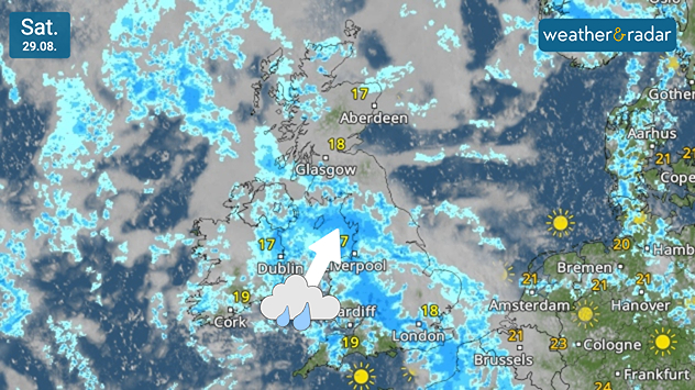
Weather map for Saturday 29.08 showing widespread rain across the UK and Ireland, with an arrow indicating rain moving north and temperatures of 17–19°C.
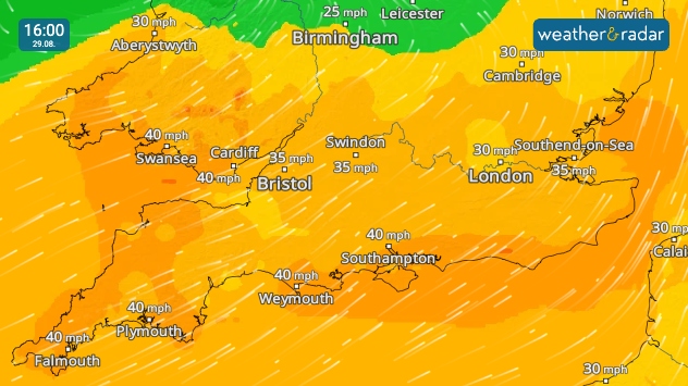
Wind forecast for 16:00 on 29.08 showing gusts of 35–40 mph across southern England and Wales, including Swansea, Bristol, Southampton, Plymouth and Weymouth.
1/2
More heavy rain pushes through on Saturday.

The long weekend brings more unsettled weather across parts of the UK, with a chance of some final thundery showers still possible.

Saturday sees heavy rain at times pushing east across Ireland into Wales and England through the day. Clearing from western Ireland by the afternoon with sunnier conditions following for southern England, though a chance of thundery showers remain.

Daily highs rest around 20°C in the south of Ireland and south-east of England, hovering around the upper-teens elsewhere with some stronger winds developing by the afternoon across southern Wales and England. Gusts around 40 mph possible across coastal areas.

Sunday brings another mix of showers and sunny spells. At times, the showers may turn heavy and thundery once again across England and southern Scotland.

Two low-pressure systems bring swirling winds with stronger gusts in western to south-western regions through Sunday. By bank holiday Monday, the latest band of rain continues pushing east through the morning, bringing drier, sunnier conditions as it passes.

Whether you have a trip planned for the last summer long weekend, or have a relaxed few days indoors, keep an eye on the WeatherRadar for the latest look at conditions.

London

Fr
16
23
Sa
18
20
Su
18
23
Mo
16
20
Tu
14
20
We
13
21
Th
18
25
Fr
18
26
Sa
17
25
Su
15
23
Mo
17
25
Tu
15
23
We
16
24
Th
15
23
Max (°C)
Min (°C)
moreless

Manchester

Fr
16
20
Sa
15
18
Su
15
20
Mo
13
16
Tu
13
17
We
11
17
Th
15
20
Fr
15
21
Sa
13
19
Su
12
19
Mo
14
20
Tu
13
18
We
13
18
Th
12
18
Max (°C)
Min (°C)
moreless

Dublin

Fr
16
22
Sa
15
17
Su
14
18
Mo
12
19
Tu
11
18
We
8
18
Th
15
21
Fr
14
18
Sa
11
18
Su
11
19
Mo
14
21
Tu
11
18
We
13
19
Th
10
18
Max (°C)
Min (°C)
moreless

Edinburgh

Fr
15
19
Sa
15
18
Su
14
17
Mo
13
17
Tu
11
16
We
11
17
Th
13
19
Fr
13
19
Sa
11
18
Su
11
18
Mo
13
19
Tu
11
17
We
12
17
Th
11
17
Max (°C)
Min (°C)
moreless

Cardiff

Fr
15
20
Sa
17
19
Su
16
20
Mo
14
18
Tu
14
20
We
11
20
Th
17
23
Fr
17
22
Sa
15
21
Su
14
21
Mo
15
23
Tu
15
20
We
16
21
Th
14
21
Max (°C)
Min (°C)
moreless
Weather & Radar editorial team
More on the topic
Violent thunderstorms mark summer's end. Hail and gusts of wind. . . Thursday, 27 August 2026
Severe thunderstorm warning map showing a level 3 red zone from eastern France toward Belgium, surrounded by orange and yellow alerts extending into western Germany.
Thursday, 27 August 2026

Hail and gusts of wind

Violent thunderstorms mark summer's end
Slow moving rain brings flooding. More alerts live. . . Thursday, 27 August 2026
Weather radar at 11:00 on 27.08 showing widespread heavy rain from Liverpool through the Midlands to eastern England, with an arrow indicating rain moving north.
Thursday, 27 August 2026

More alerts live

Slow moving rain brings flooding
Europe's storm situation still volatile. Supercell danger. . . Friday, 28 August 2026
Split screen. On the left, a weather map of Europe showing thunderstorms, lightning and a warning symbol. On the right, a photograph of a severe thunderstorm
Friday, 28 August 2026

Supercell danger

Europe's storm situation still volatile
All weather news
This might also interest you
Severe weather risk in holiday spots. Hail and heavy rain. . . Wednesday, 19 August 2026
Split weather graphic showing intense thunderstorms and widespread lightning across northern Italy and Switzerland on the left, with severe warning zones from yellow to red around Milan and the southern Alps on the right.
Wednesday, 19 August 2026

Hail and heavy rain

Severe weather risk in holiday spots
Hottest day of the year so far. Close to August record. . . Thursday, 13 August 2026
Temperature map of London showing 38.1°C at Kew Gardens, with surrounding readings of 35–36°C and deep red shading indicating extreme heat.
Thursday, 13 August 2026

Close to August record

Hottest day of the year so far
Drought brings flash flood risks. As rain returns. . . Wednesday, 19 August 2026
Weather radar map of the UK and Ireland showing widespread showers, with a rain icon and flood warning symbol highlighting the risk from rainfall.
Wednesday, 19 August 2026

As rain returns

Drought brings flash flood risks
All articles
Weather & Radar

Weather & Radar is also available on

Google Play StoreApp Store

Company

Contact us Privacy Policy Legal info Accessibility statement

Services

Uploader

Socials

facebooktwittertikToklinkList