Home
Weather London
WeatherRadar
RainfallRadar
TemperatureRadar
WindRadar
LightningRadar
Weather News
Editor's Pick
Discover the app
Weather widget
Contact us
Apps
Career
    Home / Editor's Pick /

    Hottest day of the year so far and close to all-time August record

15:44
13 August 2026

Close to August record
Hottest day of the year so far

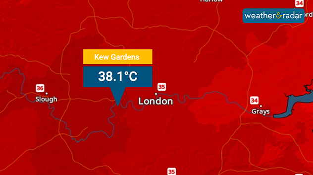
Temperature map of London showing 38.1°C at Kew Gardens, with surrounding readings of 35–36°C and deep red shading indicating extreme heat.
A high recorded at Kew Gardens marks the hottest temperature of 2026.

Thursday has become the hottest day of the year in the UK after temperatures passed 38 degrees in London.

With a reading of 38.1°C at Kew Gardens Thursday afternoon, the day fractionally replaces the previous high for the year from June when a high of 38°C was recorded in Lingwood, Norfolk.

There is still a slight chance that the all-time August record temperature could be broken too. This currently stands at 38.5°C from 2003.

If the August record does not fall, it is unlikely to be beaten soon with temperatures dropping into the weekend as the heatwave across parts of England eases.

In London, the daily high on Sunday will fall by over 10 degrees to around 25°C. It's cooler still in the Midlands, Nottingham is expected to see a high around 19°C on Sunday, falling from the mid-30s.

August record check

The existing August record temperature from 2003, recorded at Faversham, Kent is now recognised as being from a weather station later found to be unreliable. The second hottest day ever stands at 38.1°C, now matched, also at Kew Gardens where this year's high was recorded.

Ryan Hathaway
More on the topic
Summer of 2026: hottest on record. Breaking 2025 record. . . Tuesday, 1 September 2026
Aerial view of a large park with dry yellow-brown grass, intersecting footpaths, and a few people walking across the parched landscape beneath clear summer skies.
Tuesday, 1 September 2026

Breaking 2025 record

Summer of 2026: hottest on record
A generally gusty Thursday. Moderate but notable wind. . . Wednesday, 2 September 2026
Wind forecast showing widespread 25-30 mph winds across the UK and Ireland, including Glasgow, Dublin, Cork, Cardiff, and London, with a windsock symbol.
Wednesday, 2 September 2026

Moderate but notable wind

A generally gusty Thursday
Autumn arrives with vivid colour. Your weather - Your shots. . . Sunday, 6 September 2026
Split image showing peach-lit textured clouds above silhouetted trees and golden cumulus clouds reflected in a calm canal lined with boats.
Sunday, 6 September 2026

Your weather - Your shots

Autumn arrives with vivid colour
All weather news
This might also interest you
Long-term trends need a pinch of salt. 40 °C in July?. . . Tuesday, 30 June 2026
Temperature radar of 2022 heatwave where the all-time temperature record in the UK was set. Warning symbol overlain.
Tuesday, 30 June 2026

40 °C in July?

Long-term trends need a pinch of salt
Bright and warm conditions take hold. Spring-like outlook. . . Thursday, 23 April 2026
Split UK map showing warm temperatures up to 21 degrees in orange on the left and clear sunny conditions with temperatures from 12 to 18 degrees on the right, with sun icons across the country.
Thursday, 23 April 2026

Spring-like outlook

Bright and warm conditions take hold
Super Typhoon Bavi threatens Taiwan. Up to 1,000 mm of rain. . . Wednesday, 8 July 2026
The image shows an intense tropical cyclone over the western Pacific, east of Taiwan and the Philippines. The centre of the system is depicted as a light purple and white vortex with a clearly visible eye, surrounded by a ring of red and orange areas indicating the strongest wind speeds. A white arrow marks the typhoon’s predicted track towards the north-west, in the direction of Taiwan. To the west of the storm lie the Philippines, with the cities of Manila and Cebu; to the north of these lies Taiwan, with Taipei. Further west, the Chinese coast, including Hong Kong, and parts of Vietnam can be seen. The coloured wind map shows predominantly green areas outside the storm’s core, indicating significantly weaker winds. White streamlines illustrate the typhoon’s anti-clockwise circulation in the Northern Hemisphere. The highest wind speeds are concentrated around the eye of the cyclone.
Wednesday, 8 July 2026

Up to 1,000 mm of rain

Super Typhoon Bavi threatens Taiwan
All articles
Weather & Radar

Weather & Radar is also available on

Google Play StoreApp Store

Company

Contact us Privacy Policy Legal info Accessibility statement

Services

Uploader

Socials

facebooktwittertikToklinkList