Home
Weather London
WeatherRadar
RainfallRadar
TemperatureRadar
WindRadar
LightningRadar
Weather News
Editor's Pick
Discover the app
Weather widget
Contact us
Apps
Career
    Home /

    Weekend outlook - Shift in winds eases the heat for some

13:36
10 July 2026

Weekend outlook
Shift in winds eases the heat for some

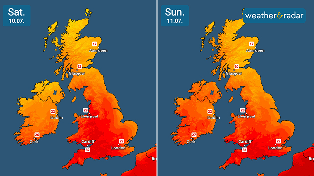
Split temperature maps of the UK and Ireland comparing Saturday 10.07 and Sunday 11.07 showing hot conditions across both countries. Temperatures reaching 32°C on Saturday and 31°C on Sunday in southern England, while Scotland remains cooler at 18 to 22°C.
Daily highs over the weekend remain in heatwave territory, but notably cooler along the east coasts.

Little change to be found in the outlook for the weekend as the heatwave continues, albeit feeling slightly cooler with a shift in the wind.

High pressure remains situated over the far north, with a northeasterly flow keeping things cooler as they have been throughout the heatwave period centred further south.

To the south of the UK, it remains largely dry, sunny, and hot across much of England and Wales. Ireland too sees higher temperatures approaching the high-20s to the south and west with yellow high temperature warnings in central to south-eastern areas.

The easterly winds also keep things cooler along the North Sea coasts while it remains cloudy with some patchy rain at times across Scotland.

Overall the hot spell continues into the new week for all countries, though the shift in wind direction will see peak temperatures shift slightly west, particularly in Ireland.

London

Fr
22
30
Sa
19
29
Su
18
28
Mo
16
26
Tu
19
30
We
20
31
Th
20
31
Fr
19
27
Sa
19
27
Su
18
28
Mo
17
27
Tu
17
25
We
16
24
Th
16
24
Max (°C)
Min (°C)
moreless

Manchester

Fr
15
32
Sa
18
29
Su
17
26
Mo
14
25
Tu
17
27
We
17
29
Th
18
27
Fr
17
25
Sa
16
24
Su
13
22
Mo
13
22
Tu
13
22
We
13
21
Th
12
20
Max (°C)
Min (°C)
moreless

Dublin

Fr
14
23
Sa
14
21
Su
17
21
Mo
16
20
Tu
16
21
We
17
22
Th
15
24
Fr
15
23
Sa
13
21
Su
12
21
Mo
11
20
Tu
10
19
We
11
19
Th
11
19
Max (°C)
Min (°C)
moreless

Edinburgh

Fr
14
22
Sa
15
16
Su
14
17
Mo
12
17
Tu
12
19
We
12
21
Th
12
22
Fr
15
23
Sa
14
21
Su
11
19
Mo
12
20
Tu
11
19
We
12
18
Th
11
18
Max (°C)
Min (°C)
moreless

Cardiff

Fr
16
33
Sa
20
32
Su
17
31
Mo
16
28
Tu
18
31
We
19
32
Th
20
28
Fr
18
26
Sa
17
25
Su
16
24
Mo
15
23
Tu
15
23
We
14
22
Th
13
21
Max (°C)
Min (°C)
moreless
Weather & Radar editorial team
More on the topic
Yet another typhoon in the Pacific. Gusts of over 185 mph. . . Friday, 3 July 2026
Wind forecast map of the western Pacific showing a powerful typhoon east of Guam with a well-defined eye, strong wind circulation, and a windsock warning icon.
Friday, 3 July 2026

Gusts of over 185 mph

Yet another typhoon in the Pacific
A sudden change in weather for Europe. Thunderstorms & tornadoes. . . Thursday, 2 July 2026
Split image showing a dramatic supercell thunderstorm with a lowering cloud base over farmland on the left, and a Europe lightning map on the right with dense lightning strikes and a thunderstorm warning symbol across central and southeastern Europe.
Thursday, 2 July 2026

Thunderstorms & tornadoes

A sudden change in weather for Europe
Summer in full flow. Your weather - Your shots. . . Sunday, 5 July 2026
Split image showing golden crepuscular rays streaming through sunset clouds over the countryside on the left, and glowing blue noctilucent clouds above silhouetted trees and traffic lights at twilight on the right.
Sunday, 5 July 2026

Your weather - Your shots

Summer in full flow
All weather news
This might also interest you
Huge waterspout on Lake Constance. Tornado over water. . . Thursday, 2 July 2026
A photograph of a waterspout over Lake Constance
Thursday, 2 July 2026

Tornado over water

Huge waterspout on Lake Constance
A hot and thundery week. Your weather - Your shots. . . Sunday, 28 June 2026
Split image showing a bright branching lightning bolt illuminating pink storm clouds on the left and a vivid rainbow arching above a rocky coastline and calm sea beneath dark clouds on the right.
Sunday, 28 June 2026

Your weather - Your shots

A hot and thundery week
Super Typhoon Bavi threatens Taiwan. Up to 1,000 mm of rain. . . Wednesday, 8 July 2026
The image shows an intense tropical cyclone over the western Pacific, east of Taiwan and the Philippines. The centre of the system is depicted as a light purple and white vortex with a clearly visible eye, surrounded by a ring of red and orange areas indicating the strongest wind speeds. A white arrow marks the typhoon’s predicted track towards the north-west, in the direction of Taiwan. To the west of the storm lie the Philippines, with the cities of Manila and Cebu; to the north of these lies Taiwan, with Taipei. Further west, the Chinese coast, including Hong Kong, and parts of Vietnam can be seen. The coloured wind map shows predominantly green areas outside the storm’s core, indicating significantly weaker winds. White streamlines illustrate the typhoon’s anti-clockwise circulation in the Northern Hemisphere. The highest wind speeds are concentrated around the eye of the cyclone.
Wednesday, 8 July 2026

Up to 1,000 mm of rain

Super Typhoon Bavi threatens Taiwan
All articles
Weather & Radar

Weather & Radar is also available on

Google Play StoreApp Store

Company

Contact us Privacy Policy Legal info Accessibility statement

Services

Uploader

Socials

facebooktwittertikToklinkList