Home
Weather London
WeatherRadar
RainfallRadar
TemperatureRadar
WindRadar
LightningRadar
Weather News
Editor's Pick
Discover the app
Weather widget
Contact us
Apps
Career
    Home /

    A changeable start to meteorological autumn is on the cards

15:28
31 August 2026

Weather Trend
Changeable start to September

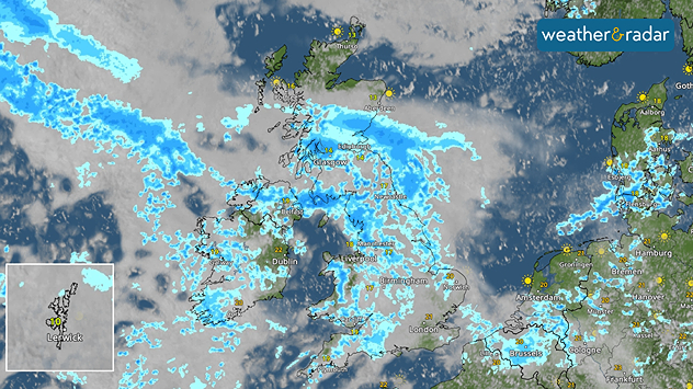
Weather radar image for Wednesday afternoon

A changeable start to September is on the cards across the UK and Ireland, with spells of rain and showers interspersed with some drier and brighter periods.

Tuesday looks largely dry and settled across much of England and Wales, although a few showers are possible in far western areas. Further north, cloud and rain will affect Scotland and parts of Ireland throughout the day and it will be breezy.

More widespread rain arrives into Wednesday as a new low approaches. A band of rain will move across parts of the UK, while Ireland starts wet in places before conditions turn brighter but showery from the west.

Thursday keeps the unsettled theme going. There will be a mix of sunny spells and scattered showers across the UK. Things will turn increasingly wet across Ireland as a new weather front arrives in the afternoon. Temperatures generally remain around normal, but it will feel warm in the southeast.

Heading towards Friday and the weekend, the finer details become less certain, but the broader pattern remains changeable.

Northern and western areas are most likely to see further rain and occasionally strong, gusty winds, while the south and east has the best chance of longer dry and bright spells.

Stay up to date with what's on the way with the WeatherRadar.

London

Mo
15
23
Tu
13
21
We
14
21
Th
19
26
Fr
20
24
Sa
16
22
Su
15
25
Mo
17
26
Tu
17
23
We
15
23
Th
16
24
Fr
16
24
Sa
16
22
Su
15
23
Max (°C)
Min (°C)
moreless

Leeds

Mo
14
21
Tu
12
20
We
15
18
Th
17
21
Fr
17
18
Sa
13
18
Su
11
21
Mo
15
23
Tu
13
20
We
9
19
Th
9
19
Fr
12
20
Sa
11
19
Su
9
19
Max (°C)
Min (°C)
moreless

Dublin

Mo
14
18
Tu
13
19
We
15
23
Th
16
21
Fr
15
18
Sa
11
17
Su
12
21
Mo
14
22
Tu
10
18
We
9
17
Th
12
20
Fr
14
19
Sa
11
17
Su
10
19
Max (°C)
Min (°C)
moreless

Edinburgh

Mo
13
19
Tu
13
18
We
12
14
Th
13
19
Fr
13
18
Sa
12
18
Su
11
18
Mo
16
20
Tu
11
18
We
9
17
Th
10
17
Fr
12
19
Sa
11
18
Su
11
18
Max (°C)
Min (°C)
moreless

Swansea

Mo
14
19
Tu
11
19
We
16
19
Th
18
21
Fr
18
19
Sa
13
18
Su
14
19
Mo
17
20
Tu
15
18
We
14
18
Th
15
18
Fr
16
19
Sa
15
18
Su
14
18
Max (°C)
Min (°C)
moreless

Lars Lowinski
More on the topic
Widespread thunderstorm risk in the UK. Heavy rain and hail too. . . Tuesday, 25 August 2026
Split weather graphic showing a yellow thunderstorm warning across much of England alongside radar with heavy showers and frequent lightning around London and southeast England.
Tuesday, 25 August 2026

Heavy rain and hail too

Widespread thunderstorm risk in the UK
Europe's storm situation still volatile. Supercell danger. . . Friday, 28 August 2026
Split screen. On the left, a weather map of Europe showing thunderstorms, lightning and a warning symbol. On the right, a photograph of a severe thunderstorm
Friday, 28 August 2026

Supercell danger

Europe's storm situation still volatile
Violent thunderstorms mark summer's end. Hail and gusts of wind. . . Thursday, 27 August 2026
Severe thunderstorm warning map showing a level 3 red zone from eastern France toward Belgium, surrounded by orange and yellow alerts extending into western Germany.
Thursday, 27 August 2026

Hail and gusts of wind

Violent thunderstorms mark summer's end
All weather news
This might also interest you
Record warmth in the Mediterranean. High water temperatures. . . Tuesday, 18 August 2026
Split graphic showing a hot southern Europe temperature map beside a sunny Mediterranean beach, with a sea-temperature icon highlighting very warm coastal waters.
Tuesday, 18 August 2026

High water temperatures

Record warmth in the Mediterranean
Severe weather risk in holiday spots. Hail and heavy rain. . . Wednesday, 19 August 2026
Split weather graphic showing intense thunderstorms and widespread lightning across northern Italy and Switzerland on the left, with severe warning zones from yellow to red around Milan and the southern Alps on the right.
Wednesday, 19 August 2026

Hail and heavy rain

Severe weather risk in holiday spots
Flood alerts after heavy showers. Risk in northern England. . . Thursday, 20 August 2026
Weather radar map showing persistent heavy rain across northern England around Liverpool, Manchester and Newcastle, with a flood warning symbol highlighting the risk.
Thursday, 20 August 2026

Risk in northern England

Flood alerts after heavy showers
All articles
Weather & Radar

Weather & Radar is also available on

Google Play StoreApp Store

Company

Contact us Privacy Policy Legal info Accessibility statement

Services

Uploader

Socials

facebooktwittertikToklinkList