Home
Weather London
WeatherRadar
RainfallRadar
TemperatureRadar
WindRadar
LightningRadar
Weather News
Editor's Pick
Discover the app
Weather widget
Contact us
Apps
Career
    Home / Editor's Pick /

    Over 30 degrees: record-breaking temperatures in the Mediterranean

08:58
18 August 2026

High water temperatures
Record warmth in the Mediterranean

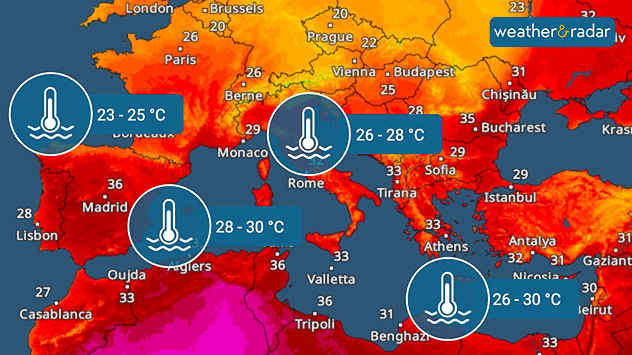
Sea temperature map of southern Europe and the Mediterranean showing 23–25°C near western France, 26–28°C around Italy and 26–30°C in the eastern Mediterranean, with 28–30°C near North Africa.
An overview of current water temperatures in Europe

The Mediterranean Sea has warmed up considerably in recent weeks and water temperatures are currently just under 2.5 degrees above the long-term average. In some places, the water is over 30°C.

This is due to a series of heatwaves and high-pressure weather with little wind. In most years, stronger winds, such as the Mistral, cause the sea to mix. This effect has been completely absent so far this summer.

The consequences could be devastating. Over the coming months, the weather in the Mediterranean will become more changeable and, above all, more prone to thunderstorms. The warmer the Mediterranean is, the greater the risk of severe weather.

24 days ago
24 days ago
Peter24 days ago
26 days ago
27 days ago
Carolina24 days ago
Weather & Radar editorial team
More on the topic
Hurricane Lowell threatens Hawaii. Gales and flash floods. . . Tuesday, 8 September 2026
WindRadar showing Hurricane Lowell north-west of Hawaii and its well-defined storm centre.
Tuesday, 8 September 2026

Gales and flash floods

Hurricane Lowell threatens Hawaii
Hottest summer on record for Ireland. Beating 2025's record. . . Thursday, 3 September 2026
Temperature map of Ireland showing 29°C in Dublin, 26°C in Cork, 24°C in Belfast, and 23°C in Galway, with a red thermometer icon.
Thursday, 3 September 2026

Beating 2025's record

Hottest summer on record for Ireland
Cheshire Gap produces shower funnel. Local phenomenon. . . Wednesday, 9 September 2026
Weather map showing showers moving southeast from Liverpool toward Birmingham, driven by Cheshire Gap convergence across central England.
Wednesday, 9 September 2026

Local phenomenon

Cheshire Gap produces shower funnel
All weather news
This might also interest you
Storm Chandra makes impact. Severe gales & heavy rain. . . Tuesday, 27 January 2026
Split image showing strong winds over the UK on a forecast map and widespread rain and snow on a weather radar map.
Tuesday, 27 January 2026

Severe gales & heavy rain

Storm Chandra makes impact
Long-term trends need a pinch of salt. 40 °C in July?. . . Tuesday, 30 June 2026
Temperature radar of 2022 heatwave where the all-time temperature record in the UK was set. Warning symbol overlain.
Tuesday, 30 June 2026

40 °C in July?

Long-term trends need a pinch of salt
Bright and warm conditions take hold. Spring-like outlook. . . Thursday, 23 April 2026
Split UK map showing warm temperatures up to 21 degrees in orange on the left and clear sunny conditions with temperatures from 12 to 18 degrees on the right, with sun icons across the country.
Thursday, 23 April 2026

Spring-like outlook

Bright and warm conditions take hold
All articles
Weather & Radar

Weather & Radar is also available on

Google Play StoreApp Store

Company

Contact us Privacy Policy Legal info Accessibility statement

Services

Uploader

Socials

facebooktwittertikToklinkList