Home
Weather London
WeatherRadar
RainfallRadar
TemperatureRadar
WindRadar
LightningRadar
Weather News
Editor's Pick
Discover the app
Weather widget
Contact us
Apps
Career
    Home / Editor's Pick /

    212.9 mph wind gusts: Typhoon Koinu breaks records in Taiwan

10:15
5 October 2023

212.9 mph wind gusts
Typhoon Koinu breaks records in Taiwan

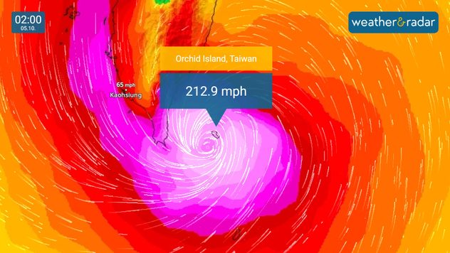
WindRadar showing Typhoon Koinu over Taiwan's Lanyu Island
Orchid Island saw the strongest wind gust ever recorded in Taiwan this morning.

Taiwan has provisionally recorded the strongest wind gust ever recorded in Asia, and the third strongest in the world, as Typhoon Koinu made impact overnight.

More than 300 people have been injured as Koinu brushed by the southern tip of Taiwan in the early hours, with one casualty reported.

A wind gust recorded at 212.9 mph on Taiwan's Orchid Island has provisionally become the strongest ever recorded in the country since records started, and the third strongest in the world.

The gust was so powerful it destroyed the island's anemometer as it passed.

Only speeds of 231 mph in New Hampshire, USA, and 253 mph on Australia's Barrow Island stand above last night's gusts internationally. While still offshore, the system saw sustained wind speeds of 130 mph, equivalent to a category 4 hurricane.

More than 60,000 properties lost power in the conditions, predominantly across Taiwan's western coast.

Felled tree on property
Tree blocking road
Closed bridge
Waves hit protective walls
1/4
Felled trees have resulted in property damage seen in Dawu, Taiwan. - © picture alliance

Heavy rainfall from the system fell mostly in mountainous regions, sparing more densely populated zones, although many cities in the south and east saw businesses and schools close ahead of Koinu's arrival.

Not a regular occurance

Koinu marks the second typhoon to make landfall in Taiwan this year, following Typhoon Haikui in September after a four-year break.

Koinu has now moved to the west of Taiwan, with western regions still seeing strong winds and rainfall.

It will continue moving west before likely making landfall in China in the early hours of Saturday.

Ryan Hathaway
More on the topic
New heatwave in southern Europe. Up to 45 degrees in Spain. . . Tuesday, 21 July 2026
Split temperature map showing extreme heat across Spain on the left and Greece on the right, with temperatures reaching 44°C near Murcia, around 40°C in parts of Greece, and a large thermometer icon highlighting dangerous heat.
Tuesday, 21 July 2026

Up to 45 degrees in Spain

New heatwave in southern Europe
Drought for North Wales and Upper Severn. 2% of average rainfall. . . Thursday, 23 July 2026
Split image showing a July rainfall anomaly map of Europe on the left with below-average rainfall across the UK, Ireland, and much of western and central Europe, and an active moorland wildfire on the right producing flames and thick smoke near homes.
Thursday, 23 July 2026

2% of average rainfall

Drought for North Wales and Upper Severn
Long-term trends need a pinch of salt. Heading over 40°C?. . . Tuesday, 21 July 2026
Temperature radar of 2022 heatwave where the all-time temperature record in the UK was set. Warning symbol overlain.
Tuesday, 21 July 2026

Heading over 40°C?

Long-term trends need a pinch of salt
All weather news
This might also interest you
New records for England and Wales. Broken again tomorrow?. . . Thursday, 25 June 2026
Temperature map of southwest Britain on 25.06 showing extreme heat across southern Wales and southwest England, with Bute Park in Cardiff highlighted at 34.2°C and Yeovilton at 36.4°C amid widespread deep red heat zones.
Thursday, 25 June 2026

Broken again tomorrow?

New records for England and Wales
Seasonal warmth between spring thunder. Your weather - Your shots. . . Sunday, 19 April 2026
Split image showing coastal sunset with layered lenticular clouds over rooftops and palm trees on the left, and a green valley with river and hills under soft daylight on the right.
Sunday, 19 April 2026

Your weather - Your shots

Seasonal warmth between spring thunder
Bright and warm conditions take hold. Spring-like outlook. . . Thursday, 23 April 2026
Split UK map showing warm temperatures up to 21 degrees in orange on the left and clear sunny conditions with temperatures from 12 to 18 degrees on the right, with sun icons across the country.
Thursday, 23 April 2026

Spring-like outlook

Bright and warm conditions take hold
All articles
Weather & Radar

Weather & Radar is also available on

Google Play StoreApp Store

Company

Contact us Privacy Policy Legal info Accessibility statement

Services

Uploader

Socials

facebooktwittertikToklinkList