Home
Weather London
WeatherRadar
RainfallRadar
TemperatureRadar
WindRadar
LightningRadar
Weather News
Editor's Pick
Discover the app
Weather widget
Contact us
Apps
Career
    Home / Editor's Pick /

    Your weather - Your shots - Autumn captured by you

09:00
9 December 2025

Your weather - Your shots
Autumn captured by you

Dark, heavy storm clouds with a textured, turbulent appearance loom over a rural landscape with trees and fields.
Dark storm clouds hang over a town at sunset, with streaks of rain falling from the clouds while the sun shines brightly through the golden sky.
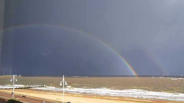
A double rainbow arcs over the sea, with dark grey storm clouds in the background and waves breaking onto a sandy beach in the foreground.
A large rain cloud hangs over the sea, with heavy precipitation visible beneath it. Dark and light grey clouds spread across the sky, with small patches of blue breaking through.
A sunlit mountain with patches of grass and rock is reflected clearly in a still lake, creating a near-perfect mirror image under a partly cloudy sky.
Wide view of a grassy meadow bordered by trees under a vivid pink and orange sunset sky with streaked clouds.
Two small bird statues perched on a post in silhouette against a vivid orange and pink sunset sky with layered clouds above grassy foreground.
Double rainbow arching over a rocky shoreline with waves curving along a sandy beach under dark and bright mixed clouds.
High wispy cirrus clouds streaking across a deep blue sky, with a small distant aircraft visible near the upper right.
Large offshore wind turbine silhouetted against a vivid orange sunset with the sun partially below the horizon over calm sea.
Northern Lights over Dublin, Ireland
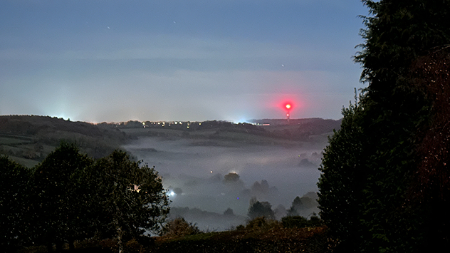
Evening view over Bledlow Ridge, Buckinghamshire showing dense fog settled in the valley under a clear sky, with a red tower light and distant village lights visible.
Wave-shaped Kelvin-Helmholtz clouds forming above the England–Scotland border, viewed from a roadside with railings and power lines.
Golden-orange sunset over Inverness with streaked clouds and rain bands, reflected on the curved surface of a modern bridge.
1/14
Dark storm clouds gathered over Elton, Cheshire in September. - © Marion Beers

Autumn provided plenty of snapshot worthy scenes across the UK and Ireland, with storms, auroras, and pleasant sunny vistas too.

Take a trip back through the season with a selection of captures sent in over the past few months by you, our users!

Want to be included in the winter round-up? Send in your pictures throughout the season via the uploaders for the UK or Ireland.

Weather & Radar editorial team
More on the topic
Drought for North Wales and Upper Severn. 2% of average rainfall. . . Thursday, 23 July 2026
Split image showing a July rainfall anomaly map of Europe on the left with below-average rainfall across the UK, Ireland, and much of western and central Europe, and an active moorland wildfire on the right producing flames and thick smoke near homes.
Thursday, 23 July 2026

2% of average rainfall

Drought for North Wales and Upper Severn
Rain returns to end dry spell in places. Jet stream delivery. . . Thursday, 23 July 2026
Split weather graphic showing widespread showers across the UK and Ireland on the left, and a wind forecast map on the right with a windsock icon and gusts of 25 to 35 mph, highlighting breezy conditions across the two countries.
Thursday, 23 July 2026

Jet stream delivery

Rain returns to end dry spell in places
New heatwave in southern Europe. Up to 45 degrees in Spain. . . Tuesday, 21 July 2026
Split temperature map showing extreme heat across Spain on the left and Greece on the right, with temperatures reaching 44°C near Murcia, around 40°C in parts of Greece, and a large thermometer icon highlighting dangerous heat.
Tuesday, 21 July 2026

Up to 45 degrees in Spain

New heatwave in southern Europe
All weather news
This might also interest you
Super Typhoon Bavi threatens Taiwan. Up to 1,000 mm of rain. . . Wednesday, 8 July 2026
The image shows an intense tropical cyclone over the western Pacific, east of Taiwan and the Philippines. The centre of the system is depicted as a light purple and white vortex with a clearly visible eye, surrounded by a ring of red and orange areas indicating the strongest wind speeds. A white arrow marks the typhoon’s predicted track towards the north-west, in the direction of Taiwan. To the west of the storm lie the Philippines, with the cities of Manila and Cebu; to the north of these lies Taiwan, with Taipei. Further west, the Chinese coast, including Hong Kong, and parts of Vietnam can be seen. The coloured wind map shows predominantly green areas outside the storm’s core, indicating significantly weaker winds. White streamlines illustrate the typhoon’s anti-clockwise circulation in the Northern Hemisphere. The highest wind speeds are concentrated around the eye of the cyclone.
Wednesday, 8 July 2026

Up to 1,000 mm of rain

Super Typhoon Bavi threatens Taiwan
Historic Storm Éowyn arrives. On this day.... . . Saturday, 24 January 2026
Split image showing a person in a yellow jacket struggling against strong winds and heavy rain on a street at night on the left, and an Irish wind forecast map on the right with red and purple shading, gusts up to 75 mph, and a wind warning icon, divided by a curved white line.
Saturday, 24 January 2026

On this day...

Historic Storm Éowyn arrives
New records for England and Wales. Broken again tomorrow?. . . Thursday, 25 June 2026
Temperature map of southwest Britain on 25.06 showing extreme heat across southern Wales and southwest England, with Bute Park in Cardiff highlighted at 34.2°C and Yeovilton at 36.4°C amid widespread deep red heat zones.
Thursday, 25 June 2026

Broken again tomorrow?

New records for England and Wales
All articles
Weather & Radar

Weather & Radar is also available on

Google Play StoreApp Store

Company

Contact us Privacy Policy Legal info Accessibility statement

Services

Uploader

Socials

facebooktwittertikToklinkList