Home
Weather London
WeatherRadar
RainfallRadar
TemperatureRadar
WindRadar
LightningRadar
Weather News
Editor's Pick
Discover the app
Weather widget
Contact us
Apps
Career
    Home / Editor's Pick /

    Winter takes a break – weather conditions undergo fundamental change

10:25
24 November 2025

Winter takes a break
Weather conditions change dramatically

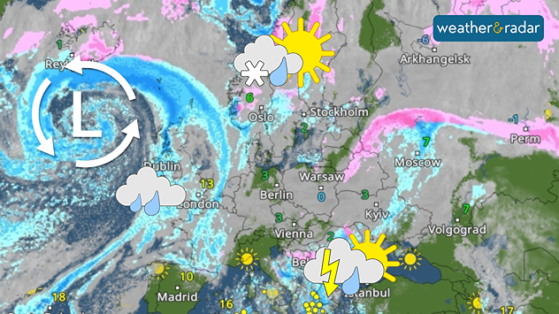
Thursday's WeatherRadar clearly shows the Atlantic low pressure system bringing major weather changes to Europe.

After the brief winter interlude, signs now point to mild weather. The general weather situation is changing and putting winter on hold for the time being.

From the second half of the week onwards, low-pressure systems from the Atlantic will increasingly prevail. Not only will they bring changeable weather, but they will also draw warm air from North Africa. This means that a significant rise in temperature is on the way.

Snow fans now need a lot of patience

Maximum temperatures in Western Europe will rise to 10 to 15 degrees, and even higher in the warmest regions of Spain and Portugal. But it will also become milder in Scandinavia: instead of persistent frost, temperatures above zero will be common, with only the far north experiencing light frost.

Once established, these weather conditions are likely to persist. Atlantic lows will remain active, with highs from the east having little chance of developing.

For snow fans, this means patience is required – conditions are likely to remain mild and often wet well into December.

London

Mo
9
17
Tu
14
16
We
8
16
Th
9
15
Fr
8
14
Sa
10
14
Su
8
14
Mo
9
14
Tu
11
16
We
11
16
Th
10
16
Fr
13
15
Sa
9
14
Su
10
13
Max (°C)
Min (°C)
moreless

Birmingham

Mo
7
16
Tu
12
13
We
8
15
Th
9
12
Fr
9
12
Sa
8
14
Su
5
11
Mo
6
12
Tu
9
13
We
9
14
Th
8
14
Fr
10
12
Sa
5
11
Su
7
11
Max (°C)
Min (°C)
moreless

Dublin

Mo
7
18
Tu
9
12
We
9
16
Th
7
14
Fr
13
15
Sa
6
12
Su
6
12
Mo
8
11
Tu
7
11
We
7
12
Th
8
12
Fr
7
10
Sa
6
11
Su
6
10
Max (°C)
Min (°C)
moreless

Edinburgh

Mo
7
15
Tu
11
11
We
8
13
Th
7
13
Fr
9
12
Sa
7
13
Su
7
13
Mo
10
13
Tu
7
12
We
8
12
Th
8
12
Fr
7
11
Sa
5
10
Su
7
11
Max (°C)
Min (°C)
moreless

Cardiff

Mo
8
16
Tu
12
13
We
10
15
Th
10
14
Fr
9
14
Sa
10
14
Su
7
12
Mo
9
13
Tu
10
13
We
11
13
Th
11
14
Fr
12
13
Sa
9
13
Su
9
12
Max (°C)
Min (°C)
moreless

Belfast

Mo
6
17
Tu
9
12
We
9
15
Th
7
14
Fr
12
14
Sa
7
11
Su
6
12
Mo
9
11
Tu
7
11
We
7
12
Th
8
11
Fr
6
10
Sa
7
11
Su
7
11
Max (°C)
Min (°C)
moreless
Jürgen Vollmer
Ryan Hathaway

More on the topic

Storm Boelo named. Weekend impacts. . . Thursday, 22 October 2026
Split weather maps showing Storm Boelo northwest of Scotland, winds reaching 50 mph near Glasgow and Liverpool, and spiralling Atlantic rain bands.
Thursday, 22 October 2026

Weekend impacts

Storm Boelo named
Calmer autumn views on a stormy week. Your weather - Your shots. . . Sunday, 25 October 2026
Split image showing swirling orange-pink sunset clouds above green countryside and golden wispy clouds over a tree-lined car park.
Sunday, 25 October 2026

Your weather - Your shots

Calmer autumn views on a stormy week
Overnight impacts as Austen hits. Power cuts, travel issues. . . Friday, 23 October 2026
Split image showing floodwater surging beneath a railway bridge at night and a wind map with low pressure over the English Channel and 60 mph near Brest.
Friday, 23 October 2026

Power cuts, travel issues

Overnight impacts as Austen hits
All weather news

This might also interest you

New records for England and Wales. Broken again tomorrow?. . . Thursday, 25 June 2026
Temperature map of southwest Britain on 25.06 showing extreme heat across southern Wales and southwest England, with Bute Park in Cardiff highlighted at 34.2°C and Yeovilton at 36.4°C amid widespread deep red heat zones.
Thursday, 25 June 2026

Broken again tomorrow?

New records for England and Wales
A frozen start to the weekend. Icy conditions. . . Friday, 13 February 2026
UK temperature map dated 14.02 showing widespread subzero values in blue shading, with readings such as −4 in Glasgow, −3 in Dublin, and −2 in London, alongside a blue thermometer icon.
Friday, 13 February 2026

Icy conditions

A frozen start to the weekend
Bright and warm conditions take hold. Spring-like outlook. . . Thursday, 23 April 2026
Split UK map showing warm temperatures up to 21 degrees in orange on the left and clear sunny conditions with temperatures from 12 to 18 degrees on the right, with sun icons across the country.
Thursday, 23 April 2026

Spring-like outlook

Bright and warm conditions take hold
All articles
Weather & Radar

Weather & Radar is also available on

Google Play StoreApp Store

Company

Contact us Privacy Policy Legal info Accessibility statement

Services

Uploader

Socials

facebooktwittertikToklinkList