Home
Weather London
WeatherRadar
RainfallRadar
TemperatureRadar
WindRadar
LightningRadar
Weather News
Editor's Pick
Discover the app
Weather widget
Contact us
Apps
Career
    Home / Editor's Pick /

    Warnings in place - Winds pick up for gusty Thursday

15:00
29 October 2025

Warnings in place
Winds pick up for gusty Thursday

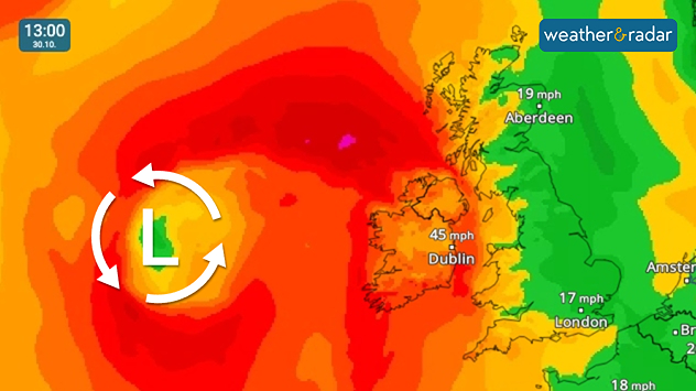
Winds first grow stronger across Ireland through the morning.

The unsettled weather continues on Thursday as a passing low brings a return of stronger winds.

First, growing gusty across Ireland through the morning. Peaking at highs of around 55 mph (90 km/h) from Belmullet to Dublin and in the south too.

Later in the day, the winds also become widespread across the UK. Alongside sweeping bands of heavy rain.

Warnings are in place across Ireland and parts of the UK.

Keep track with the WindRadar
Ryan Hathaway
More on the topic
Cooler nights on the horizon. For parts of Europe. . . Thursday, 6 August 2026
Temperature Radar showing the night-time lows in Central Europe. Cooler air is reaching the west and north in particular, whilst the south-east remains significantly warmer.
Thursday, 6 August 2026

For parts of Europe

Cooler nights on the horizon
Poor harvest expected after drought. Rain remains scarce. . . Thursday, 6 August 2026
Split image showing an aerial view of drought-stricken parkland with dry yellow-brown grass surrounding a church on the left, and a temperature map of England and Wales on the right with temperatures reaching 30°C in southeast England.
Thursday, 6 August 2026

Rain remains scarce

Poor harvest expected after drought
Stronger winds make a return. Low pressure influence. . . Tuesday, 4 August 2026
Wind forecast map of the UK and Ireland showing a low-pressure system north of Scotland, a windsock icon highlighting blustery conditions, and widespread winds of 30–40 mph across the British Isles, with the strongest winds around Ireland and northern Britain.
Tuesday, 4 August 2026

Low pressure influence

Stronger winds make a return
All weather news
This might also interest you
Storm Chandra makes impact. Severe gales & heavy rain. . . Tuesday, 27 January 2026
Split image showing strong winds over the UK on a forecast map and widespread rain and snow on a weather radar map.
Tuesday, 27 January 2026

Severe gales & heavy rain

Storm Chandra makes impact
New records for England and Wales. Broken again tomorrow?. . . Thursday, 25 June 2026
Temperature map of southwest Britain on 25.06 showing extreme heat across southern Wales and southwest England, with Bute Park in Cardiff highlighted at 34.2°C and Yeovilton at 36.4°C amid widespread deep red heat zones.
Thursday, 25 June 2026

Broken again tomorrow?

New records for England and Wales
Historic Storm Éowyn arrives. On this day.... . . Saturday, 24 January 2026
Split image showing a person in a yellow jacket struggling against strong winds and heavy rain on a street at night on the left, and an Irish wind forecast map on the right with red and purple shading, gusts up to 75 mph, and a wind warning icon, divided by a curved white line.
Saturday, 24 January 2026

On this day...

Historic Storm Éowyn arrives
All articles
Weather & Radar

Weather & Radar is also available on

Google Play StoreApp Store

Company

Contact us Privacy Policy Legal info Accessibility statement

Services

Uploader

Socials

facebooktwittertikToklinkList