Home
Weather London
WeatherRadar
RainfallRadar
TemperatureRadar
WindRadar
LightningRadar
Weather News
Editor's Pick
Discover the app
Weather widget
Contact us
Apps
Career
    Home / Editor's Pick /

    Warnings active - Stormy Wednesday ahead

11:00
2 September 2025

Warnings active
Stormy Wednesday ahead

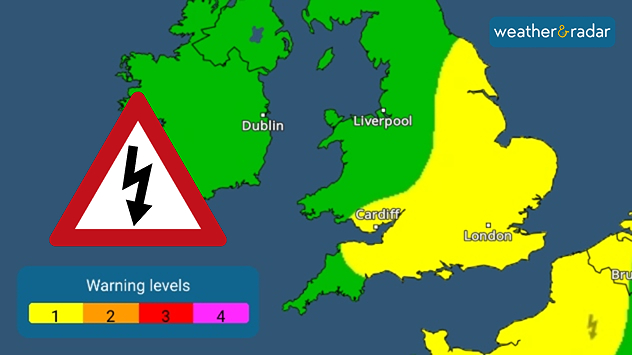
Weather warning map highlighting thunderstorm alerts: much of southern and eastern England, along with south Wales, is shaded yellow for level 1 warnings, while Ireland and northern England remain clear. A thunderstorm hazard warning symbol is shown on the left.
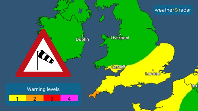
Weather warning map highlighting wind alerts: southern England and south Wales are shaded yellow for level 1 warnings, while a small coastal area in the far south-west is shaded orange for level 2 warnings. A wind hazard warning symbol is displayed on the left.
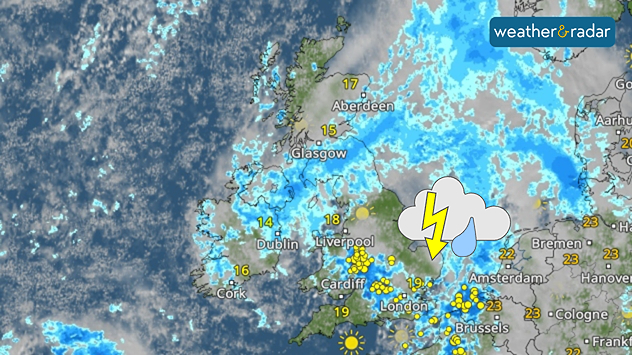
Weather map of the UK and nearby Europe showing widespread rain across much of Britain and Ireland, with heavier showers and thunderstorms marked over south-east England and northern France. Temperatures range from 14°C in Dublin to 19°C in London and Cardiff, with brighter conditions in the far south.
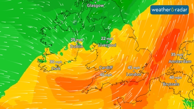
Wind map of the UK, Ireland, and nearby Europe showing stronger gusts in southern areas. London is marked with 45 mph, Cardiff 40 mph, and Cork 30 mph, while Dublin and Liverpool show lighter winds at 25 mph and 22 mph. The background colours shift from green in the north to orange and red in the south, highlighting the strongest winds over southern England and the Low Countries.
1/4
Thunderstorm warnings for Wednesday.

Multiple weather warnings are active for Wednesday, which looks set to be a wet and windy one for much of the UK.

The unsettled conditions begin in the early morning, with southern England, Wales, and parts of Ireland seeing a wet and windy morning commute.

Changing warnings

Weather warnings with Weather & Radar can change based on the latest outlook, and could have eased or worsened. 

Check the outlook on the radar
Ryan Hathaway
More on the topic
Heat becoming a bigger factor in drought. New study. . . Thursday, 23 July 2026
A hand holds dry, dusty earth above a parched field. The ground is cracked and covered with plant debris – a sign of prolonged drought.
Thursday, 23 July 2026

New study

Heat becoming a bigger factor in drought
Heatwave breaks after remarkable run. Two weeks of heat. . . Monday, 20 July 2026
Split image showing the London skyline in hazy golden sunshine on the left and a July temperature anomaly map of Europe on the right, with above-average temperatures across the UK, Ireland, and much of western Europe highlighted in red alongside a thermometer icon.
Monday, 20 July 2026

Two weeks of heat

Heatwave breaks after remarkable run
Parts of England inching towards drought. Low rivers & reservoirs. . . Wednesday, 22 July 2026
People relaxing in a park during hot weather ,with one person sunbathing on dry yellow grass beneath large leafy trees under a blue sky with scattered fair-weather clouds.
Wednesday, 22 July 2026

Low rivers & reservoirs

Parts of England inching towards drought
All weather news
This might also interest you
Bright and warm conditions take hold. Spring-like outlook. . . Thursday, 23 April 2026
Split UK map showing warm temperatures up to 21 degrees in orange on the left and clear sunny conditions with temperatures from 12 to 18 degrees on the right, with sun icons across the country.
Thursday, 23 April 2026

Spring-like outlook

Bright and warm conditions take hold
Flooding, gales, and heavy snow. Storm Chandra. . . Tuesday, 27 January 2026
Split image showing aerial flooding in a town with muddy water covering roads on the left, and a rural road on the right blocked by heavy snowfall with vans stopped and a person walking in snow.
Tuesday, 27 January 2026

Storm Chandra

Flooding, gales, and heavy snow
Historic Storm Éowyn arrives. On this day.... . . Saturday, 24 January 2026
Split image showing a person in a yellow jacket struggling against strong winds and heavy rain on a street at night on the left, and an Irish wind forecast map on the right with red and purple shading, gusts up to 75 mph, and a wind warning icon, divided by a curved white line.
Saturday, 24 January 2026

On this day...

Historic Storm Éowyn arrives
All articles
Weather & Radar

Weather & Radar is also available on

Google Play StoreApp Store

Company

Contact us Privacy Policy Legal info Accessibility statement

Services

Uploader

Socials

facebooktwittertikToklinkList