Home
Weather London
WeatherRadar
RainfallRadar
TemperatureRadar
WindRadar
LightningRadar
Weather News
Editor's Pick
Discover the app
Weather widget
Contact us
Apps
Career
    Home / Editor's Pick /

    Two weeks of heat - Heatwave breaks after remarkable run

08:00
20 July 2026

Two weeks of heat
Heatwave breaks after remarkable run

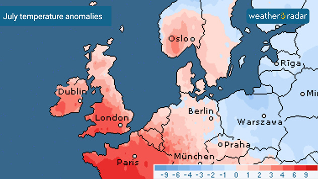
July temperature anomaly map of Europe showing above-average temperatures across the UK, Ireland, France, Germany, and Scandinavia in red shades, while eastern Europe displays below-average temperatures in blue.
This heatwave pushed July's temperature anomalies even higher.

The third heatwave of the year broke over the weekend, ending a remarkable spell of daily highs and rain totals... or lack thereof.

Parts of the UK remained in heatwave conditions for two weeks by the time the temperatures fell.

While the infamous 1976 heatwave lasted for 16 days, Bournemouth came close with 14 days in a row, while a high of 31.3°C in Herefordshire on Friday resulted in the 13th consecutive day of temperatures passing 30°C.

It wasn't just the heat, but a prolonged dry spell too, pushing parts of the country towards drought and resulting in water usage restrictions.

Parts of England have gone 30 days without any rainfall with central England experiencing the longest dry spell for three decades.

While high pressure remains in charge, the chance of rain or showers grows as we head into August.

Ryan Hathaway
More on the topic
Heatwave keeps a firm grip on Europe. Around 40°C in places. . . Monday, 13 July 2026
A collage featuring a temperature radar map of Europe and a fire-fighting aircraft in action over a forest fire. In the centre, a heat symbol warns of persistently high temperatures.
Monday, 13 July 2026

Around 40°C in places

Heatwave keeps a firm grip on Europe
Sea fog rolls into Pembrokeshire. Unique summer scene. . . Tuesday, 14 July 2026
Thick sea fog rolling inland over a sunlit bay, with sparkling water, trees and garden in the foreground, and a hill rising above the fog under a clear blue sky.
Tuesday, 14 July 2026

Unique summer scene

Sea fog rolls into Pembrokeshire
Wildfires break out amid ongoing drought. Water restrictions active. . . Tuesday, 14 July 2026
Smoke rising from a scorched moorland hillside after a wildfire, with blackened vegetation, smouldering ground, and drifting gray smoke covering the burned landscape.
Tuesday, 14 July 2026

Water restrictions active

Wildfires break out amid ongoing drought
All weather news
This might also interest you
Bright and warm conditions take hold. Spring-like outlook. . . Thursday, 23 April 2026
Split UK map showing warm temperatures up to 21 degrees in orange on the left and clear sunny conditions with temperatures from 12 to 18 degrees on the right, with sun icons across the country.
Thursday, 23 April 2026

Spring-like outlook

Bright and warm conditions take hold
Storm Chandra makes impact. Severe gales & heavy rain. . . Tuesday, 27 January 2026
Split image showing strong winds over the UK on a forecast map and widespread rain and snow on a weather radar map.
Tuesday, 27 January 2026

Severe gales & heavy rain

Storm Chandra makes impact
A frozen start to the weekend. Icy conditions. . . Friday, 13 February 2026
UK temperature map dated 14.02 showing widespread subzero values in blue shading, with readings such as −4 in Glasgow, −3 in Dublin, and −2 in London, alongside a blue thermometer icon.
Friday, 13 February 2026

Icy conditions

A frozen start to the weekend
All articles
Weather & Radar

Weather & Radar is also available on

Google Play StoreApp Store

Company

Contact us Privacy Policy Legal info Accessibility statement

Services

Uploader

Socials

facebooktwittertikToklinkList