Home
Weather London
WeatherRadar
RainfallRadar
TemperatureRadar
WindRadar
LightningRadar
Weather News
Editor's Pick
Discover the app
Weather widget
Contact us
Apps
Career
    Home / Weather News /

    Turkey earthquake update: Death toll rises over 50,000

12:40
7 February 2023

Turkey earthquake update
Death toll rises over 50,000

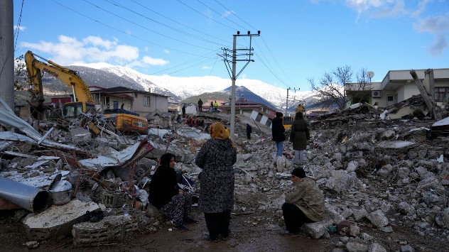
People sit on rubble after earthquake
People sit on the rubble as emergency rescue teams search beneath destroyed buildings in Nurdagi on February 7th. - © picture alliance

The death toll in Turkey is continuing to rise following the devastating earthquake on Monday February 6th.

The initial earthquake struck south-east Turkey as a 7.8 magnitude quake, according to USGS. Several aftershocks then followed, including a second earthquake of 7.5 magnitude in the same region, less than 12 hours later.

Several provinces are affected, thousands of buildings collapsed. Rescue teams were brought together from all over the country. So far there have been over 240 aftershocks.

Experts from the Kandilli earthquake station in Istanbul speak of the strongest earthquake in Turkey for decades. According to EU officials, it was one of the strongest in the region in more than 100 years. The country is repeatedly affected by severe earthquakes.

Two of the largest continental plates meet in the affected regions: the African and the Eurasian. In fact, most of the Turkish population lives in constant danger of earthquakes.

On Monday February 6th 2023, the numerous earthquakes occurred along a fracture zone running from southwest to northeast.

Researchers say the possibility for major aftershocks could continue for weeks and months. Harsh winter weather is worsening the situation; sub-zero temperatures will be persisting, but the risk of snow on the WeatherRadar is now reducing.

Currently, snow and freezing conditions are affecting the region, with the death toll expected to rise further as people remain trapped under rubble outside. The World Health Organisation anticipate the number to rise eight-fold.

Weather & Radar editorial team
More on the topic
Record warmth in the Mediterranean. High water temperatures. . . Tuesday, 18 August 2026
Split graphic showing a hot southern Europe temperature map beside a sunny Mediterranean beach, with a sea-temperature icon highlighting very warm coastal waters.
Tuesday, 18 August 2026

High water temperatures

Record warmth in the Mediterranean
Drought brings flash flood risks. As rain returns. . . Wednesday, 19 August 2026
Weather radar map of the UK and Ireland showing widespread showers, with a rain icon and flood warning symbol highlighting the risk from rainfall.
Wednesday, 19 August 2026

As rain returns

Drought brings flash flood risks
Lightning strikes in dry conditions. Positive earth flashes. . . Monday, 17 August 2026
On the left, massive thunderclouds are gathering at night, with several flashes of lightning streaking from them. On the right, a map shows the Ligurian coast near Genoa and Savona. Numerous coloured dots over the Ligurian Sea and along the coast indicate lightning activity.
Monday, 17 August 2026

Positive earth flashes

Lightning strikes in dry conditions
All weather news
This might also interest you
New records for England and Wales. Broken again tomorrow?. . . Thursday, 25 June 2026
Temperature map of southwest Britain on 25.06 showing extreme heat across southern Wales and southwest England, with Bute Park in Cardiff highlighted at 34.2°C and Yeovilton at 36.4°C amid widespread deep red heat zones.
Thursday, 25 June 2026

Broken again tomorrow?

New records for England and Wales
Super Typhoon Bavi threatens Taiwan. Up to 1,000 mm of rain. . . Wednesday, 8 July 2026
The image shows an intense tropical cyclone over the western Pacific, east of Taiwan and the Philippines. The centre of the system is depicted as a light purple and white vortex with a clearly visible eye, surrounded by a ring of red and orange areas indicating the strongest wind speeds. A white arrow marks the typhoon’s predicted track towards the north-west, in the direction of Taiwan. To the west of the storm lie the Philippines, with the cities of Manila and Cebu; to the north of these lies Taiwan, with Taipei. Further west, the Chinese coast, including Hong Kong, and parts of Vietnam can be seen. The coloured wind map shows predominantly green areas outside the storm’s core, indicating significantly weaker winds. White streamlines illustrate the typhoon’s anti-clockwise circulation in the Northern Hemisphere. The highest wind speeds are concentrated around the eye of the cyclone.
Wednesday, 8 July 2026

Up to 1,000 mm of rain

Super Typhoon Bavi threatens Taiwan
Flooding, gales, and heavy snow. Storm Chandra. . . Tuesday, 27 January 2026
Split image showing aerial flooding in a town with muddy water covering roads on the left, and a rural road on the right blocked by heavy snowfall with vans stopped and a person walking in snow.
Tuesday, 27 January 2026

Storm Chandra

Flooding, gales, and heavy snow
All articles
Weather & Radar

Weather & Radar is also available on

Google Play StoreApp Store

Company

Contact us Privacy Policy Legal info Accessibility statement

Services

Uploader

Socials

facebooktwittertikToklinkList