Home
Weather London
WeatherRadar
RainfallRadar
TemperatureRadar
WindRadar
LightningRadar
Weather News
Editor's Pick
Discover the app
Weather widget
Contact us
Apps
Career
    Home / Editor's Pick /

    Tropical storm threatens New Zealand – Vaianu brings heavy rain, gale-force winds, and high waves

09:50
10 April 2026

Vaianu brings heavy rain
Tropical storm threatens New Zealand

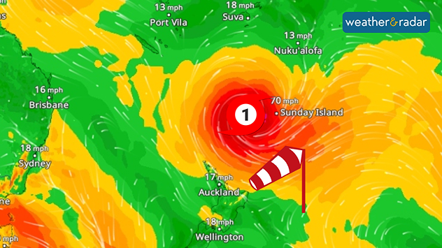
WindRadar: A tropical storm is heading towards New Zealand, bringing storm-force and gale-force winds.

A tropical storm named Vaianu is currently approaching the north of New Zealand. The centre of the storm is still over the sea, but its effects will soon be felt.

Although Vaianu will weaken slightly by Saturday, it will transform into a subtropical storm. This means it will be less compact, but significantly more extensive and unpredictable. Wind gusts of up to 75 miles per hour are still possible.

In addition, the storm system is continuing to spread. It will start affecting the north coast from Saturday evening, and during the night leading into Sunday, the ex-cyclone will move across the North Island. It will therefore affect several regions at once, not just a narrow strip.

Did you know?

Cyclone Gabrielle battered the region three years ago and was one of the costliest storms in New Zealand’s history. It brought torrential rain and caused massive damage.

There are multiple risks: heavy rain causing flooding and landslides, plus severe gusts of wind and high waves along the coast. Power cuts and transport disruption are also highly likely.

Weather & Radar editorial team
More on the topic
Long-term trends need a pinch of salt. Heading over 40°C?. . . Tuesday, 21 July 2026
Temperature radar of 2022 heatwave where the all-time temperature record in the UK was set. Warning symbol overlain.
Tuesday, 21 July 2026

Heading over 40°C?

Long-term trends need a pinch of salt
Heat becoming a bigger factor in drought. New study. . . Thursday, 23 July 2026
A hand holds dry, dusty earth above a parched field. The ground is cracked and covered with plant debris – a sign of prolonged drought.
Thursday, 23 July 2026

New study

Heat becoming a bigger factor in drought
New heatwave in southern Europe. Up to 45 degrees in Spain. . . Tuesday, 21 July 2026
Split temperature map showing extreme heat across Spain on the left and Greece on the right, with temperatures reaching 44°C near Murcia, around 40°C in parts of Greece, and a large thermometer icon highlighting dangerous heat.
Tuesday, 21 July 2026

Up to 45 degrees in Spain

New heatwave in southern Europe
All weather news
This might also interest you
Storm Chandra makes impact. Severe gales & heavy rain. . . Tuesday, 27 January 2026
Split image showing strong winds over the UK on a forecast map and widespread rain and snow on a weather radar map.
Tuesday, 27 January 2026

Severe gales & heavy rain

Storm Chandra makes impact
A frozen start to the weekend. Icy conditions. . . Friday, 13 February 2026
UK temperature map dated 14.02 showing widespread subzero values in blue shading, with readings such as −4 in Glasgow, −3 in Dublin, and −2 in London, alongside a blue thermometer icon.
Friday, 13 February 2026

Icy conditions

A frozen start to the weekend
Historic Storm Éowyn arrives. On this day.... . . Saturday, 24 January 2026
Split image showing a person in a yellow jacket struggling against strong winds and heavy rain on a street at night on the left, and an Irish wind forecast map on the right with red and purple shading, gusts up to 75 mph, and a wind warning icon, divided by a curved white line.
Saturday, 24 January 2026

On this day...

Historic Storm Éowyn arrives
All articles
Weather & Radar

Weather & Radar is also available on

Google Play StoreApp Store

Company

Contact us Privacy Policy Legal info Accessibility statement

Services

Uploader

Socials

facebooktwittertikToklinkList