Home
Weather London
WeatherRadar
RainfallRadar
TemperatureRadar
WindRadar
LightningRadar
Weather News
Editor's Pick
Discover the app
Weather widget
Contact us
Apps
Career
    Home / Editor's Pick /

    To the north - Northern Lights could shine tonight

17:00
13 May 2026

To the north
Northern Lights could shine tonight

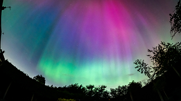
The night sky glows with vivid aurora colours, showing bright green bands near the horizon blending into purple and pink streaks higher up. Dark silhouettes of trees frame the bottom of the scene.
A particularly strong aurora pictured in Solihull in 2025. - © Spencer Salter

The arrival of a solar particles Wednesday evening brings a chance to see the always awe-inspiring Northern Lights in the north of the UK.

This display, also known as the Aurora Borealis, is produced by particles emitted by the Sun impacting the Earth's atmosphere. On Sunday, the Sun produced a large coronal mass ejection which is set to arrive Wednesday night.

The Northern Lights can often be spotted in Scotland, but with stronger events like tonight, they can be seen further south too... if the skies are clear.

Much like the day, there is still rain moving through the UK and Ireland by the evening, but pockets of visibility open up.

Can't see them? Maybe you can

Swirling trails of greens and reds are the typically pictured scenes from an aurora, but they can be invisible to the naked eye. Try taking a long-exposure of the evening sky to capture any activity.

Like all astronomical events, it is easier to spot the Northern Lights in areas away from artificial light, which can mask the night sky.

Ryan Hathaway
More on the topic
Cooler nights on the horizon. For parts of Europe. . . Thursday, 6 August 2026
Temperature Radar showing the night-time lows in Central Europe. Cooler air is reaching the west and north in particular, whilst the south-east remains significantly warmer.
Thursday, 6 August 2026

For parts of Europe

Cooler nights on the horizon
Poor harvest expected after drought. Rain remains scarce. . . Thursday, 6 August 2026
Split image showing an aerial view of drought-stricken parkland with dry yellow-brown grass surrounding a church on the left, and a temperature map of England and Wales on the right with temperatures reaching 30°C in southeast England.
Thursday, 6 August 2026

Rain remains scarce

Poor harvest expected after drought
Europe's summer set to to break records. Extreme heat and drought. . . Tuesday, 11 August 2026
Split image showing a European heat map with temperatures reaching 39°C in France and Spain on the left, and a severely depleted river with exposed sandy banks beneath a bridge on the right.
Tuesday, 11 August 2026

Extreme heat and drought

Europe's summer set to to break records
All weather news
This might also interest you
New records for England and Wales. Broken again tomorrow?. . . Thursday, 25 June 2026
Temperature map of southwest Britain on 25.06 showing extreme heat across southern Wales and southwest England, with Bute Park in Cardiff highlighted at 34.2°C and Yeovilton at 36.4°C amid widespread deep red heat zones.
Thursday, 25 June 2026

Broken again tomorrow?

New records for England and Wales
Historic Storm Éowyn arrives. On this day.... . . Saturday, 24 January 2026
Split image showing a person in a yellow jacket struggling against strong winds and heavy rain on a street at night on the left, and an Irish wind forecast map on the right with red and purple shading, gusts up to 75 mph, and a wind warning icon, divided by a curved white line.
Saturday, 24 January 2026

On this day...

Historic Storm Éowyn arrives
Super Typhoon Bavi threatens Taiwan. Up to 1,000 mm of rain. . . Wednesday, 8 July 2026
The image shows an intense tropical cyclone over the western Pacific, east of Taiwan and the Philippines. The centre of the system is depicted as a light purple and white vortex with a clearly visible eye, surrounded by a ring of red and orange areas indicating the strongest wind speeds. A white arrow marks the typhoon’s predicted track towards the north-west, in the direction of Taiwan. To the west of the storm lie the Philippines, with the cities of Manila and Cebu; to the north of these lies Taiwan, with Taipei. Further west, the Chinese coast, including Hong Kong, and parts of Vietnam can be seen. The coloured wind map shows predominantly green areas outside the storm’s core, indicating significantly weaker winds. White streamlines illustrate the typhoon’s anti-clockwise circulation in the Northern Hemisphere. The highest wind speeds are concentrated around the eye of the cyclone.
Wednesday, 8 July 2026

Up to 1,000 mm of rain

Super Typhoon Bavi threatens Taiwan
All articles
Weather & Radar

Weather & Radar is also available on

Google Play StoreApp Store

Company

Contact us Privacy Policy Legal info Accessibility statement

Services

Uploader

Socials

facebooktwittertikToklinkList