Home
Weather London
WeatherRadar
RainfallRadar
TemperatureRadar
WindRadar
LightningRadar
Weather News
Editor's Pick
Discover the app
Weather widget
Contact us
Apps
Career
    Home / Editor's Pick /

    Temperature drop in Europe towards the weekend - Lots of fresh snow in the western Alps

14:00
12 March 2026

Lots of snow in the Alps
Temperature drop at the weekend

There will be a drop in temperatures in western and central Europe over the weekend as a low-pressure system brings significantly colder air from the north-west.

With the cooler air, snow is falling again in the low mountain ranges and the Alps. At lower altitudes, it will mostly remain rainy. Overall, the weather will be changeable with strong winds at times.

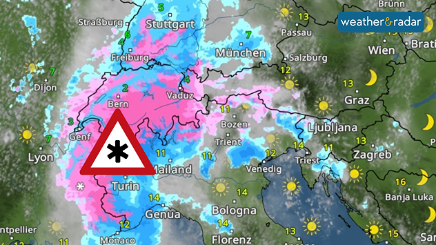
Weather map of the Alps with radar image. Above Switzerland and northern Italy, a symbol indicates snowfall in a large precipitation area over the western Alps.
Particularly from the Swiss Alps to the Maritime Alps in France, 50 to 100 centimetres of fresh snow is expected.

There is a lot of fresh snow, especially in the Western Alps. A low-pressure system is forming over the western Mediterranean, directing moist air towards the Alps. There is heavy precipitation there, which falls as snow in many valleys due to the cold air.

On Saturday night, clear skies will bring frost in some areas. This will mainly affect parts of France, the Benelux countries, western Germany and the Alpine region.

The picture is similar in the UK and Ireland, where temperatures drop to and around freezing by Saturday.

Tommy Kühnlein
More on the topic
Drought for North Wales and Upper Severn. 2% of average rainfall. . . Thursday, 23 July 2026
Split image showing a July rainfall anomaly map of Europe on the left with below-average rainfall across the UK, Ireland, and much of western and central Europe, and an active moorland wildfire on the right producing flames and thick smoke near homes.
Thursday, 23 July 2026

2% of average rainfall

Drought for North Wales and Upper Severn
Heat becoming a bigger factor in drought. New study. . . Thursday, 23 July 2026
A hand holds dry, dusty earth above a parched field. The ground is cracked and covered with plant debris – a sign of prolonged drought.
Thursday, 23 July 2026

New study

Heat becoming a bigger factor in drought
Parts of England inching towards drought. Low rivers & reservoirs. . . Wednesday, 22 July 2026
People relaxing in a park during hot weather ,with one person sunbathing on dry yellow grass beneath large leafy trees under a blue sky with scattered fair-weather clouds.
Wednesday, 22 July 2026

Low rivers & reservoirs

Parts of England inching towards drought
All weather news
This might also interest you
A frozen start to the weekend. Icy conditions. . . Friday, 13 February 2026
UK temperature map dated 14.02 showing widespread subzero values in blue shading, with readings such as −4 in Glasgow, −3 in Dublin, and −2 in London, alongside a blue thermometer icon.
Friday, 13 February 2026

Icy conditions

A frozen start to the weekend
Flooding, gales, and heavy snow. Storm Chandra. . . Tuesday, 27 January 2026
Split image showing aerial flooding in a town with muddy water covering roads on the left, and a rural road on the right blocked by heavy snowfall with vans stopped and a person walking in snow.
Tuesday, 27 January 2026

Storm Chandra

Flooding, gales, and heavy snow
Historic Storm Éowyn arrives. On this day.... . . Saturday, 24 January 2026
Split image showing a person in a yellow jacket struggling against strong winds and heavy rain on a street at night on the left, and an Irish wind forecast map on the right with red and purple shading, gusts up to 75 mph, and a wind warning icon, divided by a curved white line.
Saturday, 24 January 2026

On this day...

Historic Storm Éowyn arrives
All articles
Weather & Radar

Weather & Radar is also available on

Google Play StoreApp Store

Company

Contact us Privacy Policy Legal info Accessibility statement

Services

Uploader

Socials

facebooktwittertikToklinkList