Home
Weather London
WeatherRadar
RainfallRadar
TemperatureRadar
WindRadar
LightningRadar
Weather News
Editor's Pick
Discover the app
Weather widget
Contact us
Apps
Career
    Home / Editor's Pick /

    Stormy Tuesday - Rain and strong gusts prompt warnings in the UK and Ireland

17:05
10 November 2025

Stormy Tuesday
Rain and gusting winds prompt warnings

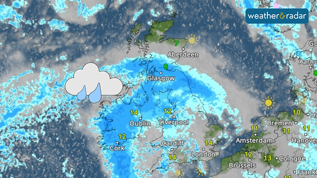
Tuesday's WeatherRadar shows widespread rain during the day.

Tuesday sees the arrival of more heavy rain in parts of the UK and Ireland, alongside gusting winds, prompting warnings.

The day begins with rain already falling in southern Ireland, Wales, and parts of south-west England for commuters as gusts reach around up to 40 mph (64 km/h) in some areas including Cork and Plymouth in the morning.

Around midday, heavy rain reaches Scotland and becomes more widespread across Ireland, likely to prompt surface flooding.

Towards the afternoon, the stronger gusts also become more widespread. Intensifying slightly, with some around 45 mph in the UK and up to 50 mph on the Isle of Man.

Check the WindRadar outlook
Ryan Hathaway
More on the topic
The Perseids reach their peak. Shooting stars overhead. . . Tuesday, 11 August 2026
Shooting stars in the night sky
Tuesday, 11 August 2026

Shooting stars overhead

The Perseids reach their peak
Getting through the latest heatwave. Tips to beat the heat. . . Tuesday, 11 August 2026
Split graphic showing temperatures up to 35°C in England and 28°C in Ireland beside a person applying sunscreen, with a heat warning symbol highlighting hot weather.
Tuesday, 11 August 2026

Tips to beat the heat

Getting through the latest heatwave
The best views of the solar eclipse. Across Europe. . . Thursday, 13 August 2026
Solar eclipse: The sun obscured between wind turbines in Sardinia
Thursday, 13 August 2026

Across Europe

The best views of the solar eclipse
All weather news
This might also interest you
Seasonal warmth between spring thunder. Your weather - Your shots. . . Sunday, 19 April 2026
Split image showing coastal sunset with layered lenticular clouds over rooftops and palm trees on the left, and a green valley with river and hills under soft daylight on the right.
Sunday, 19 April 2026

Your weather - Your shots

Seasonal warmth between spring thunder
Storm Chandra makes impact. Severe gales & heavy rain. . . Tuesday, 27 January 2026
Split image showing strong winds over the UK on a forecast map and widespread rain and snow on a weather radar map.
Tuesday, 27 January 2026

Severe gales & heavy rain

Storm Chandra makes impact
Super Typhoon Bavi threatens Taiwan. Up to 1,000 mm of rain. . . Wednesday, 8 July 2026
The image shows an intense tropical cyclone over the western Pacific, east of Taiwan and the Philippines. The centre of the system is depicted as a light purple and white vortex with a clearly visible eye, surrounded by a ring of red and orange areas indicating the strongest wind speeds. A white arrow marks the typhoon’s predicted track towards the north-west, in the direction of Taiwan. To the west of the storm lie the Philippines, with the cities of Manila and Cebu; to the north of these lies Taiwan, with Taipei. Further west, the Chinese coast, including Hong Kong, and parts of Vietnam can be seen. The coloured wind map shows predominantly green areas outside the storm’s core, indicating significantly weaker winds. White streamlines illustrate the typhoon’s anti-clockwise circulation in the Northern Hemisphere. The highest wind speeds are concentrated around the eye of the cyclone.
Wednesday, 8 July 2026

Up to 1,000 mm of rain

Super Typhoon Bavi threatens Taiwan
All articles
Weather & Radar

Weather & Radar is also available on

Google Play StoreApp Store

Company

Contact us Privacy Policy Legal info Accessibility statement

Services

Uploader

Socials

facebooktwittertikToklinkList