Home
Weather London
WeatherRadar
RainfallRadar
TemperatureRadar
WindRadar
LightningRadar
Weather News
Editor's Pick
Discover the app
Weather widget
Contact us
Apps
Career
    Home / Editor's Pick /

    Stormy for UK & Ireland: Weather locked in place by pressure

12:30
18 July 2025

Stormy for UK & Ireland
Pressure systems protecting Europe

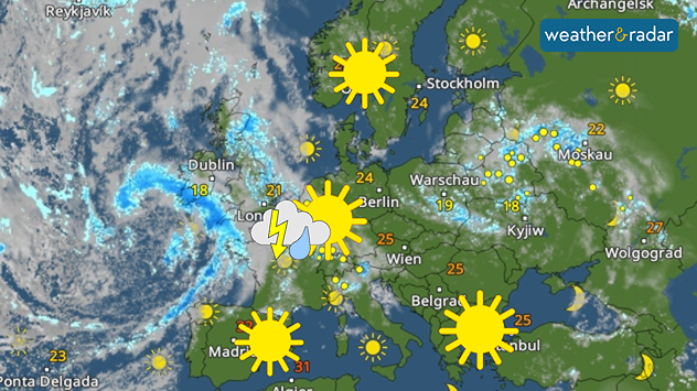
The WeatherRadar shows sunny weather in northern and southern Europe, and stormy skies for us.

Pressure systems have locked weather patterns in place.

While summer conditions are firmly established over northern and Southern Europe, with plenty of sunshine and warmth, one low-pressure system after another is passing over Central Europe.

The general weather situation will remain largely unchanged over the next few days. In Scandinavia and around the Mediterranean, the midsummer weather will continue almost unabated.

Low-pressure systems with showers and thunderstorms will remain over western and Central Europe.

Weather & Radar editorial team
More on the topic
Hurricane POLO remains dangerous. Many storms in the Pacific. . . Thursday, 24 September 2026
Thursday, 24 September 2026

Many storms in the Pacific

Hurricane POLO remains dangerous
Colourful skies and scenic clouds cover. Your weather - Your shots. . . Sunday, 20 September 2026
Split image showing a golden sunset over the sea beneath layered clouds and a pink-purple sunset reflected across calm riverside water.
Sunday, 20 September 2026

Your weather - Your shots

Colourful skies and scenic clouds cover
Equinox marks the start of autumn. Days start to get shorter. . . Wednesday, 23 September 2026
Split image showing Stonehenge in warm sunlight beside a tree-lined park glowing with vivid orange, red, and golden autumn leaves.
Wednesday, 23 September 2026

Days start to get shorter

Equinox marks the start of autumn
All weather news
This might also interest you
Bright and warm conditions take hold. Spring-like outlook. . . Thursday, 23 April 2026
Split UK map showing warm temperatures up to 21 degrees in orange on the left and clear sunny conditions with temperatures from 12 to 18 degrees on the right, with sun icons across the country.
Thursday, 23 April 2026

Spring-like outlook

Bright and warm conditions take hold
Super Typhoon Bavi threatens Taiwan. Up to 1,000 mm of rain. . . Wednesday, 8 July 2026
The image shows an intense tropical cyclone over the western Pacific, east of Taiwan and the Philippines. The centre of the system is depicted as a light purple and white vortex with a clearly visible eye, surrounded by a ring of red and orange areas indicating the strongest wind speeds. A white arrow marks the typhoon’s predicted track towards the north-west, in the direction of Taiwan. To the west of the storm lie the Philippines, with the cities of Manila and Cebu; to the north of these lies Taiwan, with Taipei. Further west, the Chinese coast, including Hong Kong, and parts of Vietnam can be seen. The coloured wind map shows predominantly green areas outside the storm’s core, indicating significantly weaker winds. White streamlines illustrate the typhoon’s anti-clockwise circulation in the Northern Hemisphere. The highest wind speeds are concentrated around the eye of the cyclone.
Wednesday, 8 July 2026

Up to 1,000 mm of rain

Super Typhoon Bavi threatens Taiwan
Seasonal warmth between spring thunder. Your weather - Your shots. . . Sunday, 19 April 2026
Split image showing coastal sunset with layered lenticular clouds over rooftops and palm trees on the left, and a green valley with river and hills under soft daylight on the right.
Sunday, 19 April 2026

Your weather - Your shots

Seasonal warmth between spring thunder
All articles
Weather & Radar

Weather & Radar is also available on

Google Play StoreApp Store

Company

Contact us Privacy Policy Legal info Accessibility statement

Services

Uploader

Socials

facebooktwittertikToklinkList